Logging Summary
|
| IODP Expedition 301: |
|
Juan de Fuca Hydrogeology
Expedition 301
Scientific Party
|
| Introduction |
|
|
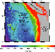
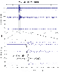
Figure
1. Bathymetric map showing
the sites drilled during IODP
Expedition 301 (black stars) and
ODP Leg 168 (red dots).
|
|
|
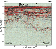
| Figure 2.
Two-way travel time seismic
reflection profile showing the
location of Site 1301 that was
drilled during IODP Expedition 301
(Expedition 301
Preliminary Report, 2004).
This seismic data was acquired
with the 2000 ImageFlux survey
(Sonne, SO149). Vertical lines on
this figure represent approximate
total depth of Holes 1301A
(shallower hole) and 1301B (deeper
hole). |
During Integrated Ocean Drilling
Program (IODP) Expedition 301, sediments
and oceanic crust were drilled at Site
1301,which is located on the Endeavour
segment of the Juan de Fuca Ridge (Figure 1).
The primary objectives of the IODP
Expedition 301 were to evaluate the
formation-scale hydrogeologic properties
within oceanic crust; determine how
fluid pathways are distributed within an
active hydrothermal system; establish
linkages between fluid circulation,
alteration, and microbiological
processes; and determine relations
between seismic and hydrologic
anisotropy (Expedition 301
Preliminary Report, 2004).
Site 1301 is located above a buried
basement ridge (Second Ridge), where
sediment thins to 250-265 m (Figure 2).
Site 1301 was positioned ~1 km SSW of
Site 1026, which was drilled during ODP
Leg 168 (Figure
1). Three holes were drilled at
Site 1301 (Hole 1301A, 1301B, and 1301C)
and logging operations were carried out
along the deeper oceanic crust interval
penetrated in Hole 1301B. For further
information and geological setting,
please refer the Expedition 301
Preliminary Report.
|
|
Logging
Operations
|
|
|
| Figure 3.
Schematic showing the
configuration of the wireline
logging tool strings that were
used during IODP Expedition 301. |
|
|
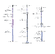
| Figure 4. Results
of triple combo measurements and
sonic tool string measurements
from Hole 1301B. Black dots in the
porosity, density, and P-wave
velocity panels represent
shipboard measurements on core
samples. |
The wireline logging operations
consisted of four tool string
deployments (Figure
3): (1) the triple combo, (2)
Ultrasonic Borehole Imager (UBI), (3)
Formation MicroScanner (FMS)/sonic, and
(4) the Well Seismic Tool (WST). Brief
descriptions of the operations and tool
string configurations are as follows:
(1) The triple combo tool string
consisted of the logging equipment head
- mud temperature (LEH-MT) cable head
with sensors for measuring spontaneous
potential (SP), temperature and tension,
the Hostile Environment Natural
Gamma-Ray Sonde (HNGS), the Hostile
Environment Lithodensity Sonde (HLDS),
the Accelerator Porosity Sonde (APS),
and the SlimXtreme Array Induction
Imager Tool (QAIT). This tool string
measured the basic physical properties
from 350 mbsf to 578.2 mbsf, without
problems (Figure
4). The caliper arm shows that the
borehole is almost in gauge below ~ 464
mbsf but very irregular and oversized
between 352 and 464 mbsf, reaching
>18 inches between 395-405 mbsf.
(2) The UBI tool string consisted of
the LEH-MT with sensors for measuring
SP, temperature and tension,
Scintillation Gamma Ray Tool (SGT), the
General-Purpose Inclinometry Tool
(GPIT), and the UBI. An obstruction was
found in the hole at 428.2 mbsf. Several
attempts to get past the obstruction
failed thus, UBI data were only acquired
from 350 mbsf to 428.2 mbsf.
(3) The FMS/sonic tool string consisted
of the LEH-MT with sensors for measuring
SP, temperature and tension, the SGT,
the Dipole Sonic Imager (DSI), the GPIT,
and the FMS. The obstruction was found
at the same depth of 428.2 mbsf
resulting in a shortened logged
interval. The sonic velocity logs
contain several isolated intervals of
with noisy data, but most of the logged
interval seems to have reliable results
(Figure 4).
(4) Rigging up procedures began with
the deployment of a generator injector
seismic source (GI-gun) consisting of a
45 in3 generator chamber volume and a
105 in3 injector chamber volume and by
placing several observers around the
ship for compliance with the IODP marine
mammal policy. The procedure included a
1-hr observation period prior to the use
of the seismic source where the Mate on
watch and the marine mammal observers on
the aft end of the ship began
observations. Observations continued
throughout the duration of the seismic
experiment and no marine mammals were
sighted within the 700 m safety zone.
After the initial observation period,
the “soft start” procedure began with
the seismic source being fired at 30-sec
intervals starting at a pressure of
500-psi and gradually increasing the
pressure to the “operational” pressure
2000 psi over a 30-minute period. During
the WST experiment, the GI-seismic
source was operated at 2000 psi air
pressure with a time delay between the
generator and injector shots of 40 ms.
As in the case of UBI and FMS/sonic
deployments, the tool could not pass the
obstruction located at 428.2 mbsf and
the WST stations were spaced at 20-m
from the top of the obstruction to the
bottom of the bottom hole assembly.
Logging
Results
|
|
|
Figure 5.
(A) WST stacked waveforms and
(B) determination of interval
velocities for the 100-m section
of open hole that was logged.
|
Resistivity, Porosity, Density,
Gamma ray, and Spontaneous potential
Most of the resistivity curves show
values within the basement ranging
between 0.27 and 146 Wm. Among the set
of resistivity curves, the 10-in depth
of investigation curves show lower
electrical resistivity values than the
other resistivity curves of the same
vertical resolution. In general, all
curves follow similar trends.
Values of neutron porosity show a large
range from 4 to 100%. Neutron porosity
values are particularly high above 462
mbsf where the borehole is enlarged and
lower in the bottommost part of the hole
where values are mostly between 5 and
20%, which represent values that are
closer to porosities measured on core
samples (~2 to 9%).
Density values range from 1.23 to
slightly over 3.00 g/cm³ over the entire
logged section of the borehole. Below
462 mbsf, density values are between 2.5
and 3.0 g/cm³ and close to the range of
values measured on core samples, which
average 2.78 ± 0.08 g/cm³. Above 460
mbsf density values are lower due to the
irregular and enlarged shape of the
borehole.
Total gamma ray values (HSGR) range
from 5.3 to 13.2 gAPI. Potassium values
are low with values between 0 and 0.48
wt.%. Thorium and uranium values are
mostly between 0 and 1 ppm. The slight
increase in gamma ray values below 515
mbsf may be caused by slightly higher
alteration, which is the only depth
interval with highly altered rocks
identified in the cores samples. Typical
secondary minerals in this interval are
saponite, iron hydroxides, and
celadonite. Celadonite may contain
potassium and thus could increase the
gamma ray values.
SP values vary between –170 and 24 mV
and tend to increase within the enlarged
borehole intervals while decreasing
within more massive intervals.
Particularly, low-values are observed
above 378 mbsf.
Sonic Velocity
P-wave velocities range from 4000 m/s
to 6000 m/s, and correlate well with the
average laboratory velocity measurements
of ~5300 m/s that were obtained from
core samples (Figure
4). S-wave velocities range from
2000 m/s to 3000 m/s. However, several
sections have anomalous velocities,
especially below 385 mbsf where both P-
and S-wave velocities are low because
the borehole is enlarged and irregular.
Although the tool worked well, the
processing of the waveforms was not
straightforward and further processing
had to be done onshore to improve the
quality of the results.
Logging Units
A preliminary interpretation of the
geophysical logs yielded the
identification of 21 logging units (Figure 4).
Most of the logging units seem to be
characterized by massive sections
bounded by fractured intervals. In
Figure 4, the yellow shading parts
represent the massive intervals and the
white shading parts represent mostly
fractured intervals. A few of the
massive flow units (purple shading on
the Figure 4)
can also be identified in the downhole
logs as slight increases in electrical
resistivity, low neutron porosity, and
high density values. Above 462 mbsf,
pillow basalt units are characterized by
the enlarged borehole intervals however,
a pillow basalt unit below 474 mbsf is
characterized by low-porosity and
high-density values with small spikes of
high-porosity and low-density that may
be related to thin fractured intervals.
Vertical Seismic Profile (VSP)
The waveforms at the each WST station
were stacked and a travel times were
determined from the first breaks of the
waveforms acquired at four stations (Figure 5).
In some instances it was difficult to
determine the first break therefore, the
median of the first break for each
stacked trace were also used to
determine interval velocities. The
gradient of the travel time first break
used to estimate an interval velocity
produced a result of ~5220 m/s whereas
the median yielded an interval velocity
of 4990 m/s. Core sample and sonic log
measurements show a slightly higher
range of velocities and the difference
may reflect the different scales of core
measurements, sonic logs, and seismic
experiments.
Borehole Images (FMS and UBI)
The quality of the FMS and UBI images
were poor because of two main reasons.
The section of the borehole that was
imaged is characterized by washouts and
irregularities that hinder the
acquisition of high-resolution images.
In addition, the new heave compensating
system used during Expedition 301 may
have not been working properly.
Summary
Overall, the logging data expand upon
core-based observations and provide in
situ measurements at Site 1301. The
triple combo was the only tool string
that provided reliable data of the
entire borehole revealing ideal places
for Packer experiments and allowing for
the interpretation of several logging
units that correlated to physical and
lithological changes identified from
core-based observations. The downhole
coverage obtained with the other tool
string deployments consisted of only 1/4
of the borehole’s total depth because of
a borehole obstruction. The VSP
experiment obtained the best results of
any subsequent tool deployment allowing
for the estimation of the shallow
basement velocity profile
|
Gerardo J Iturrino: Logging
Staff Scientist, Borehole Research
Group, Lamont-Doherty Earth Observatory
of Columbia University, PO Box 1000, 61
Route 9W, Palisades, NY 10964, USA.
|
|
|