Logging Summary
|
| IODP Expedition 303: |
|
North Atlantic Climate 1
Expedition 303
Scientific Party
|
| Introduction |
|
|
Figure
1. Map of the North
Atlantic showing the location of
Expedition 303 sites.
|
The primary objective of Expedition 303
was to place late Neogene–Quaternary
climate proxies in the North Atlantic
into a PAC (Paleointensity Assisted
Chronology), a chronology based on a
combination of geomagnetic
paleointensity, stable isotope, and
detrital layer stratigraphies. Sites
drilled during Expedition 303 are
located off Orphan Knoll (Newfoundland),
on the Eirik Drift (southeast
Greenland), on the southern Gardar
Drift, and in the central Atlantic
“ice-rafted debris (IRD) belt” (Fig. 1).
The primary logging objective of
Expedition 303 was to provide detailed
core-log integration to allow assessment
of core expansion and to provide a
quality control check of the spliced
core record. Given the high
sedimentation rates at most of the
Expedition 303 sites, a secondary
objective was to examine cyclicity
within the logging data. It was hoped
that millennial scale changes would be
identifiable in Formation MircoScanner
(FMS) data. However, because of
operational difficulties and
deteriorating weather conditions it was
only possible to deploy the “triple
combination” tool string at one site,
Site U1305. Unfortunately, this meant
that the highest-resolution tools (the
Lamont Multi-sensor Gamma ray Tool [MGT]
and the FMS-sonic) were not deployed
during Expedition 303.
|
|
Results from
Site U1305
|
|
|
|
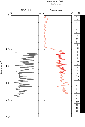
Figure
2. Caliper, main
and repeat pass gamma ray and
core recovery records for Hole
U1305C. gAPI = American
Petroleum Institute gamma ray
units.
|
|
|
| Figure 3. Caliper,
density, porosity, electrical
resistivity and photoelectric
effect (PEF) data for the interval
95 to 250 mbsf in Hole U1305C. |
|
|
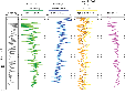
| Figure 4. Caliper,
total gamma ray and spectral gamma
ray data (K, Th, U) for the
interval 95 to 250 mbsf in Hole
U1305C. HCGR = computed gamma ray
headspace, HSGR = total spectral
gamma ray, gAPI = American
Petroleum Institute gamma ray
units, in. = inches. |
The caliper data show that the diameter
of the borehole ranged from ~13.6 to
18.0 in (Fig. 2),
resulting in data of variable quality.
Reproducibility of data is high between
passes (see gamma ray example in Fig. 2).
The density and porosity tools require
good borehole contact. Thus, intervals
with a large borehole diameter are
characterized by high porosities and low
densities (Fig.
3). Density and porosity data are
also less reliable when the caliper is
not open (i.e., above ~107 mbsf during
the main pass).
The downhole logging data suggest that
the formation is fairly uniform in the
open hole (Fig.
3). As expected, the density and
porosity data are generally inversely
related to each other and show downhole
trends of increasing density and
decreasing porosity. Resistivity values
are low reflecting the generally
moderate to high porosity sediments.
Photoelectric effect (PEF) values range
between 1.0 and 3.3 b/e-, consistent
with the clay-rich lithologies.
Extremely low PEF values (>1.8, the
PEF value of pure quartz) may be the
result of poor contact with the borehole
wall or extremely porous intervals
(seawater has a PEF value of 0.807).
Gamma-ray values increase slightly with
depth, possibly as a result of
increasing clay content. The low uranium
content of the formation results in very
similar HSGR (Total gamma ray) and HCGR
(summation of Th and K gamma rays only)
values (Fig. 4).
The uranium data suggest that total
organic carbon values in the logged
interval are consistently very low, as
shown by discrete samples. Potassium and
thorium display very similar trends
downhole, suggesting that there are no
major downhole changes in mineralogy (Fig. 4).
|
|
Core-Log
Comparisons
|
|
|
|
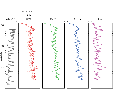
Figure 5.
Comparison of core and log
physical properties from Hole
U1305C. A: Gamma ray activity
for the interval 95 to 250 mbsf.
B: Density for the interval 95
to 250 mbsf. C: Gamma ray
activity for the interval 190 to
215 mbsf. cps = counts per
second; gAPI = American
Petroleum Institute gamma ray
units.
|
|
|
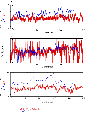
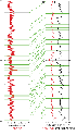
| Figure 6.
Correlation of spliced core
gamma-radiation data (corrected
counts) in red with logging data
in black, for the depth interval
of 100 to 200 m from Site U1305.
In the left-hand panel is the
spliced data in mcd; the right
hand panel shows the corrected
spliced data (in meters equivalent
logging depth or meld) and the
logging data (mbsf). Note that
spliced core record in the
right-hand panel has been smoothed
in Sagan to allow easier
correlation. cps = counts per
second; gAPI = American Petroleum
Institute gamma ray units. |
All the downhole data sets display
meter to decimeter scale variability
that are most likely the result of
subtle changes in lithology. A
comparison of log- and core-derived
natural gamma radiation and density
records shows close agreement in
downhole trends and patterns (Fig 5).
Measured density values are very similar
in both core and log data. Closer
inspection of the gamma ray data
suggests that 5-meter scale patterns can
be recognized in both the core and log
records (Fig 5).
Using the downhole log records as a
depth reference, and the software
program Sagan, it was possible to
correlate the core measurements to
equivalent logging depths to more
precisely determine the amount of core
expansion.
Figure 6
shows some of the tie points used to
integrate core and log data. By
recognizing similar patterns in the
composite core record and the logging
data, it was possible to convert the
depths for core data from mcd (meters
composite depth) to meld (meters
equivalent logging depth). Using this
method of core-log integration it will
be possible to compare various physical
properties measured in core and
downhole. This allows us to more fully
utilize and integrate measurements that
were only made either downhole (such as
spectral gamma and resistivity) or on
core (such as color).
|
Stuart Robinson: Logging Staff
Scientist, School of Human &
Environmental Sciences, University of
Reading, Whiteknights, PO Box 227,
Reading, RG6 6AB, UK.
|
|
|