Logging Summary
|
| IODP Expedition 307: |
|
Modern Carbonate Mounds:
Porcupine Basin Drilling
Expedition 307
Scientific Party
|
| Introduction |
|
|
|
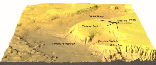
Figure
1. General view of
Modern Carbonate Mounds - IODP
Expedition 307 Porcupine
drilling area (UCD Unnithan).
|
|
|
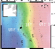
| Figure 2.
Location map of the Challenger
Mound drilled and logged sites. |
|
|
| Figure
3. B Seismic line PO10515
showing sigmoidal unit at Site
U1316 and semitransparent seismic
layer at Site U1317. |
During Expedition 307, a downslope
suite of three sites was drilled and
logged on the eastern slope of Porcupine
Seabight, west of Ireland (Fig. 1). The
sites are centered on Challenger mound,
a 170 m high, partly buried carbonate
mound in the Belgica mound province,
topped by dead coldwater coral rubble (Fig.2).
The Belgica mound province belongs to
the best documented carbonate mound
provinces worldwide. Very high
resolution seismic profiling, multibeam
bathymetry, and side-scan sonar imaging
have shed light on the stratigraphic,
structural, and morphological setting.
The mounds are rooting on a strongly
erosive unconformity and are seated
partly on an enigmatic sequence of
sigmoidal units and partly on a
semitransparent layer (Fig. 3).
The objectives of Expedition 307 can be
summarized into four major hypotheses:
• Gas seeps act as a prime trigger for
mound genesis - a case for
Geosphere-Biosphere coupling
• Mound "events" frame into a
palaeoenvironmental plot - prominent
erosional surfaces reflect global
oceanographic events
• Mounds are high-resolution
palaeoenvironmental recorders
• The Porcupine mounds are present-day
analogues for Phanerozoic reef mounds
and mud mounds
Collection of continuous downhole
logging measurements was critically
important to the scientific objectives
of Expedition 307, as the main
contribution of acquisition of in situ,
continuous multi-parameter logging data
are:
(1) To assess the physical, chemical
and structural characteristics of the
formation, and to provide the baseline
for depth matching the core-derived
composite depth (mcd) scale; and
(2) To conduct a seismic integration
(time/depth model and synthetic
seismogram) allowing identification and
dating of seismic reflectors at a
regional scale.
|
|
Tools and
Logging Operations
|
|
|
| Figure 4.
Schematic illustration of the
toolstring configurations used
during Expedition 307. |
Logging operations utilized the
standard IODP tool strings: the triple
combo with the addition of the
Temperature/Acceleration/Pressure Tool
(TAP) the Formation MicroScanner
(FMS)-sonic and the Well Seismic Tool
(WST) (Fig. 4):
- the triple combo tool string (Fig. 4a)
consisting of resistivity (phasor dual
induction tool [DIT]), bulk density
(hostile environment litho-density sonde
[HLDS]), gamma ray (hostile environment
natural gamma sonde [HNGS]), and
porosity (accelerator porosity sonde
[APS]) components, with one additional
LDEO tool that measured high-resolution
temperature/acceleration/pressure (TAP
tool);
- the FMS-sonic toolstring (Fig. 4b)
consisting of microresistivity (FMS),
dipole sonic imager (DSI), gamma ray
(scintillation gamma ray tool [SGT]),
and orientation/acceleration (general
purpose inclinometer tool [GPIT])
components;
- the WST (Fig.
4c) consists of a single geophone,
pressed against the borehole wall that
is used to record the acoustic waves
generated by an air gun located near the
sea surface, offset from the ship.
The logging plan set out in the
pre-cruise prospectus was successfully
completed (Table 1).
In a general manner collected data,
including sonic logs necessary to
seismic modelling are of excellent
quality.
| IODP Hole |
Location |
Water
depth (m) |
Total
Depth (mbsf) |
Toolstring
deployed |
Interval
logged (mbsf) |
| U1316C |
51°
22.56' N |
965 |
143 |
Triple-Combo |
60 -
140 |
|
11°
43.81'W |
|
|
FMS-sonic |
41 -
140 |
| U1317D |
51º
22.8' N |
805 |
270 |
Triple-Combo
+ TAP |
87 -
246 |
| |
11°
43.1' W |
|
|
WST |
87
- 250 (13 stations) |
| |
|
|
|
FMS-sonic |
77 -
246 |
| U1318B |
51°
26.16' N |
423 |
255 |
Triple-Combo |
81 -
255 |
| |
11°
33.0'W |
|
|
FMS-sonic |
71 -
255 |
Table 1.
Details of
logging operations completed during
Expedition 307.
Summary
and Highlights
|
|
|
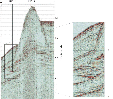
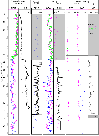
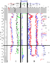
Figure 5.
Log stratigraphy at
Hole U1316C. (a) Hole shape,
total gamma ray (HSGR) and
Potassium content (HFK), (b)
thorium (HTHO) and uranium
(HURA) contributions to natural
radioactivity, (c) deep (IDPH),
intermediate (IMPH) and shallow
(SFLU) resistivities, (d)
porosity (APLC) and formation
density (RHOM), (e) capture
cross-section (SIGF) and
photoelectric factor (PEFL), (f)
downhole compressional
velocities (VP), and (g) log
sub-units.
|
|
|
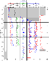
| Figure 6. Core-log
integration at Site U1316
gamma-ray, porosity, density,
velocity. Post-cruise correlation
between features recorded in these
logs (especially acoustic, density
and gamma-ray) offer potential to
provide in-situ ground truth for
core data. Note that in the
velocity plots, the range of
velocity is similar for all
datasets (1400 m/s) but absolute
values between cores and logs
differ by 300 m/s. The core values
are about 300 m/s lower than
logging data, probably due to
expansion of core now under
atmospheric pressure. |
Site U1316
Site U1316 (965 m water
depth, 51° 22.56' N, 11° 43.81'W) is
located in the downslope sediment
deposits approximately 700 meters to the
southwest of Challenger Mound. Sediments
recovered from Site U1316 located
basinward of the Challenger Mound
contain a sedimentary suite of post-,
syn- and pre-mound growth phases that
correspond to three lithological Units.
The uppermost Unit 1 is 52-58 m thick,
and mainly composed of grayish-brown
silty clay. Unit 2 is a coral bearing
facies of 10-13 m in thickness and
underlies Unit 1 with an erosional
surface. The age of this unit is mostly
early-middle Pleistocene, which
corresponds to the age of the thick
coral mound at the Site 1317. This unit
rests on the Unit 3 with a distinct
unconformity surface. The Unit 3
consists of the 92-m thick (Hole U1316C)
heterogeneous, dark green colored,
glauconitic siltstone, and is calcareous
in the lower part. Dolomite
precipitation formed lithified layers
around 72 mbsf.
After an unsuccessful
attempt to log Hole U1316A, Triple Combo
and FMS sonic downhole logs were
acquired between 60 and 140mbsf in Hole
U1316C. The density, resistivity, and
acoustic velocity logs show a steady
downhole increase due to compaction,
interrupted by 1-5-m-thick intervals of
higher values, indicating the presence
of more lithified layers (Figs 5 and 6). The PEF
values for these layers indicate they
are carbonate-rich. These lithified
layers are the cause of several strong
reflections in the sigmoidal package in
the seismic section at this site.
|
|
|
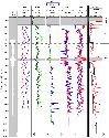
Figure 7.
Log stratigraphy at
Hole U1317D. (a) Hole shape,
total gamma ray (HSGR) and
Potassium content (HFK), (b)
thorium (HTHO) and uranium
(HURA) contributions to
natural radioactivity, (c)
deep (IDPH), intermediate
(IMPH) and shallow (SFLU)
resistivities, (d) porosity
(APLC) and formation density
(RHOM), (e) capture
cross-section (SIGF) and
photoelectric factor (PEFL),
(f) downhole compressional
velocities (VP) and interval
velocity determined by the
check-shot survey, and (g) log
sub-units.
|
|
|
|
Figure
8. Core-log
integration at Hole U1317
gamma-ray, porosity,
density, velocity.
Post-cruise correlation
between features recorded in
these logs (especially
acoustic, density and
gamma-ray) offer potential
to provide in-situ ground
truth for core data. Initial
examination shows that the
core depths are offset 4-6 m
downwards from the log
depths.
|
|
|
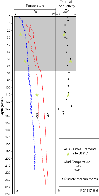
| Figure 9.
Thermal measurements at
Site U1317. (a) Drilling mud
temperature measurements using
the EMS (blue, down logging) and
TAP tool (red, down and up
logging) compared to ADARA
measurement, (b) thermal
conductivity measurements on
core (dot) and in-situ (ADARA
measurement, star). |
Site U1317
Site U1317 is located on
the northwest shoulder of the Challenger
Mound (51º 22.8' N, 11º 43.1' W, in 781
to 815 m water depth). Sediments from
the on-mound Site U1317 can be divided
into two units; the Pleistocene
coral-bearing unit (Unit 1) and the
Neogene siltstone (Unit 2). Unit 1
consists mainly of coral (mostly
identified as Lophelia pertusa),
floatstone, rudstone, wackestone, and
packstone, and repeats cyclic color
change between light grey and dark
green. This coral mound unit rests on
Unit 2 with a sharp erosional boundary
that appears identical to the boundary
between Units 2 and 3 of Site U1316.
Unit 2, consists of glauconitic and
partly sandy siltstone. It is
lithologically correlated with Unit 3 at
Site U1316.
Triple Combo, FMD-Sonic
downhole logs, and a zero-offset VSP
were between 80 and 245 mbsf in Hole
U1317D. The density, resistivity, and
acoustic velocity logs show a steady
downhole increase due to compaction,
interrupted by 1-5-m-thick intervals of
higher values, indicating the presence
of more lithified layers similarly to
Hole U1316C. The PEFL values for these
layers indicate they are carbonate-rich.
These lithified layers are the cause of
the high amplitude sigmoidal reflectors
observed in the seismic profiles (Figs 7 and 8). Interval
velocities were calculated from the
checkshot survey (Table
2): they confirm the values of the
acoustic velocity logs, but show that
the physical property measurements made
on the cores significantly underestimate
the in-situ velocity.
| Stack
number |
Measured
depth |
Depth |
Measured
1W-TT |
Corrected
1W-TT |
Interval
velocity |
| |
(m) |
(mbsf) |
(ms) |
(ms) |
(ms) |
| 13 |
905 |
94 |
583.43 |
583.86 |
1767.86 |
| 12 |
915 |
104 |
589.07 |
589.52 |
1982.16 |
| 11 |
925 |
114 |
594.11 |
594.56 |
1723.99 |
| 10 |
935 |
124 |
599.90 |
600.36 |
1938.86 |
| 9 |
945 |
134 |
605.04 |
605.52 |
1770.69 |
| 8 |
955 |
144 |
610.68 |
611.17 |
2032.27 |
| 7 |
965 |
154 |
615.59 |
616.09 |
1901.70 |
| 6 |
980 |
169 |
623.52 |
624.03 |
2005.52 |
| 5 |
995 |
184 |
630.98 |
631.51 |
1978.63 |
| 4 |
1010 |
199 |
638.49 |
639.04 |
1669.09 |
| 3 |
1025 |
214 |
646.15 |
646.71 |
2201.70 |
| 2 |
1040 |
229 |
652.90 |
653.47 |
2161.09 |
| 1 |
1056 |
245 |
660.29 |
660.88 |
- |
Table 2.
Check-shot survey at Hole U1317D
|
|
|
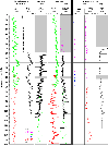
Figure 10.
Log stratigraphy at
Hole U1316C. (a) Hole shape,
total gamma ray (HSGR) and
Potassium content (HFK), (b)
thorium (HTHO) and uranium
(HURA) contributions to natural
radioactivity, (c) deep (IDPH),
intermediate (IMPH) and shallow
(SFLU) resistivities, (d)
porosity (APLC) and formation
density (RHOM), (e) capture
cross-section (SIGF) and
photoelectric factor (PEFL), (f)
downhole compressional
velocities (VP), and (g) log
sub-units.
|
|
|
| Figure 11.
Core-log integration at Site
U1316 gamma-ray, porosity,
density, velocity. Post-cruise
correlation between features
recorded in these logs (especially
acoustic, density and gamma-ray)
offer potential to provide in-situ
ground truth for core data. |
Site U1318
Site U1318 (423 m water
depth, 51° 26.16' N, 11° 33.0'W) is
located in on the eastern slope of the
Porcupine Seabight on the southwest
continental margin of Ireland and is
upslope from the Belgica Mound Province,
including Challenger Mound. Sediments
from the up-slope Site U1318 were
divided into three units based on
sediment colors, erosional surfaces, and
biostratigraphy. The uppermost Unit 1 is
79.9 - 82.0 m thick, and consists of
brown-colored silty clay with black
motted structure, which is partly
laminated and bioturbated. Dropstones
are common in this unit. Across a
distinct erosional surface, Unit 2 of
4-6 m thick underlies. This unit mainly
consists of olive-gray, medium-fine sand
interbedded with dark yellowish-brown
silty clay. The sand beds are normal
graded with sharp lower and upper
boundaries. Dropstones, up to 3 cm in
diameter, are found in both sand and
clay horizons. The base of this unit is
a conglomerate resting on a distinct
erosional surface. It is 5-10 cm thick,
and associated with black-colored
apatite nodules. The Unit 3 of 155 m
thick (Hole U1318B) consists of dark
green siltstone, which frequently
intercalates with sandstone layers in
the upper and lower horizons. The
siltstone tends to become calcareous to
downward.
Triple Combo and FMS sonic downhole logs
were acquired between 70 and 240 mbsf in
Hole U1318B. The downhole logs are
characterized by low amplitude
variations in lithological subunits 3A
and 3B (92-192 mbsf), and by increased
velocity and thin lithified layers in
subunit 3C (below 192 mbsf) (Figs 10 and 11). The
hiatus represented by the oyster bed at
the base of unit 2 is rich in uranium
(as seen in the natural gamma radiation
logs), which tends to accumulate at
hiatuses and condensed intervals. Major
changes in physical properties were
observed at lithological unit boundaries
that can be directly related to
reflectors in the seismic section. The
sand layers, silty clays, dropstones and
oyster bed of lithological Unit 2 create
a high amplitude reflector in the
seismic profiles, and this erosive
reflector has been tentatively
identified as the upslope continuation
of the moundbase reflector. The
enigmatic low amplitude seismic package,
whose identification was one of the main
aims of drilling this site, corresponds
to homogeneous calcareous silty clays.
Lithostratigraphic Subunit 3C, below 192
mbsf, is characterized by a slight
general increase in density in
combination with some high density thin
beds, and corresponds with high
amplitude, high frequency parallel
reflectors which can be traced along the
seismic profile to the sigmoid unit at
Site U1316.
Conclusion
All of the three sites on Expedition
307 were logged, with a checkshot survey
undertaken in Site U1317 (Challenger
Mound). High quality data was acquired
in all of the logged holes due to a
combination of good heave compensations
and excellent borehole conditions. The
logging data will be used for a range of
research topics including,
- (1) core-log correlation for refining
core composite depth splices and
correction of core physical properties
for in-situ condition, a necessary step
to obtain correct sedimentation and
mass-accumulation rate;
- (2) core-log-seismic integration and
structural use of FMS images for
interpreting the complex seismic
stratigraphy of Porcupine Seabight by
performing a core - log - seismic
integration (seismic modelling) and
characterizing azimuth and dip of
bedding and fractures identified on FMS
images (manual picking);
- (3) high-resolution analysis of
micro-resistivity logs (FMS images) for
cyclostratigraphic analyses.
Already many results are clear, as
detailed in the initial reports. The
mound is composed of coral, clay, and
coccoliths down to its base at 130-155
mbsf, and at least 10 distinct layers -
growth rings of the coral mound - are
evident in the lithology and physical
properties. Much of the late Pleistocene
material has been eroded from the top of
the mound, while at the same time
siliciclastic sediment is building up in
drifts both upslope and downslope: the
mound is slowly being buried. The theory
that this mound is built from carbonate
precipitated by microbes fed by methane
seeps has been disproved. The lithology
and age of the enigmatic sedimentary
packages that underlie the mound, known
previously only from seismic lines, have
been identified. The mound is rooted on
an erosive unconformity that has been
identified in all three sites, and
directly below the mound a thin layer of
early Pliocene sediments overlies a
thick early Miocene package of
green-grey calcareous siltstones.
Based on data collected at Site U1318
further studies will allow detailed
characterization of the semitransparent
basement layer, off-mound Site U1316.
Data from the basal sequence on-mound
Site U1317 will allow investigation on
the nature of the sigmoidal units.
Detailed studies at both Sites U1316 and
U1318 will refine the age of the
unconformity and the importance of the
hiatus. Finally, data from the on-mound
Site U1317 will unveil the environmental
record locked in a carbonate mound and
will shed light on the processes that
may have controlled the genesis of the
mound, and assessing the importance of
environmental forcing factors.
|
| |
Philippe Gaillot: Logging Staff
Scientist, Center for Deep Earth
Exploration (CDEX), Japan Marine Science
and Technology Center, Yokohama
Institute for Earth Sciences, 3173-25
Showa-machi, Kanazawa-ku, Yokohama,
Kanagawa 236-0001, Japan
|
|
|