Logging Summary
|
| IODP Expedition 308: |
|
Gulf of Mexico
Hydrogeology
Expedition 308
Scientific Party
|
| Introduction |
|
|
|
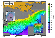
Figure
1. Bathymetric image of
the continental slope of the
Gulf of Mexico. Indicated are
the drilling locations at the
Brazos-Trinity Basin #4 (Site
U1319, U1320, and U1321) and
the Mars-Ursa Basin (Site
U1322, U1223, and U1324).
|
Integrated Ocean Drilling Program
(IODP) Expedition 308 was the first part
of a two-component program dedicated to
studying overpressure and fluid flow on
the Gulf of Mexico continental slope (Figure 1),
where rapid sedimentation overlaying a
mobile salt substrate is the driving
force behind many of the active
processes present. Drilling and logging
operations were performed at two basins
in the northern Gulf with very different
sedimentation histories.
The operations were aimed at evaluating
the impact of different depositional
settings and rates on sediment
properties and fluid flow. The
Brazos-Trinity Basin #4 (Figure 1),
one of a chain of five local basins, is
considered a classic model for the
formation of deep-water turbidite
deposits. In contrast to this is the
Ursa Basin, 300 km to the NE of
Brazos-Trinity Basin #4, where high
sedimentation rates created
overpressure. The sedimentary succession
in the Ursa Basin is composed
predominately of non-permeable mudstone
above permeable interbedded sand and mud
representing the “Blue Unit.”
Consequently, drilling operations in the
Ursa Basin were challenging due to the
risk of creating shallow water flows by
penetrating overpressured units. The
measuring-while-drilling and
logging-while-drilling operations were
crucial to the primary goal of
Expedition 308 and provided the best
means to drill and provide physical
measurements in this overpressured
basin.
|
|
Logging Tools
|
|
|
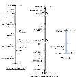
| Figure 2a.
Schematic showing the
configuration of the wireline
logging tool strings that were
used during IODP Expedition 308. |
|
|
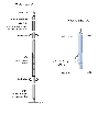
Figure 2b. Results
of triple combo measurements and
sonic tool string measurements
from Hole 1301B. Black dots in the
porosity, density, and P-wave
velocity panels represent
shipboard measurements on core
samples.
|
|
|
| Figure
2c. Masuring while drilling
and logging while drilling
(MWD/LWD) tool string used at each
site. |
|
|
| Table
1. Summary of holes logged
and tools deployed during IODP
Expedition 308. See text for
details. |
|
|
| Table
2 . Measurements recorded
during measuring while drilling
(MWD) and logging while drilling
(LWD) operations |
The logging program on Expedition 308
wasdesigned to obtain data needed to
illuminate controls on slope stability,
seafloor seeps, and large-scale fluid
flow. Standard wireline tools -- the
triple combo, the FMS/Sonic and the Well
Seismic Tool (WST) -- were deployed at
Hole U1320A (Figure
2a, Table
1).
The second wireline operation at Hole
U1324A was run with a modified tool
string and the WST (Figure 2b)
to supplement the
measuring-while-drilling (MWD) and
logging-while-drilling (LWD) operations.
Details on standard wireline tools used
during Expedition 308 can be found here.
Drilling in the overpressured Ursa
Basin carried potential risks and the
MWD/LWD operation was therefore crucial
to the primary goal of Expedition 308.
These also provided the best means to
drill and provide physical measurements
in this overpressured basin. The LWD and
MWD tools used during Expedition 308
included the GeoVISION Resistivity (GVR)
tool, the Array Resistivity Compensated
(ARC) tool, the Power Pulse
measuring-while-drilling (MWD) tool, and
the VISION Density Neutron (VDN) tool. Figure 2c
shows the configuration of the MWD/LWD
bottom hole assembly (BHA), and Table 2
lists the set of measurements recorded.
This was the first time the ARC tool was
used during an ODP or IODP expedition.
The GVR tool provided shallow-, medium-
and deep-focused resistivity
measurements of the formation and
azimuthally orientated images of the
borehole wall. The ARC tool is capable
of multi-depth borehole compensated
real-time and memory resistivity and
gamma radiation measurements. The
measured resistivity utilizes
electromagnetic wave propagation in the
formation as opposed to current flow to
the formation in the GVR tool. Also
included in the collar of the ARC is the
Annular Pressure-While-Drilling (APWD)
sensor. The APWD sensor is capable of
measuring the borehole annulus pressure
and temperature. The MWD PowerPulse tool
transmits data by generating a
continuous mud-wave transmission within
the drilling fluid and by changing the
phase of this signal (frequency
modulation) to transmit relevant bit
words representing information from
various sensors. The VDN tool provides a
borehole-compensated density
measurement, a photoelectric effect
value, and a neutron porosity
measurement.
|
| Logging Operations and
Technical highlights |
Following completion of coring in Hole
U1320A, the logging operations in the
Gulf of Mexico began with three wireline
deployments. In the first pass with the
triple combo, an obstruction at 173 mbsf
prevented the tool string from reaching
the bottom of the hole. This obstruction
was passed during the second triple
combo run, which reached the total depth
of 299.6 mbsf. The FMS/Sonic tool string
deployment reached the total depth of
the borehole with both main and repeat
passes up to pipe depth at 62.5 mbsf.
The lockable flapper valve (LFV)
temporarily obstructed the tool string
entry into the borehole. The LFV also
obstructed lowering the WST tool into
the borehole and seawater was pumped to
help open the valve.
Hole U1320B was the first MWD/LWD hole
drilled during Expedition 308, followed
by U1319B and U1321A. The identical
bottom hole assembly and tool
configuration was used for each
Brazos-Trinity site. The total depth at
each hole was reached with penetration
rates of ~25 m/hr. Real-time data were
transmitted to the surface at a rate of
24 Hz. Hole U1320B was drilled 20 m
deeper than the adjacent cored hole to
ensure that the topmost sensors in the
MWD BHA recorded measurements to the
total depth of Hole U1320A.
Logging operations at
Brazos-Trinity Basin #4
Following completion of coring in Hole
U1320A, the logging operations in the
Gulf of Mexico began with three wireline
deployments. In the first pass with the
triple combo, an obstruction at 173 mbsf
prevented the tool string from reaching
the bottom of the hole. This obstruction
was passed during the second triple
combo run, which reached the total depth
of 299.6 mbsf. The FMS/Sonic tool string
deployment reached the total depth of
the borehole with both main and repeat
passes up to pipe depth at 62.5 mbsf.
The lockable flapper valve (LFV)
temporarily obstructed the tool string
entry into the borehole. The LFV also
obstructed lowering the WST tool into
the borehole and seawater was pumped to
help open the valve.
Hole U1320B was the first MWD/LWD hole
drilled during Expedition 308, followed
by U1319B and U1321A. The identical
bottom hole assembly and tool
configuration was used for each
Brazos-Trinity site. The total depth at
each hole was reached with penetration
rates of ~25 m/hr. Real-time data were
transmitted to the surface at a rate of
24 Hz. Hole U1320B was drilled 20 m
deeper than the adjacent cored hole to
ensure that the topmost sensors in the
MWD BHA recorded measurements to the
total depth of Hole U1320A.
Logging operations at Ursa
Basin
Drilling in the Ursa Basin carried the
significant risk of encountering
shallow-water flow. This potential risk
occurs when overpressured and
unconsolidated sands are penetrated and
flow into the borehole. These sands can
be expelled at the seafloor and may lead
to slope instabilities. To counter this
problem, the identical MWD/LWD bottom
hole assembly and tool configuration
assembled for the Brazos-Trinity Basin
#4 was used to drill at the Ursa Basin.
The first MWD/LWD dedicated hole in the
overpressured Ursa Basin was drilled at
Site U1322. For the first time in the
history of IODP (and DSDP/ODP), MWD/LWD
was tested as a viable tool to monitor
real time pressure in a hole before
coring the site. MWD/LWD drilling
proceeded without incident at Hole
U1322A and U1324A. At Hole U1323A, a
~3-m thick sand layer was encountered at
approximately 198 mbsf and a pressure
increase of 150 psi over the background
drilling pressure in the APWD log was
observed. The overpressure was
stabilized and drilling operations
continued after a wiper trip and the
pumping of weighted mud in the hole. At
242 mbsf, a rapid drop in gamma
radiation, suggestive of a second
potentially overpressured sand interval,
was observed in the data and drilling
operations were terminated. A free-fall
funnel was dropped on the seafloor to
facilitate re-entering the hole, the
MWD/LWD BHA was tripped to the surface,
and cementing operations took place in
order to comply with the Expedition 308
operations protocol. A subsequent camera
survey showed no evidence of flow.
Drilling objectives for Site U1323 were
achieved in three different ways: (1)
overpressure was evidenced during
LWD/MWD operations, (2) the IODP
approach to “riserless-controlled
drilling” proved efficient in
controlling the flow, and (3) data
obtained at Site U1323 provides
information on the lateral continuity
and the stratal architecture of the Ursa
Basin.
Following completion of the MWD/LWD
operation in Hole U1324A and prior to
cementing, two wireline logging tools
were deployed to obtain data that were
not acquired with the MWD/LWD string. A
tool string consisting of the HNGS, the
DSI, and the GPIT was deployed first and
the end of pipe was set at ~49 mbsf. An
obstruction was encountered at 507 mbsf
and logging commenced from this point.
Although the same obstruction was
encountered during the second pass,
logging commenced this time from 509.5
mbsf. The second wireline deployment
employed the WST to conduct a checkshot
survey. The LFV obstructed lowering the
WST into the open hole and seawater had
to be pumped to help open the valve. A
bad electrical line to the main trigger
box and a corroded plug connecting the
electrical leads to the GI gun also
delayed the checkshot survey.
|
| Logging Summaries |
Logging operations during Expedition
308 at Brazos-Trinity Basin #4 and Ursa
Basin provided a large volume of high
quality data. This summary highlights
some key points; for further discussion
of the data and a detailed geological
background the reader is referred to the
Expedition 308 Preliminary Report
and the Expedition 308 Proceedings
Volume.
Brazos-Trinity Basin #4
|
|
|
Figure
3. BSummary of the
wireline logging results
obtained at Hole U1320A
|
|
|
Figure
4. FMS images of Hole
U1320A showing evidence for
potential slump surfaces, high
angle deformation and
lithological changes.
|
|
|
Figure
5. Summary
of measuring while drilling and
logging while drilling (MWD/LWD)
results obtained at the
Brazos-Trinity Basin #4 Hole
U1319B.
|
|
|
Figure
6. Summary of measuring
while drilling and logging while
drilling (MWD/LWD) results
obtained at the Brazos-Trinity
Basin #4 Hole U1320B.
|
|
|
| Figure
7. Summary of
measuring while drilling and
logging while drilling (MWD/LWD)
results obtained at the
Brazos-Trinity Basin #4 Hole
U1321A. |
|
|
| Figure
8. Resistivity image
of Hole U1320B showing east-west
orientated breakouts. |
|
|
| Figure
9. GeoVISION
resistivity (GVR) image of Hole
U1320B. Apparent are thin sand
beds within Lithostratigraphic
Subunit IIe of Hole U1320B and a
sharp contact with the top of
Lithostratigraphic Unit III that
correlates to seismic reflector
R30. |
|
|
| Figure
10. GeoVISION
resistivity (GVR) image of Hole
U1320B revealing the existence
of steeply dipping beds within a
clay-rich unit corresponding to
Lithostratigraphic Unit V. |
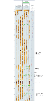
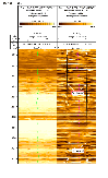
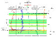
Figure 3
summarizes the wireline logging results
obtained at Hole U1320A. The data allow
for a clear separation of the logged
lithologies into two large intervals on
the basis of changes in velocity,
resistivity, bulk density, and porosity.
These intervals generally correspond to
the major lithology changes identified
in the recovered cores. Low gamma
radiation values (<60 gAPI) can be
correlated to sand-prone layers in the
core samples, whereas clay layers
display higher values (>70 gAPI).
However, low gamma radiation values
observed in lithostratigraphic Unit III
may be related to the abundance of
calcareous foraminifera and microfossils
usually characterized by low radiogenic
element concentration. Low resistivity,
gamma radiation, density and
compressional velocity values correspond
to borehole washouts. These result in
prominent anomalies, in particular at
depths of 80, 110, 140 and 170 mbsf.
Below 176 mbsf the borehole is
characterized by systematic density
increase, interrupted only by a
sand-rich layer at 230 mbsf, indicative
of increasing compaction with depth.
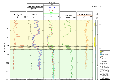
FMS images of Hole U1320A (Figure 4)
show evidence for potential slump
surfaces, high angle deformation and
lithological changes, which could
contribute to seismic reflections. The
resistivity contrast between the sand
and clay sediments compares well with
other log curves. However, at increased
caliper values, the quality of the FMS
images in these sediment sections is not
reliable. Preliminary analyses of the
FMS images show that in many intervals
the borehole is irregular, resulting in
an uneven contact of the FMS pads with
the borehole wall. Nevertheless, good
quality images in some intervals provide
information that could not be gleaned
from the cores, particularly where
sedimentary and structural features were
severely disturbed by the XCB coring
process.
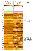
MWD/LWD operations at Holes U1319B,
U1320B, and U1321A provide data coverage
by all tools over the cored intervals
(Figures 5,
6 and 7). In
addition, the MWD/LWD data supplement
the intervals not covered by the
wireline measurements at Hole U1320A (Figure 3).
Overall, hole quality in the uppermost
borehole sections was in general more
variable, with several caliper
measurements reaching at least 43 cm.
However, gamma radiation, resistivity
and bulk density results obtained at
Hole U1319B suggest a normal compaction
trend in the clay-rich section of Site
U1319 (Figure 5).
In contrast, data from Hole U1320B and
Hole U1321A are highly variable, with a
series of intercalated sand and clay
intervals dominating the uppermost
stratigraphy. Low density and high
porosity values also reflect the
potential presence of sand units and
corresponding enlarged borehole
dimensions. The data trends in the lower
part of these holes are signatures of a
normal compaction trend where pore
volume and water content decrease with
depth because vertical effective stress
is increasing.
Resistivity images of Hole U1320B and
U1321A show apparent breakouts at the
bottom of each borehole with an
east-west orientation (Figure 8).
These breakouts indicate a north-south
maximum horizontal stress direction that
can be attributed to lateral loading by
high input of siliciclastic material
derived from river plumes, turbidity
currents, and/or slump deposits on the
basin flanks. The resistivity images are
also characterized by a series of thin
alternating resistive and conductive
laminations that may represent
variations in silt content. Steep
features at the bottom of Hole U1321A
have been identified as potential slump
deposits or faulted blocks.
The GVR resistivity images also proved
useful in identifying thin sand beds
within Lithostratigraphic Subunit IIe of
Hole U1320B and a sharp contact with the
top of Lithostratigraphic Unit III that
correlates to seismic reflector R30 (Figure 9).
In addition, the resistivity imaging at
this hole reveals steeply dipping beds
within a clay-rich unit corresponding to
Lithostratigraphic Unit V (Figure 10).
The data acquired during the MWD/LWD
operations at Brazos-Trinity Basin #4
make a bed-to-bed correlation between
the sites possible. The acquired data
are highly valuable for the study of
sandy turbidites. Drilling at Site U1321
was the first MWD/LWD experience during
Expedition 308 in the normally pressured
Brazos-Trinity Basin #4 and an excellent
exercise in preparation for MWD/LWD
drilling in overpressured sediments at
Ursa Basin.
Ursa Basin
|
|
| Figure 11.
Summary of measuring while
drilling and logging while
drilling (MWD/LWD) results
obtained at Hole U1322A in the
Mars-Ursa region. Resistivity
and gamma radiation measurements
show the highest variability and
allow correlation between
several units defined by visual
observation of the cores and to
seismic Reflectors S10 and S30. |
|
|
Figure 12. Summary of
measuring while drilling and
logging while drilling (MWD/LWD)
results obtained at Hole U1323A
in the Mars-Ursa region (see Figure 1).
The logging data correlate well
to the data obtained at Site
U1324 and Site U1322.
|
|
|
| Figure
13. Summary of measuring
while drilling and logging while
drilling (MWD/LWD) results
obtained at Hole U1324A in the
Mars-Ursa region (see Figure 1). |
|
|
|
Figure 14. GeoVISION
electrical images obtained at
Site U1322 reflecting the
occurrence of undisturbed
sediments but also of
contorted and faulted
sediments.
|
|
|
| Figure
15. GeoVISION
electrical images obtained at Site
U1322. The most striking features
are parallel east-west orientated
contours of analogue resistivity
that may represent breakouts
indicating the direction of the
minimal horizontal stress. |
|
|
| Figure
16. Resistivity
image data showing several highly
deformed intervals in Hole U1324A
confirming the original
logging-seismic interpretation and
the presence of several mass
transport deposits. |
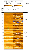
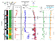
Hole U1322A represents the first
drilling location in the Ursa Basin and
is characterized by relatively uniform
logging data, mostly indicating clay,
mud, and occasionally silt (Figure 11).
Resistivity and gamma radiation
measurements show the highest
variability and allow correlation
between several units defined by visual
observation of the cores and to seismic
Reflectors S10 and S30. In general,
gamma radiation and resistivity log
responses proved to be particular useful
in identifying lithostratigraphic units
at each Ursa Basin site. The logging
data strongly support the division of
the lithostratigraphic column
encountered into lithostratigraphic
units (e.g. Units I and II) and subunits
(Subunit Ia and Ib). These are well
characterized in the LWD and wireline
log responses (Figures 11, 12, and 13). Despite
not coring Site U1323, the good-quality
logging data (Figure
12) proved to be valuable for
analysis of the stratigraphic history of
the Ursa Basin. The logging data
correlate well to the data obtained at
Site U1324 and Site U1322 for the upper
borehole section and confirm the
predominance of mud and clay rich units,
including two mass transport deposits.
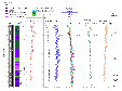
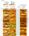
The GVR electrical images obtained at
Site U1322 and U1324 reflect the
occurrence of undisturbed sediments but
also of contorted and faulted sediments
(e.g., Figure
14). The most striking features
are parallel east-west orientated
contours of analogue resistivity that
may represent breakouts (Figure 15)
indicating the direction of the minimal
horizontal stress. Resistivity image
data show several highly deformed
intervals confirming the original
logging-seismic interpretation of the
presence of several mass transport
deposits (e.g., Hole U1324A, Figure 16).
These mass transport deposits also
display characteristics of lower bulk
density and resistivity compared with
surrounding undeformed sediments. Site
U1324 logging data also provide a
detailed picture of the bedding style
and lithofacies overlying the “Blue
Unit” and allow for interpreting the
evolution of the eastern levee of the
Southwest Pass Canyon channel-levee
system.
|
| Conclusions |
During Expedition 308, seven holes were
logged, in generally excellent
conditions, providing an exceptional
data set to help characterize the
spatial variation in composition,
deformation, and rock properties in a
flow-focusing environment. These data
provide valuable insights into basin
dynamics and basin fill in space and
time. The resolution of the MWD/LWD and
wireline logging data obtained are high
enough to allow a bed-by-bed correlation
of the basin fill.
The success of the logging program
included the first-ever attempt in the
Ursa Basin within IODP (and DSDP/ODP) to
use MWD/LWD as a predictive tool for
coring, and to make an assessment of
flow of overpressured fluids into the
drill hole in real time. This capability
was put to the test when drilling in
Hole U1323A encountered an overpressured
sand unit and annular pressure recorded
a sudden and substantial increase. It
was demonstrated that situations like
this can be controlled, and operations
can be safely concluded under the
operations protocol for Expedition 308.
|
Marc Reichow: Logging Trainee,
Department of Geology, University of
Leicester, Univresity Road, Leicester,
LE1 7RH, UK
Gerardo J Iturrino: Logging
Staff Scientist, Borehole Research
Group, Lamont-Doherty Earth Observatory
of Columbia University, PO Box 1000, 61
Route 9W, Palisades, NY 10964, USA
|
|
|