Logging Summary
|
| IODP Expeditions 309 &
312: |
|
Superfast Spreading Rate
Crust 2 and 3
Expedition 309 and
Expedition 312 Scientific Parties
|
| Introduction |
|
|
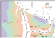
Figure
1. Age map of the Cocos-,
Pacific-, and Nazca Plates with
isochrones at 5-Ma intervals.
The locations of deep drill
holes into the oceanic crust of
Hole 1256D and Site 504 are
shown.
|
Integrated Ocean Drilling Program
(IODP) Expeditions 309 and 312 were part
of a three-component programs with the
objective to deepen Hole 1256D initiated
during Ocean Drilling Program (ODP) Leg
206. Hole 1256D is located in the
eastern equatorial Pacific (Figure 1)
and was drilled into 15 Ma crust that
formed at the East Pacific Rise during a
period of superfast spreading (>200
mm/y).
Wireline operations during Leg 206
provided high-quality data (Pezard and
Anderson, 1989) on the in situ physical
properties of the upper part of the
oceanic crust combined up to a depth of
~752 mbsf. Expeditions 309 and 312 were
highly successful continuations of this
drilling effort with the agenda to
provide further constraints on the
physical properties in deeper sections
of the oceanic crust. The primary
logging objectives were to refine the
volcanic stratigraphy, eruptive
morphology, and variations in
seawater-basalt alteration as a function
with depth at a superfast spreading
centre and in particular of the
sheeted-dikes to gabbro transition. Hole
1256D was extended to 1255 mbsf during
Expeditions 309 and finally deepened to
1507 mbsf during Expedition 312.
|
|
Logging Tools
|
|
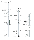
|
Figure
2a. Schematic illustration
of wireline tool string
configurations used at Hole
1256D during Expeditions 309 and
312
|
|
|
| Figure 2b.
Schematic illustration of the
Versatile Seismic Imager tool used
during Expedition 312. |
The logging program on Expeditions 309
and 312 were designed to obtain data
needed to illuminate the physical
properties of the drilled rocks and shed
light on the structure of the oceanic
crust formed at a superfast spreading
center. Standard wireline tool strings
-- the Triple Combo, the Formation
MicroScanner (FMS)/Sonic, and Well
Seismic Tool (WST), -- were deployed
during Exp 309 (Figure 2a).
In addition to the standard wireline
tool strings the Versatile Seismic
Imager (VSI) and the Temperature
Acceleration Pressure (TAP) combine with
the Dual LateroLog (DLL) and
Environmental Mechanical Sonde (EMS)
were deployed during Exp 312 (Figure 2b).
Details on standard wireline tools can
be found here.
Logging
Operations & Technical
Highlights
|
|
| Figure 3.
Logging operations at Hole 1256D
during Expeditions 309 and 312.
Depths are shown in meters below
seafloor (mbsf). HNGS = Hostile
Environmental Gamma Ray Sonde, APS
= Accelerator Porosity Sonde, HLDS
= Hostile Environmental
Lithodensity Sonde, DLL = Dual
LateroLog, TAP =
Temperature-Acceleration-Pressure
tool, SGT = Scintillation Gamma
Ray Tool, DSI = Dipole Sonic
Imager, GPIT = General Purpose
Inclinometer Tool, FMS = Formation
MicroScanner, UBI = Ultra Sonic
Borehole Imager, VSI = Versatile
Seismic Imager, EMS =
Environmental Mechanical Sonde. |
Expedition 309 pre- and
post-drilling logging operations
Logging during Exp 309 was split into
pre- (phase 1) and post-drilling
(phase2) operations (Figure 3)
using standard tool strings (Figure 2).
The primary purpose of the two
pre-drilling logging deployments were to
check the condition of ODP Hole 1256D
and identify borehole wall breakouts,
and variations in hole diameter.
Post-drilling logging operations (Figure 3)
were dedicated to provide constraints on
the physical properties of the newly
drilled sections of the oceanic crust
and determine in as much coring
influenced borehole conditions. Despite
several attempts a fifth logging run
including the WST could not be deployed
and the logging run was abandoned. All
successfully deployed logging operations
provided high quality data overlapping
data previously collected during Leg
206.
Expedition 312 logging operations
Prior to Exp 312 logging operations the
bit was placed in the open hole at ~20 m
below the 16-inch casing shoe at a depth
of ~290 mbsf (Figure 3).
The hole was successfully logged with
six different tool strings: the triple
combo; VSI; FMS with Scintillation Gamma
Ray Tool (SGT) and Dipole Sonic Imager
(DSI), Ultrasonic Borehole Imager (UBI)
with the General Purpose Inclinometer
(GPIT), SGT, and DSI tools; FMS with SGT
only; and the TAP, DLL, SGT, and EMS.
The Triple Combo made two passes, from
1440 to 343 mbsf and from 1438 to 1080
mbsf. A check shot experiment using the
VSI was conducted at 58 stations ~22 m
apart from a maximum depth of 1383 mbsf.
The UBI with the GPIT, SGT, and DSI
tools logged from 1430 to 1099 mbsf,
followed by a repeat pass covering the
interval from 1433 to 1089 mbsf. The
Formation MicroScanner was combined with
the SGT and logged the hole from 1437 to
1089 mbsf and from 1436 to 1101 mbsf. A
last logging suite was made up of the
TAP, DLL, and SGT and logged the hole
from 1440 mbsf to 290 mbsf.
|
| Logging Results |
Wireline logging operations during
Expeditions 309 and 312 built on the
success of Leg 206, and provided for the
first time in the history of DSDP, ODP
and IODP in situ physical properties of
a complete section of the oceanic crust
including the sheeted dikes–gabbro
transition.
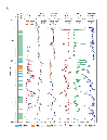
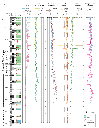
Expedition 309 results
Wireline operations during Expedition
309 provided high-quality data on the in
situ physical properties of the upper
part of the oceanic crust combined up to
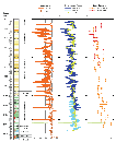
a depth of ~1220 mbsf (Figure 4a,
4b, 4c, and
4d).
Caliper readings derived from triple
combo and FMS-sonic tool strings show
generally good borehole conditions. The
average hole diameter measurements from
the FMS/sonic calipers are 11.25 inches
for C1 and 10.90 inches for C2; this
slight difference is the result of an
elliptical borehole between 807 and 966
mbsf. Wide sections (>13 inches) are
particularly common in this interval, as
well as between 1048 and 1060 mbsf.
Comparison of the caliper data from the
pre- and post drilling operations of the
upper 500 m shows that the borehole is
being progressively enlarged with
continued drilling. The excellent hole
conditions over the rest of the interval
resulted in good measurements by these
contact tools, particularly for the
lowermost 300 m. Triple combo data is of
high data quality and there is an
excellent overlap with the previous
logging runs. The FMS and UBI provided
high quality data (Figure 5a,
5b,
and 5c.
Note: Only FMS images are shown).
However, because the UBI was deployed
very slowly (120 m/hr), incomplete heave
compensation and sticking of the tool
influence the data quality. Whereas the
FMS images can be corrected with
confidence, the UBI images still show
artifacts of sticking. In most intervals
the coverage of the borehole wall by the
two FMS passes is good and is
complemented by the UBI images.
|
|
|
|
|
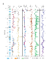
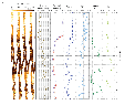
Figure 5.
Formation MicroScanner (FMS)
resistivity images (static
normalization) of depth
intervals 345 - 355 mbsf, 470 -
480 mbsf, and 645 - 655 mbsf
recorded during Expedition 309.
Natural radioactivity,
electrical resistivity (LLD:
LateroLog Deep, LLS: LateroLog
Shallow), density, photoelectric
effect (PEFL), neutron porosity
and capture cross-section
(sigma) are reported on the
right columns. (A) Transition
between the lava pond (Unit 1)
and thin flows (Unit 2) at 348
mbsf. This transition is
characterized by a strong
decrease in the electrical
resistivity. (B) Transition
between a thin flow unit and a
massive unit at 473 mbsf. (C)
Massive unit displaying a marked
increase of the natural
radioactivity at 648 mbsf.
|
Principal rock types distinguished
during Expedition 309 were sheet flows
or brecciated basalts as the most
common, followed by massive units and
pillow basalts. Pillow basalts were only
described in the upper borehole section
between ~365 and 375 mbsf (Figure 4a).
It is evident that highly fractured
lithologies like pillow and brecciated
basalts display higher natural
radioactivity compared to massive units.
These fractured units are also
characterized by variable porosities and
densities with values well above 5 % and
below 2.9 g/cm3,
respectively. Compressional velocities
for these units vary from 3.2 to 5.5
km/s. Pillow basalts may be
distinguished from brecciated
lithologies by resistivities lower than
or equal to ≤10 Ωm. However, a clear
discrimination between these units using
well-logging data alone remains
uncertain. Examples for massive units
are found in depths intervals 316–338
mbsf, ¬472–490 mbsf, 819–833 mbsf, and
1120– 1140 mbsf. These units are clearly
separated from the previous described
lithologies by high compressional
velocities (>5.5 km/s) and densities
(~2.7 g/cm3) and increased
resistivity (usually >100 Ωm), and
correlate with low porosity (< 12%)
and natural gamma ray emissions (<4
gAPI).
The most compelling change in log
response is observed below the
transition zone (~1060 mbsf) in the
sheeted dikes. Natural radiation in
these rocks remains relatively constant
with values generally below 3 gAPI. This
constant value may reflect a change in
stability of K-bearing minerals (e.g.,
saponite), which is essentially the main
carrier of the naturally occurring
radioactivity in these rocks. Increased
bulk density, compressional velocity and
electrical resistivity demonstrate a
clear change in lithology and show the
highest values obtained in Hole 1256D.
Resistivity data recorded with the Dual
LateroLog tool (DLL) demonstrate a
strong decoupling between the shallow
(LLS) and the deep (LLD) resistivity
below 1080 mbsf. Shallow LateroLog
measurements have the same vertical
resolution as the deep LateroLog but
respond more strongly to that region
around the borehole affected by
invasion. Caliper readings from 1080
mbsf to 1211 mbsf are on average 10.98
inches (± 0.5 inch) indicating good
borehole conditions and the shallow
resistivity measurements are
consequently less influenced by fluid
invasion. It is therefore unlikely that
fluid invasion is solely responsible for
the observed decoupling of both
resistivity measurements. Pezard and
Anderson (1989) described this
difference between the shallow and deep
resistivity in ODP Hole 504B and
attributed this to an anisotropic
distribution of pore space in the rock.
In the case of a subvertical network of
conductive fractures the value of the
shallow resistivity is affected more and
consequently more reduced than the deep
resistivity. It is very likely that the
resistivity data obtained in Hole 1256D
also indicate a dominant presence of
vertical features in the sheeted dikes.
Expedition 312 results
Expedition 312 downhole measurements in
Hole 1256D were conducted from a depth
of 1440 mbsf, ~67 m above the total
cored depth (Figure 3
and Figure
4e). Borehole conditions were good
during the six logging runs and provided
high quality data with an excellent
overlap of logging results from
Expedition 309 (Figure 4a,
4b, 4c, and
4d).
Overall results obtained during
Expedition 312 support the division of
the lithology based on core description
from recovered sample material (see: http://iodp.tamu.edu/publications/PR/312PR/312PR.html
for more details). The overall total
gamma-ray is relatively constant and
well below 4 gAPI in the logged
sections. The net measured formation
resistivity increased with increasing
depth but this trend is interrupted at
several depth intervals (Figure 4e).
Strong decoupling between the shallow
and deep resistivity measurements
described at the top of the sheeted
dikes continues to TD. Values for the
shallow and deep resistivity
measurements are in the range of 500
–140000 Ωm. The resistivity data
observed in the sheeted dike complex
suggests that the lithostratigraphy may
be divided into four sections (1060–1155
mbsf, 1155–1275 mbsf, 1275–1350 mbsf,
and 1350–1407 mbsf) based on variability
and magnitude of the electrical
resistivity.
|
|
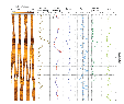
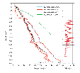
Figure
6. Velocity-depth plot of
Hole 1256D showing wireline
sonic and check-shot interval
velocities from Expedition 312
and Leg 206. Logging and core
bulk density data from Hole
1256D are also shown. The
increase in velocity in the
sheeted to granoblastic dike
boundary to values around 7.0
km/s is apparent.
|
|
|
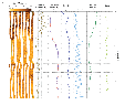
| Figure 7.
Formation MicroScanner (FMS)
resistivity and sonic Ultrasonic
Borehole Imager (UBI) images
(static normalized) showing the
depth range 1402–1409 mbsf
covering the sheeted dike-gabbro
transition described on recovered
samples. FMS data (static
normalized grey scale) obtained
during logging pass 2 (see Figure
3) are overlain the UBI
image for comparison. |
|
|
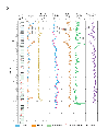
| Figure 8.
Temperature profile of Hole 1256D
recorded by the Temperature
Acceleration Pressure (TAP) and
Environmental Mechanical Sonde
(EMS) tools during Expeditions 309
and 312. Excursions between 900
and 950 mbsf, and 1350 and 1400
mbsf are evident, as is the
temperature increase by nearly
18ºC from beginning to end of the
Expedition 312 bottom hole
temperature measurement. Also
shown are caliper data indicating
good correlation between enlarged
borehole diameter and negative
temperature excursions in some
parts of Hole 1256D (e.g., ~950
mbsf). |
Although, overall density and neutron
porosity range from 1.5–3.1 g/cm3
and 2–75 %, respectively, the variation
remains small in the newly cored section
of Hole 1256D. The average densities of
the sheeted dike complex and the
granoblastic dikes are 2.89 g/cm3
and 2.99 g/cm3, respectively.
Density drops to an average density of
2.95 g/cm3 in Gabbro 1. A
similar drop occurs at a depth of 1407
mbsf where the density decreases from
3.10 g/cm3 to only 2.93 g/cm3.
This change in density is accompanied
with a decrease in compressional
velocity from 6.2 km/s to 4.6 km/s
observed both in wireline and discrete
cube measurements. However, post-cruise
examination of the wireline
compressional velocity data acquired
below 1300 mbsf show discrepancies
between the 3 logging runs. This may be
related to hole conditions and/or tool
movement in the hole and requires
careful re-processing of the obtained
data prior to detailed interpretation.
The VSP was shot in Hole 1256D to
determine interval velocities and to
record seismograms for further analysis
of the seismic properties of upper ocean
crust. In general, the VSP interval
velocities parallel trends in the sonic
log and the shipboard velocity
measurements on recovered rock samples (Figure 6).
Although the velocity magnitude differs
among the various methodologies due to
different frequencies of sound and the
different confining pressures, the
trends with depth are similar. This
similarity demonstrates the fundamental
dependence of velocity fluctuations in
uppermost crust on the primary eruptive
process and the increase in velocity
with depth in ocean velocity layer 2 on
the increasing density of the rocks due
to progressively higher temperature
alteration and metamorphism. However,
there are two unusually high interval
velocities of 7.6 km/s between 1339-1361
mbsf and a velocity of 6.5 km/s at
880-903 mbsf that are not matched by low
velocities at neighboring stations.
Preliminary analysis of the resistivity
and sonic image data (Figure 7)
indicates that directly above the
boundary the formations are
characterized by randomly oriented
fractures, whereas the fractures in the
gabbroic section are regular oriented.
Features observed in the UBI image at
1402 mbsf and 1409 mbsf have a
north-east oriented plunge and an
approximate dip between 35 and 40
degrees and may represent fractures. The
same features are also evident on the
resistivity image where they represent
zones of high conductivity. Bottom hole
temperature was recorded three times (Figure 8)
and an increase from 64.24 ºC to 67.90
ºC, and 86.5 ºC observed in a time frame
of ~5 hrs and 68 ½ hrs, respectively.
Perturbations are visible between
900–950 mbsf and 1350–1400 mbsf with
negative deviation from the temperature
profile. These negative temperature
anomalies indicate a slower return to
equilibrium temperatures and may be due
to a higher influx of seawater invasion
during the drilling process.
|
| References |
Pezard, P.A., and Anderson R.N., 1989.
Proc. ODP, Sci. Results., 111: College
Station, TX (Ocean Drilling Program).
Florence Einaudi: Expedition
309 Logging Staff Scientist,
Laboratoire de Géophysique et
d'Hydrodynamique en Forage, ISTEEM, cc
056, 34095 Montpellier Cedex 5, France
Marc Reichow: Expedition 312
Logging Staff Scientist, University of
Leicester, Borehole Research, Department
of Geology, University of Leicester,
University Road. Leicester, LE1 7RH,
United Kingdom.
|
|
|