Logging Summary
|
| IODP Expedition 311: |
|
Cascadia Margin Gas
Hydrates
Expedition 311
Scientific Party
|
| Introduction |
|
|
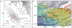
Figure 1. A) Location of IODP
Expedition 311 on the Cascadia
margin. B)
Bathymetry
and location of the different
sites visited (bathimetry
courtesy of D. Kelley, J.
Delaney, and D. Glickson,
University of Washington, and C.
Barnes, C. Katnick, NEPTUNE
Canada, University of Victoria;
funded by the University of
Washington and the W.M. Keck
Foundation).
|
|
|
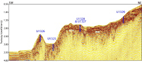
Figure
2. Seismic
section (line 89-08) showing the
position of the Expedition 311
sites across the accretionary
front.
|
Expedition 311 of the Integrated Ocean
Drilling Program (IODP) investigated the
occurence and the formation of gas
hydrate in the accretionary prism of the
northern Cascadia margin. The five sites
visited during the expedition defined a
SW-NE transect across a ~30km wide
Bottom Simulating Reflector (BSR) that
runs parallel to the coast along most of
the continental slope (see Figure 1).
From Site U1326, at the SW tip of the
accretionary prism, to Site U1329, the
shallowest site located at the landward
limit of the BSR, the transect was
designed to sample the complexity of the
evolution of a gas hydrate system (see Figure 2).
To constrain the formation of gas
hydrates in subduction zones, Expedition
311 had an ambitious drilling program
including extensive pressure coring to
recover gas hydrate at in situ
conditions. Because of the unstability
of gas hydrate at surface conditions,
and of the strong response of some
logging tools such as electrical and
acoustic logs to the presence of gas
hydrate, logging was a critical
component of the operations. The logging
program consisted of two phases - the
first week of the expedition was
dedicated to Logging While Drilling
(LWD), in order to identify intervals
likely to contain gas hydrate where
pressure coring tools should be
deployed; the second phase consisted in
wireline logging following coring
operations in order to complete the
geophysical characterization of the
sites. A complete overview of the
expedition results and preliminary
conclusions is available in the Expedition 311
Preliminary Report.
|
|
Logging
Operations
Logging While Drilling/
Measurements While Drilling (LWD/MWD)
|
|
|
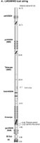
| Figure 3a.
Logging While Drilling/Measurement
While Drilling (LWD/MWD) bottom
hole assembly used during
Expedition 311. |
Following a
strategy that was successfuly
appliedduring ODP Leg 204 on
Hydrate Ridge, offshore Oregon,
the detailed planning of the coring
operations was determined by the LWD
results. The presence and the
distribution of gas hydrate should be
indicated by high resistivity values
in the the resistivity logs and
images.
A number of the
LWD/MWD tools had been used during ODP
Leg 204: Resistivity at Bit (RAB,
GeoVISION); the Azimuthal Density
Neutron tool (adnVISION); the Nuclear
Magnetic Resonance (proVISION); and
the Measurement While Drilling
(TeleScope, an update of the MWD tool
used previously). In addition to these
tools, the LWD/MWD tool string used
during Expedition 311 included the
SonicVISION, which had been used in an
earlier version during ODP Leg 196 in
the Nankai Trough, and the EcoScope,
which had never been used during
ODP/IODP. With all the measurements
provided by the ADN, the EcoScope also
provided several additional
resistivity measurements, elemental
capture spectroscopy, and the borehole
annular pressure while drilling
(APWD). The complete bottom hole
assembly is shown in Figure 3a.
Wireline logging
|
|
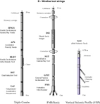
| Figure
3b. Results
Wireline
logging tool strings used
during Expedition 311. Some of
the tools had to be recombined
differently because of
difficult sea states.
|
The planned wireline logging program
included two logging runs for each site:
the triple combo followed by the
FMS/Sonic tool string. The first run was
to provide data similar to some recorded
by the LWD for correlations
(resistivity, density, neutron porosity,
gamma ray), but was also to provide a
caliper log indicating the quality of
the hole for the subsequent run. The
second run with the FMS/Sonic was to
provide high resolution electrical
images, and most importantly for the gas
hydrate characterization, an acoustic
log. Because of difficult sea
conditions, the ship heave often
exceeded the operating range of the
wireline heave compensation system (>
4m), and after damaging a caliper arm
early in the expedition, the wireline
program was limited in several holes to
tool strings devoid of protruding arms.
Despite this constraint, it was possible
to acquire acoustic logs at all sites,
allowing further hydrate
characterization and seismic/well
integration. In addition, two VSP were
acquired as planned in Sites U1327 and
U1328. The tool strings including all
the tools originally planned are shown
in Figure 3b.
The following table summarizes the
variuos tool combinations used during
Expedtion 311.
Water depths
are measured in meters below rig
floor. They were identified during
each tool run by a sharp increase in
measured natural radioactivity gamma
ray when the gamma ray tool crosses
the seafloor.
|
Hole
|
Water depth
(mbrf
|
Max.
dept
(mbsf)
|
Tools
run
|
| 1325A |
2203 |
350 |
GeoVISION/EcoScope/SonicVISION/TeleScope/ProVISION/adnVISION
|
| 1325C |
2205 |
259
185 |
DIT/HNGS
DSI/SGT/TAP |
| U1326A |
1838 |
300 |
GeoVISION/EcoScope/SonicVISION/TeleScope/ProVISION/adnVISION
|
| U1326D |
1838 |
300 |
DIT/DSI/SGT
|
| U1327A |
1316 |
300 |
GeoVISION/EcoScope/SonicVISION/TeleScope/ProVISION/adnVISION
|
| U1327D |
1314 |
295
276 |
DIT/APS/HLDS/HNGS/TAP
WST |
| U1327E |
1313 |
290 |
DIT/DSI/SGT
|
| U1328A |
1278 |
300 |
GeoVISION/EcoScope/SonicVISION/TeleScope/ProVISION/adnVISION |
| U1328C |
1279 |
292
292
285 |
DIT/APS/HLDS/HNGS
FMS/DSI/GPIT/SGT
WST |
| U1329A |
956 |
220 |
GeoVISION/EcoScope/SonicVISION/TeleScope/ProVISION
|
| U1329D |
956 |
10
195 |
DIT/APD/HLDS/HNGS/TAP
FMS/DSI/GPIT/SGT |
Gas monitoring
|
|
| Figure 4. Summary of
the LWD/MWD data used to
monitor for gas. None of the
anomalies observed in the
pressure and waveform
coherence records indicate
any significant amount of
free gas. |
When gas was
detected or expected in previous ODP
cruises, the lack of any blowout
prevention system required a strict
monitoring of the gas composition in
the cores. The monitoring procedure
relied on the analysis of headspace
gas samples after each core was
recovered to decide whether it was
safe to proceed with coring. Because
the LWD/MWD tools were deployed
prior to any coring, the monitoring
for gas was performed by watching
carefully several measurements
transmitted in real time by the MWD
tool: the annular pressure (APWD) and
the sonic waveform coherence. For this
purpose, the SonicVISION was
configured to identify the wave
propagating through the borehole
fluid. The possible occurence of gas
should be indicated by a sharp
pressure decrease, possibly preceded
by a pressure increase, and by a loss
of coherence in the sonic waveforms.
The safety protocol designed for
expedition 311 required preventive
actions for any pressure anomaly
exceeding 100 psi. Figure 4
shows a summary of all the APWD
records, after subtraction of the best
fit linear trends to enhance the
pressure anomalies, and of the sonic
waveforms coherence records. Overall,
it shows that no significant anomaly
was ever detected, allowing to drill
and core each site to its target.
|
| Data and Results |
Overview
We present here a summary of the
logging data and some highlights for
each site visited. Because of hole
instability in the shallower sediments,
wireline data are usually not recorded
in the upper ~60 m. In addition, the
very short time elapsed after the
initial formation penetration makes LWD
measurements much less affected by
borehole degradation than wireline logs.
Therefore, we use the LWD measurements
preferably for data that were recorded
by both sets of tools, such as density
and porosity. For still unexplained
reasons, the LWD gamma ray readings were
generally higher than the wireline data
and we display both curves for
completeness.
Despite the proximity of the holes in
any site, the considerable heterogeneity
in lithology and gas hydrate
distribution results in apparent
discrepancies between the LWD and
wireline data. Some of these
discrepancies are discussed in greater
details for individual sites. Finally,
we have added to each figure the
compilation of the infrared images (IR)
recorded in each site. These images,
recorded immediately after core
recovery, were the primary means onboard
to identify and isolate gas hydrate
samples, which were associated with cold
anomalies due to the endothermic nature
of gas hydrate dissociation.
The data are presented from the most
seaward site (U1326), following the
transect upward the deformation front to
the most landward site (U1329) (see
Figures 1
and 2 for
locations).
Water saturations
Preliminary estimates of the amounts of
gas hydrate are also given in these
figures, expressed as water saturation.
Since the primary conductor of electric
current in the formation is the pore
water, its substitution by electrically
insulating gas hydrate generates
resistivity anomalies that can be used
to estimate the fraction of the pore
space occupied by water, or water
saturation (Sw). Archie (1942) defined a
relationship to estimate water
saturation from resistivity and porosity
logs in traditional hydrocarbon
reservoirs, and Collett (1998) has shown
that the same relationship can be used
in the presence of gas hydrate. The gas
hydrate saturation (Sh) can be assumed
to be the complement of Sw (i.e. Sh = 1
- Sw) within the gas hydrate stability
field. (see the Initial reports of ODP
Leg 204 for a complete
description). For each site, a value for
the cementation exponent (m) in the
Archie relationship was estimated from
Archiees equation using the resistivity
and porosity logs and salinity values
measured on core samples, with the
Archie coefficient (a) and the
saturation exponent (n) were assumed to
be 1 and 2, respectively.
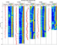
Site U1326
|
|
| Figure 5. Summary of the
logging data recorded at Site
U1326. In the resistivity
column, the Deep Induction and
SFLU (Spherically Focussed Log
Unfiltered) curves were
recorded with the wireline
tools, the others with LWD.
The last column on the right
is a compilation of the Infra
Red (IR) images recorded on
the core liner of the
recovered sections to detect
gas hydrate. |
Located at the SW end of the Expedition
311 transect, Site U1326 was drilled Êon
an uplifted ridge of accreted sediments.
This site was the last one visited for
coring and wireline logging operations.
Because of time constraints and concerns
about an upcoming storm, wireline
operations were limited to a single run
with a tool string composed of the Gamma
Ray/Resistivity/Sonic tools
(SGT/DIT/DSI). A summary of the data
recorded in this site is shown in Figure 5.
The most significant feature in the LWD
data is a ~20m interval above 100 mbsf,
characterized by bright RAB images and
high resistivity values (Phase shift 16
in and Button deep average). The
wireline resistivity curves (deep
induction and SFLU) and the
compressional velocity log (Vp) almost
parallel each other in this interval,
following a pattern identical to the LWD
resistivity, but ~10 m shallower. The
high resistivity and Vp values, while
density or porosity do not change,
suggest significant amounts of gas
hydrate, but the offset between the two
holes indicates significant lateral
heterogeneity. Indeed, the water
saturation is possibly as low as 40%
between 80 and 90 mbsf in Hole U1326A,
but steeply dipping features identified
in the RAB images show that gas hydrate
is present in beds dipping by as much as
85¡, indicating the sediment deformation
in this ridge at the tip of the
accretionary prism.
Below ~100 mbsf, the uniformly low
resistivity values suggest that only
little, if any, gas hydrate is present,
except for Êa ~2m interval above 260
mbsf in Hole U1326A. This interval
coincides with a loss in sonic waveform
coherence in the LWD monitoring data
(see Figure 4), that could be associated
with free gas.
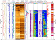
Site U1325
|
|
Figure
6. ummary of the
logging data recorded at Site
U1325. In the resistivity
column, the Deep Induction and
SFLU (Spherically Focussed Log
Unfiltered) curves were
recorded with the wireline
tools, the others with LWD.
The last column on the right
is a compilation of the Infra
Red (IR) images recorded on
the core liner of the
recovered sections to detect
gas
hydrate.
|
|
|
Figure
7. Summary of the
logging data recorded at Site
U1327. In the resistivity
column, the Deep Induction and
SFLU (Spherically Focussed Log
Unfiltered) curves were
recorded with the wireline
tools, the others with LWD.
The comparison of the Infra
Red (IR) images from Hole
U1327C and U1327D with the
resistivity logs acquired in
Holes U1327A, U1327D and
U1327E illustrates the strong
lateral heterogeneity of gas
hydrate distribution at this
site.
|
Site U1325 was drilled in
a slope basin located seaward of
of the deformation front, behind
the ridge of accreted sediments
drilled in U1326 (see Figure 1).
This site was the
first one visited by Expedition
311, and a strict application of
the safety protocol guidelines
resulted in excessive pumping
rate and poor data in the first
20 m of Hole U1325A. Pumping rates were
subsequently reduced at the time
of spud-in for the following
sites, while maintaining the
capability to monitor the safety
of the drilling operations.
Because of difficult sea state,
wireline operations were limited
to two strings without arms
(HNGS/DIT and SGT/DSI). Rapidly
deteriorating hole conditions
prevented the recording of
acoustic data below 175 mbsf.
A summary of the logging
data is shown in Figure 6.
The highly
variable resistivity log and the
succession of dark and bright layers
in the RAB image show that gas
hydrate may be present in a series
of thin layers alternating with
gas-hydrate-free sediments. The most
distinct occurrences, between 175
and 240 mbsf, result in water
saturation values as low as 40 %.
Unfortunately, no acoustic data
could be recorded in this interval.
However, because of the location of
this site in an undisturbed basin,
the wireline and LWD logs agree very
well over the entire interval
logged, and tend to confirm the
finely layered distribution of gas
hydrate.
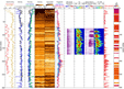
Site U1327
Site U1327 was
drilled near ODP Site 889, where the
largest amounts of gas hydrate had been
identified during ODP Leg 146. While LWD
operations proceeded without any
trouble, the wireline logging program
encountered several drawbacks due to bad
sea conditions. At the end of the first
triple combo run in Hole U1327D, during
which heave was measured at ~3.5 m, the
HLDS caliper arm was damaged, and the
subsequent Vertical Seismic Profile
(VSP) also resulted in damage to
the WST tool. Despite these
difficulties, the data recorded were of
good quality, but it was necessary to
drill a new hole, U1327E, in order to
acquire an acoustic log, crucial for the
complete characterization of the gas
hydrate distribution. The arm-free tool
string used in Hole U1327E did not meet
any further obstacles. A summary of the
data collected in Site U1327 is shown in
Figure 7.
As in Hole
U1326A, the most striking feature in
the data recorded in Hole U1327A is a
high resistivity 20-meter thick
interval, showing as a bright lawyer
between 120 and 140 mbsf in the RAB
image, which was interpreted as a
significant occurence of gas hydrate.
The water saturation estimate suggest
that gas hydrate occupies up to 60% of
the pore space in this interval.
However, the different pressure coring
tools deployed in the same interval in
adjacent Hole U1327C failed to recover
any gas hydrate, and the IR images
recorded on the cores from Hole U1327C
suggested that the main occurrence of
gas hydrate in this hole was ~20
m deeper than in Hole U1327A. The
subsequent IR images in Hole U1327D
and wireline resistivity logs in Holes
U1327D and U1327E showed more
heterogeneity in gas hydrate
distribution, the only agreement being
between the log data and IR images
recorded in the same hole (U1327D).
Overall, the combination of the logs
and IR images suggest that some
amounts of gas hydrate is present in
all the holes between 80 and 240 mbsf,
but this distribution seems to be
different in every
hole.
VSP The original
plan for the VSP was to acquire a high
resolution survey with only 5 meters
between each station over the entire
hole. Difficult sea conditions and an
enlarged hole did not allow us to
record more than 16 stations in Hole
U1327D, none shallower than 182 mbsf.
The results of the VSP in Hole U1327D
are shown in Figure
8.
|
|
|
Figure
8. VSP
results in Hole U1327D. A) Stacked
traces with original
automated travel time
picks. B)
Corrected picks. The two
lines indicate least
square linear fit to the
data above and below the
BSR. C)
Comparison of the VSP
inversion results with the
sonic log recorded in Hole
U1327E and the inversion
performed on the VSP data
from Hole 889B.
|
|
|
| Figure
9. Summary of the
logging data recorded at Site
U1328. In the resistivity
column, the Deep Induction and
SFLU (Spherically Focussed Log
Unfiltered) curves were
recorded with the wireline
tools, the others with LWD.
The last column on the right
is a compilation of the Infra
Red (IR) images recorded on
the core liner of the
recovered sections to detect
gas hydrate.
|
The primary purpose of the VSP was to
define an accurate time vs. depth
relationship to tie precisely the well
data with the seismic line crossing the
site. The arrival times picked in the
stacked traces in Figure 8a,
after correction for firing delays and
tool position, define two distinct
velocity trends above and below ~250
mbsf in Figure
8b. The contrast between the
higher velocity above and lower velocity
below, presumably corresponding to the
occurrence of gas hydrate and free gas,
respectively, causes the BSR observed in
this site. Figure
8c shows the results of a Bayesian
inversion of these data (see Malinverno
and Briggs, 2004), giving a more
complete picture of the velocity changes
at the origin of the BSR. The comparison
with logging and VSP data in nearby
Holes U1327E and 889B shows that the
velocity transition zone responsible for
the BSR occurs at different depths
despite the proximity of the holes
(U1327D and U1327E are ~15 meters apart.
Hole 889B is ~500m to the west).
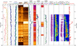
Site U1328
Located slightly offset from the
expedition transect (see Figure 1),
Site U1328 was drilled to investigate an
active cold vent system, where focused
fluid flow is feeding the formation of
massive near-seafloor gas hydrate and the
growth of chemosynthetic communities. The
vents are identified by blank zones in the
seismic data, whose origin was one of the
questions to answer at this site. The
sea remained calm during the
operations, allowing the full wireline
program to be completed in Hole U1328C,
including the triple combo, the FMS/Sonic
and the VSP. A summary of the data
collected in Site U1328 is shown in Figure 9.
The LWD data
recorded in Hole U1328A show the
highest concentrations of gas hydrate
encountered during Expedition 311. The
water saturation derived from the LWD
resistivity drops below 20% in
intervals between 5 and 20 mbsf,
indicating that gas hydrate could
occupy more than 80% of the pore
space. The RAB images show that some
of the highest concentrations occur
within steeply dipping fractures that
act as conduits feeding the near
surface gas hydrate accumulation. Gas
hydrate concentrations then decrease
with depth and gas hydrate is only
sparsely present below 50 mbsf, in
particular within a thin
hydrate-filled steep fracture at ~95
mbsf.
VSP A clement
weather and good hole conditions
allowed to record stations every 5
meters over most of the open interval
in Hole U1328C, with 35 stations
recorded successfully between 286 and
106 mbsf. Apparent interference from
the pipe and/or the wireline prevented
from recording any meaningful signal
at shallower depths. The results are
shown in Figure
10.
|
|
|
Figure 10.
VSP results
in Hole U1328C.
A)
Stacked traces with original
automated picks. B)
Corrected picks. The red
line indicates the least
square linear fit for the
entire data set. C)
Comparison of the Bayesian
inversion results with the
two passes of the sonic log
recorded in the same hole.
|
|
|
Figure
11. Summary
of the logging data recorded
at Site U1329. In the
resistivity column, the Deep
Induction and SFLU
(Spherically Focussed Log
Unfiltered) curves were
recorded with the wireline
tools, the others with LWD.
The last column on the right
is a compilation of the
Infra Red (IR) images
recorded on the core liner
of the recovered sections to
detect gas hydrate.
|
The
5 meters spacing provided a high
resolution image of the velocity
structure in this seismically 'blank'
area, and both the time vs. depth
relationship (Figure
10b) and the results of the
Bayesian inversion (Fig 10c)
show low velocity values and a very
low variability that are consistent
with the low seismic reflectivity. The
comparison with the Vp logs recorded
during two passes in the same hole
confirm these results.
Site U1329
At the shallowest water depth
encountered during our operations, Site
U1329 marks the landward end of the
Expedition 311 transect, at the NE edge
of the regional gas hydrate
occurrence (see Figure 1).
While it was the last site drilled with
the LWD/MWD tools, it was also the first
one for coring and wireline logging
operations. All scheduled logging
operations proceeded without incidents,
but the wireline logs in Hole U1329D
revealed an enlarged hole over most of
the open interval, impairing the quality
of the data. A summary of the data
collected in Site U1329 is shown in Figure 11.
As
expected from its location at the
limit of the regional area of gas
hydrate occurrence, the logging data
recorded in Site U1329 reveal only
little, if any, gas hydrate in the
sediments penetrated at this site.
The data are characterized by
a gradual increase in density and
resistivity with depth, with a
marked sharpening of the trend at
165 mbsf and then at 185 mbsf. The
high resistivity below this depth,
illustrated by the bright RAB
images, and combined with high
density and low porosity, is the
indication of increasingly
consolidated sediments, possibly
composed of thick debris flows.
Unfortunately, the low core recovery
in this extremely indurated
formation did not allow us to fully
characterize the nature of this
interval.
|
| Summary |
These
results are still preliminary, and
much remains to be learned from the
data recorded during Expedition 311,
but a few conclusions can be already
drawn at this stage:
(1)
As part of an adequate protocol, the
LWD/MWD tools provide a safe and
reliable way to monitor the occurrence
of free gas, flows, or other drilling
hazards.
(2)
The use of LWD tools to help identify
targets for pressure coring tools was
again a valuable strategy to optimize
the recovery of gas hydrate. However,
this strategy has to be considered
carefully in highly heterogenous
settings such as accretionary
complexes.
(3)
The combined interpretation of the LWD
and wireline data along the Expedition
311 transect, particularly of the
resistivity and acoustic data,
provides a rich picture of the complex
distribution of gas hydrate across the
Cascadia margin. These preliminary
results suggest in particular that,
except for short 'anomalous'
intervals, gas hydrate concentrations
are generally lower than previously
estimated from ODP Leg 146. One of the
primary objectives of the upcoming
work will be to calibrate the
different methods to quantify
accurately the amounts of gas hydrate
identified from the logs.
References
Collett, T.S., Well log evaluation of
gas hydrate saturations, Trans. SPWLA
39th Logging Symposium, paper MM
1998.Malinverno, A. and Briggs, V.A.,
2004. Expanded uncertainty
quantification in inverse problems:
Hierarchical Bayes and empirical Bayes.
Geophysics, 69: 1005-1016.
|
Gilles Guerin: Logging Staff
Scientist, Borehole Research Group,
Lamont-Doherty Earth Observatory of
Columbia University, PO Box 1000, 61
Route 9W, Palisades, NY 10964, USA
Alberto Malinverno: Logging
Staff Scientist, Borehole Research
Group, Lamont-Doherty Earth Observatory
of Columbia University, PO Box 1000, 61
Route 9W, Palisades NY 10964, USA
Greg Myers: LWD
LoggingScientist, Borehole Research
Group, Lamont-Doherty Earth Observatory
of Columbia University, PO Box 1000, 61
Route 9W, Palisades, NY 10964, USA
Peter Jackson : Logging
Scientist, Geophysics and Marine,
British Geological Survey, Kingsley
Dunham Centre, Keyworth, Nottingham NG12
5GG, UK
|
|
|