Logging Summary
|
| IODP Expedition 317: |
|
Canterbury Basin Sea Level
Expedition 317
Scientific Party
|
| Introduction |
|
|
|
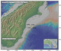
Figure 1.
Location of IODP Expedition 317
off the east coast of the South
Island of New Zealand.
|
|
|
|
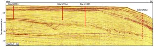
Figure 2.
Seismic line (EW00-01-66)
showing the position of
Expedition 317 sites along the
shelf-to-slope transect. Site
U1352 (dashed line), located
~5.8 km northwest of Line 66, is
projected onto the line.
|
The primary objective of Expedition 317
was to understand the relative
importance of global sea level versus
local tectonic and sedimentary processes
in controlling sedimentary cycles on the
continental margin. The expedition
recovered sediments from the Eocene to
recent period, with a particular focus
on the sequence stratigraphy of the late
Miocene to recent, when global sea level
change was dominated by glacioeustasy.
The Canterbury Basin, off the South
Island of New Zealand, provides a unique
environment to study the complex
interactions between sedimentary
processes because of the proximity of an
uplifting mountain chain (the Southern
Alps), high rates of sediment supply,
and strong ocean currents.
During Expedition 317, a shelf-to-slope
transect of four sites was drilled in
the Canterbury Basin (see Figure 1).
The transect provides access to a
stratigraphic record of depositional
cycles across the shallow-water
environment , which is most directly
affected by relative sea level changes
(see Figure 2).
Lithologic boundaries and significant
downhole variations that are
provisionally correlative with seismic
sequence boundaries have been identified
in the three continental shelf sites
(landward to basinward, Sites U1353,
U1354, and U1351) and slope Site U1352.
These data will be used to estimate the
timing and amplitude of past global sea
level changes and to document the
sedimentary processes that operate
during sequence formation, as well as
providing insights into the origins of
seismically resolvable sequences.
One of the primary objectives of the
logging program was to provide precise
seismic-well correlations to constrain
the seismic stratigraphy of the
Canterbury Basin. Logging data were also
critical for identifying the nature of
key seismic reflections and
unconformities, which could potentially
coincide with intervals that would be
difficult to recover using standard
coring techniques.
A complete overview of the expedition
operations and preliminary scientific
results is available in the Expedition 317
Preliminary Report.
|
|
Logging Tools
and Operations
|
|
|
|
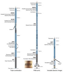
Figure
3. Logging tool
strings planned for Expedition
317. Some of the tool strings
were reduced or reconfigured
during the expedition, due to
difficult hole conditions.
|
The planned logging program included
three logging tool strings for each
site: the triple combo, the FMS/Sonic
tool string, and the VSI tool string for
vertical seismic profiles. Figure 3
shows the tool strings originally
planned for deployment at the four
primary sites of Expedition 317.
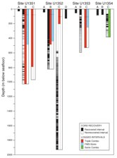
Six holes were logged during Expedition
317: Holes U1351B, U1351C, U1352B,
U1352C, U1353C, and U1354C. Hole
preparation consisted of sweeping the
hole with high-viscosity
sepiolite/attapulgite mud, circulating
twice the volume of the hole, and
displacing the hole with mud or
seawater. Borehole conditions were
unstable at all drilled sites,
particularly in the shallow intervals
dominated by unconsolidated sand- and
shell-rich sediments. As a result of
collapsing and obstructed boreholes,
many of the logging runs were unable to
reach total depth and tool strings
became stuck in two of the six holes
logged (Holes U1351C and U1353C). The
logged intervals at each site, compared
to the total borehole depths, are shown
in Figure 4.
|
|
|
Figure
4. Logged intervals
and tool strings run for each
hole during Expedition 317.
Intervals include logging
through drill pipe between the
seafloor and the drill bit, for
which only gamma ray data is
reliable. Pipe depth for each
hole is indicated by horizontal
dashed line.
|
The triple combo and FMS/Sonic tool
strings were run in at least one hole at
Sites U1351, U1352, and U1353. Because
of unstable hole conditions, the triple
combo was run without radioactive
sources in two holes, so no density or
neutron porosity logs were recorded in
these holes. A single modified tool
string, the Sonic combo, was run at Site
U1354 due to the potential for unstable
hole conditions and limited time at the
end of the expedition. Because of
unstable hole conditions and large
borehole diameters at all sites, it was
not feasible to deploy the VSI tool
string, which requires the tool to be
firmly anchored against the borehole
wall to record good waveforms.
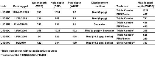
The following table summarizes logging
operations carried out during the
expedition.
|
| Data and Results |
Overview
We present here a summary of logging
data collected during this expedition
and show some highlights for each site.
The base of the drill pipe was lowered
to ~80-100 meters below the seafloor
prior to logging, so wireline logs are
generally recorded only below this
depth. Although logging data are
initially referenced to depth below the
rig floor (WRF), after logging is
completed, all data are shifted to a sea
floor reference and depth-matched to
remove offsets between different logging
runs. The resulting depth scale is
wireline matched depth below sea floor
(WMSF) and all log data presented here
are in meters WMSF.
Porosity and density from
resistivity
In order to provide a measure of
porosity and density for sites where
poor hole conditions adversely affected
density and neutron porosity
measurements (U1352) or where the triple
combo was run without radioactive
sources (U1353 and U1354), we used
Archie’s (1942) relationship to
calculate porosity. Although electrical
resistivity is not a direct measurement
of porosity, it is highly sensitive to
the presence of formation fluid and,
therefore, to bulk porosity. Archie
(1942) established an empirical
relationship between porosity, formation
resistivity, and pore water resistivity
in sandy formations, but it has also
been successfully used to estimate
porosity in clay-rich formations with
poor borehole conditions (Jarrard et
al., 1989; Collett, 1998). For
Expedition 317, porosity was calculated
from the deep induction resistivity log
(IDPH), because it is the log least
affected by borehole conditions
(Schlumberger, 1989), and combined with
grain density from moisture and density
(MAD) measurements on cores to derive a
more reliable density profile.
See the Proceedings of IODP
Expedition 317 for a complete
description of calculations for each
site, including values for Archie
coefficients and temperature and
salinity estimations.
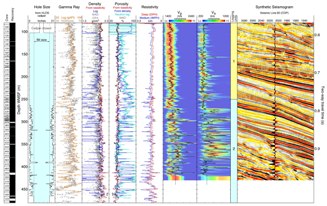
Synthetic seismograms
In order to correlate features in
seismic stratigraphy, recorded in the
time domain, to features in cores and
logs, recorded in the depth domain, a
time-depth relationship must be
determined at each site. The time-depth
relationship can be estimated by
constructing synthetic seismograms,
which are computed from reflection
coefficients obtained from contrasts in
compressional wave velocity and density,
to match the seismic traces nearest to
the borehole. Synthetic seismograms were
constructed for sites where shipboard
sonic logs provided reliable
compressional wave velocity (U1352,
U1353, and U1354), using the IESX
seismic interpretation package (part of
the Schlumberger GeoFrame software
suite). Typically, the synthetic
seismograms provided a very good match
with reflections interpreted as sequence
boundaries in the seismic stratigraphy,
as shown in site figures.
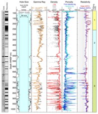
Site U1351
|
|
|
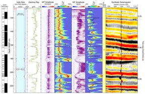
Figure 5.
Summary of logging data recorded
with the Triple Combo at Site
U1351.
|
|
|
| Figure
6. Summary of logging data
recorded with the FMS/Sonic at
Site U1351. |
Site U1351 was drilled as the deepest
of three sites on the continental shelf,
at 122 meters water depth. The primary
objective at this site was to sample
facies just landward of clinoform
breakpoints in progradational seismic
sequence boundaries, linking shelf and
slope unconformities (middle Miocene to
Holocene). Core recovery in the three
holes drilled at this site ranged from
30% to 98%, with lowest recovery deeper
than ~80 meters below sea floor.
Sediments recovered at this site
correspond to two lithologic units: Unit
I (0-262 mbsf), consisting of mud and
sandy mud with lesser amounts of shell
hash and sand; and Unit II (262-1024
mbsf), consisting of sandy mud and muddy
sand with lesser amounts of sand and
shell hash.
Downhole logs were recorded in Holes
U1351B and logging-dedicated U1351C. The
caliper logs recorded by the HLDS and
FMS at this site show that the borehole
was significantly larger than bit size
above ~500 WMSF and less enlarged but
very irregular below ~500 WMSF (see Figure 5 and
Figure 6).
Comparison of measurements between Holes
U1352B and U1352C show very good
agreement, even in the enlarged upper
half of the hole, indicating that the
density log was not seriously affected
by the hole condition. Below ~620 WMSF,
none of the questionable low gamma ray
and resistivity excursions in Hole
U1351B are matched in Hole U1351C,
suggesting that they resulted from the
irregular hole in the deeper section of
Hole U1351B. High coherence in sonic
logs suggests that the DSI should
provide reliable velocity values;
however, the automatic labeling of wave
arrivals failed to recognize the
compressional wave in some intervals.
Additional post-cruise processing should
correct these curves and allow for the
construction of a synthetic seismogram.
Three logging units were identified at
this site, based on subtle changes in
trends and characteristic features.
Logging Unit 1 (83-260 WMSF) is
characterized by relatively
high-amplitude variations in gamma ray,
with low gamma ray excursions
corresponding to intervals with high
resistivity and sonic velocity values.
These are likely sand- and/or shell-rich
layers, which is consistent with poor
core recovery in these intervals. The
overall log signature in this unit is
indicative of alternating shelly or
sandy beds and clay-rich beds. Logging
Unit 2 (260-510 WMSF) is defined by
low-amplitude variability and decreasing
trends with depth in gamma ray and
resisitivity. Three distinct intervals
of increasing upward gamma ray within
this unit suggest fining-upward
subunits. Caliper readings consistently
larger than 18.5 inches in Units 1 and 2
suggest that the formation has little
cohesion. The top of Logging Unit 3
(510-1031 WMSF) is defined by a
significant increase in gamma ray,
accompanied by increases in density and
resistivity. Below a ~50 m thick
interval with high gamma ray, density,
and resistivity values, the logs are
variable and without clear trends.
Logging Unit 3 corresponds to an
interval where the borehole diameter is
slightly smaller than in the upper
units, suggesting more consolidated or
cohesive sediments.
Site U1352
|
|
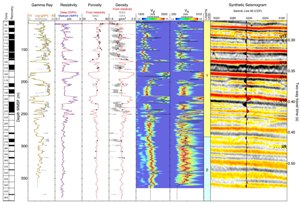
Figure
7. Summary of logging
data recorded at Site U1352.
|
The critical objectives of drilling at
Site U1352 (at 344 meters water depth)
were to sample slope facies of seismic
sequence boundaries (middle Miocene to
Holocene) as well as the Marshall
Paraconformity, interpreted to be the
result of intensified current erosion in
the early Oligocene that accompanied the
initiation of thermohaline circulation
and the proto Antarctic Circumpolar
Current following the separation of
Australia and Antarctica. Core recovery
was ~100% in the two shallow holes
(<130 m penetration) and ranged from
51% to 74% in the two deep holes drilled
at this site. Sediments recovered at
this site correspond to three lithologic
units: Unit I (0-711 mbsf), consisting
of calcareous sandy mud, interbedded
sandy mud and clay, interbedded sand and
mud, massive sand, mottled sandy mud,
homogenous mud, sandy mud, and marl;
Unit II (711-1853 mbsf), consisting of
calcareous sandy mud, sandy marls,
chalk, sandy marlstone, and sandy
limestone; and Unit III (1853-1924
mbsf), consisting of pelagic
foraminifera-bearing nannofossil
limestone.
Downhole logs were recorded in Holes
U1352B and U1352C. Caliper logs
from this site suggest an enlarged and
irregular borehole for the entire logged
interval (see
Figure 7). Measurements from the
two orthogonal FMS calipers suggest that
the borehole cross-section was not
circular, but likely elliptical below
~270 WMSF. Despite the enlarged
borehole, comparison between gamma ray
logs and natural gamma ray (NGR)
measurements made on cores from Hole
U1352B shows generally good agreement.
However, the density log is seriously
affected by the hole conditions, shown
by the lack of agreement between logs
and MAD core measurements. High
coherence in the sonic waveforms
suggests that the DSI data should
provide reliable compressional and shear
velocity values.
The combined analysis of the logs
allows for the identification of two
logging units at this site, based on
characteristic trends. Logging Unit 1
(82-250 WMSF) is characterized by
relatively low-amplitude variations in
gamma ray, resistivity, and acoustic
velocities. There is a distinct
increasing-upward trend in gamma ray
from 250 WMSF up to a high gamma ray
interval between 160-170 WMSF, which
corresponds to an interval of
homogeneous mud with clay beds in cores
from Hole U1352B. Gamma ray values
decrease upward above ~160 WMSF, which
may reflect a generally decreasing clay
content in this depth interval. The
increasing-upward and then
decreasing-upward pattern in gamma ray
is consistent with gamma ray logs from
an equivalent depth at nearby ODP Site
1119 (Shipboard Scientific Party, 1999).
Logging Unit 2 (250-487 WMSF) is defined
by a change to higher-amplitude
variations in gamma ray, resistivity,
and acoustic velocities. Gamma ray and
velocity increase with depth. The
borehole diameter in this unit is
smaller but highly irregular, which may
reflect the presence of more cohesive
marls in the formation.
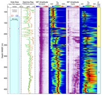
Site
U1353
Site U1353 was the shallowest site
drilled on the continental shelf, at 85
meters water depth. The primary
objective of drilling at this site was
to sample facies landward of clinoform
breakpoints of seismic sequence
boundaries, particularly the older
unconformities (middle Miocene to
Pliocene). Core recovery ranged from
~100% in the shallow hole (<60 m
penetration) to 34% in the deep cored
hole at this site. Sediments drilled at
this site correspond to two lithologic
units: Unit I (0-151 mbsf), consisting
of mud with minor amounts of very fine
sand, and Unit II (151-614 mbsf),
consisting of very fine sandy mud and
mud, typically with shells.
Downhole logs were recorded in
logging-dedicated Hole U1353C. While
caliper logs from both HLDS and FMS
indicate an enlarged and irregular
borehole, all calipers maintained
relatively good contact with the
formation above ~350 WMSF and suggest
that recorded data should be of good
quality (see Figure
8 and Figure
9). Below this depth, hole
diameter is close to the maximum reach
of the HLDS caliper. The closely matched
overlay between the two resistivity
measurements with deep and medium depths
of penetration indicates that the
resistivity log is of good quality.
Comparison of the gamma ray log with NGR
core data also shows significant
agreement, indicating good quality gamma
ray log values. Clear arrivals and high
coherence patterns in sonic logs
indicate that the DSI should provide
reliable velocity values.
Two logging units were identified,
based on combined analysis of the logs.
Logging Unit 1 (105-260 WMSF) is
characterized by an increasing-upward
trend in gamma ray between ~250 and 180
WMSF, followed by a generally
decreasing-upward trend from 180 WMSF to
the top of the unit. These trends are
interrupted by abrupt high-amplitude
lows in gamma ray and peaks in
resistivity and velocity that are
interpreted as sandy intervals, many of
which coincide with sand or gravel at
corresponding depths in cored Hole
U1353B. These features also show good
correspondence with significant seismic
reflections (see Figure 9).
Logging Unit 2 (260-528 WMSF) is
characterized by overall decreasing
trends with depth in gamma ray and
resistivity, with low variability. The
top of the unit is roughly the same
depth as the onset of low core recovery
in Hole U1353B and the point at which
the FMS/Sonic tool string encountered an
impassable obstruction, suggesting a
change in the properties of the
formation across the unit boundary.
Site U1354
Site U1354, an intermediate depth shelf
site at 120 meters water depth, was
drilled with the primary objective of
sampling facies landward of breakpoints
of seismic sequence boundaries,
particularly near the breakpoints of
several late Miocene to Pliocene
unconformities. Core recovery ranged
from ~100% in shallow holes (<90 m
penetration) to 42% in the deeper hole.
Sediments drilled at this site
correspond to two lithologic units: Unit
I (0-251 mbsf), consisting of calcareous
muddy sand, sandy marl, and homogenous
marl and very well-sorted very fine to
fine sand; and Unit II (251- 375 mbsf),
consisting of very fine sandy mud and
mud, typically with shells.
|
|
| Figure
10. Summary of logging
data recorded with the Sonic Combo
at Site U1354. |
Downhole logs were
recorded in Hole U1354C with a single,
modified tool string (dubbed the “Sonic
Combo”, HNGS/DSI/GPIT/DIT), due to the
potential for unstable hole conditions
and time constraints at the end of the
expedition. No caliper was run in this
toolstring, but data quality was
assessed by looking at correlations
between different measurements, internal
consistency, and comparisons between
logs and core measurements. Significant
increases in resistivity and velocity
are accompanied by negative gamma ray
excursions (see Figure 10),
indicating that those intervals were
likely consolidated sand-rich layers and
that the changes in gamma ray represent
valid lithology changes rather than
intervals of enlarged borehole. A
comparison with logs recorded at other
shelf sites (Sites U1351 and U1353) also
shows that the trends in gamma ray can
be visually correlated across the shelf,
indicating the good quality of logs
recorded in Hole U1354C. There is a
reasonable agreement between the gamma
ray logs and NGR measurements on cores
from Hole U1354C. The good agreement
between the deep-penetration and
medium-penetration resistivity curves is
yet another indication that the borehole
diameter was not anomalously large or
irregular.
The combined analysis of logs was used
to identify two logging units defined by
characteristic trends. Logging Unit 1
(110-285 WMSF) is characterized by an
increasing trend in gamma ray from the
top of the unit to ~185 WMSF, followed
by a generally decreasing trend to the
base of the unit, punctuated by abrupt
high-amplitude lows in gamma ray and
peaks in resistivity and velocity. This
unit is identical to Logging Unit 1 at
Site U1353 and the high-amplitude
features at both sites correspond to
coarser-grained intervals in cores.
Preliminary synthetic seismograms show
that the two most prominent of these
sand-rich intervals coincide with
seismic reflectors U10 and U11. Logging
Unit 2 (285-384 WMSF) is characterized
by slightly decreasing trends in gamma
ray and resistivity, with limited
variability, and increasing velocity. It
is similar to Logging Unit 2 at Site
U1353, which is characterized by low
core recovery associated with sandy
sediments.
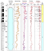
Log-Seismic Correlations
|
|
|
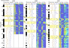
Figure
11. Natural gamma
ray, electrical resistivity, and
sonic logs at Sites U1353,
U1354, and U1351. Correlations
between seismic sequence
boundaries (U10-U13) and logs
are highlighted in yellow
intervals. In particular, U10
through U12 are distinct
features in the logging data,
characterized by low gamma
radiation, high resistivity, and
increased Vp and Vs, that can be
correlated across the three
shelf sites. Sonic logs from all
three sites have been
preliminarily reprocessed
(Guerin, postcruise research).
GR – gamma radiation; IDPH –
deep induction resistivity log.
|
Repeated trends in gamma ray,
resistivity, and velocity logs in the
upper ~300 meters below sea floor across
the three shelf sites (landward to
basinward, U1353, U1354, and U1351)
strongly support the continuity of
seismic stratigraphy across the
continental shelf. Figure 11
shows a preliminary site-to-site
correlation between logs and seismic
sequence boundaries. These correlations
are supported by good agreement between
distinct seismic reflections (U10-U12)
and synthetic seismograms at Sites U1353
and U1354 (Figures
9 and 10,
respectively). Strong coherence patterns
in velocity logs from shelf Site U1351 (Figure 6),
which were not properly labeled by the
shipboard algorithm, suggest that the
corresponding sequence boundaries will
also be apparent at Site U1351 when the
sonic logs are reprocessed. Logs were
recorded in younger sediments at slope
Site U1352 and post-cruise analysis of
synthetics may lead to correlations with
younger seismic sequence boundaries
(U14-U19).
|
References
|
Archie, G.E., 1942. The electrical
resistivity log as an aid in determining
some reservoir characteristics, J.
Pet. Technol., 5, 1-8.
Collett, T.S., 1998. Well log
evaluation of gas hydrate saturations, Trans.
SPWLA Annual Logging Symp.,
39, paper MM.
Jarrard, R.D., Dadey, K.A., and Busch,
W.H., 1989. Velocity and density of
sediments of Eirik Ridge, Labrador Sea:
control by porosity and mineralogy, Proc.
ODP, Sci. Res., 105, College
Station, TX (Ocean Drilling Program),
811-835.
Schlumberger, 1989. Log
Interpretation Principles/Applications:
Houston (Schlumberger Educ. Services),
SMP–7017.
Shipboard Scientific Party, 1999. Site
1119: Drift Accretion on Canterbury
Slope. In Carter, R.M.,
McCave, I.N., Richter, C., Carter, L.,
et al., Proc. ODP, Init. Repts., 181,
College Station, TX (Ocean Drilling
Program), 1-112.
|
Angela Slagle: Logging
Staff Scientist, Borehole Research Group
Lamont-Doherty Earth Observatory of
Columbia University, PO Box 1000, 61
Route 9W, Palisades, NY 10964, USA
Saneatsu Saito:
Logging Scientist, Institute for
Frontier Research on Earth Evolution
(IFREE), Japan Agency for Marine-Earth
Science and Technology (JAMSTEC), 2-15
Natsushima-cho, Yokosuka 237-0061 Japan
|
|
|