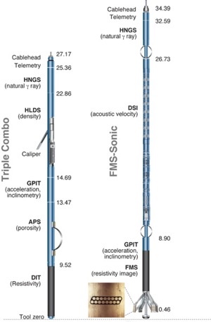
Logging Summary
|
|||||||||||||||||||||||||||||||||||||||||||
| Data and Results | |||||||||||||||||||||||||||||||||||||||||||
|
Overview We present here a summary of the logging data and some highlights for each site visited. Because of hole instability in the shallower sediments, wireline data are usually not recorded in the upper ~80 m. Site U1339
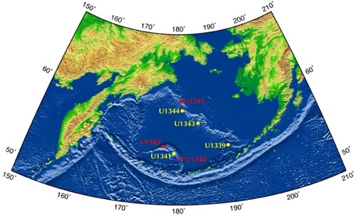
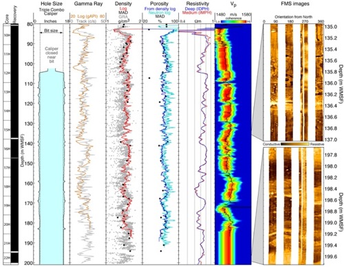
The primary objective of drilling at Site U1339 was to study high-resolution paleoceanography in the easternmost part of the Bering Sea. The average core recovery in the four holes drilled was 103%, ensuring a full record of the deposition history and a complete integration with the log data. The caliper log shows that hole size rarely exceeded the nominal bit size, indicating data of high quality (See Figure 3). Comparison with the gamma ray and density measurements made on the recovered core shows that logs and core measurements are in good aggreement, allowing for reliable core log integration. Some trends can be detected in the logs that express the changes in the sedimentation history at this site, such as the parallel decrease with depth in gamma ray, density and resistivity from 86 to 102 WMSF, which is typical of a retrograding fining upward sequence. Similar sequences, although less clearly defined, seem to define the general trend of the logs down the hole. The FMS images illustrate in particular the steep dip to the West of the deepest strata recovered in this site. Site U1341
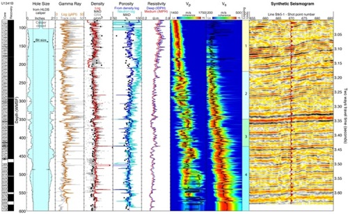
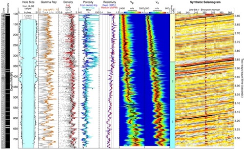
The primary objective of drilling at Site U1341 was to study high-resolution paleoceanography in the southern part of the Bering Sea, on the western flank of Bowers Ridge. The average core recovery in the three holes drilled was 102%, ensuring a full record of the deposition history and a complete integration with the log data. The caliper logs recorded by the density sonde and the FMS in Hole U1341B indicated that the borehole was irregular and significantly larger than the bit size, but that the tools maintained contact with the formation over most of the interval logged, ensuring the overall good quality of the data (See Figure 4). The combined analysis of the logs allows to define four logging units characterized by specific trends. Logging unit 1 (80-220 m WMSF) is characterized mainly by decreasing trends with depth in gamma ray and resistivity, interrupted by several highs indicative of authigenic carbonate. This unit coincides mostly with Lithologic Unit I, made of diatom ooze and diatom silt. Logging Unit 2 (220-350 mbsf) is defined by slightly increasing trends with depth in gamma ray and density, while resistivity mostly decreases. Several peaks in gamma ray can also be observed in this unit, generally due to higher uranium content and associated with authigenic carbonate observed in the core. The top of Logging Unit 3 (350-425 m WMSF) is defined by a sharp drop in density at ~350 m WSMF, and by similar changes in gamma ray and resistivity likely associated with the strong reflector that can be observed in Seismic Line Stk5-1 at 3340 ms two-way travel times. This reflector can be reproduced, although with a lesser amplitude, by a synthetic seismogram generated from the density and Vp logs. This Logging Unit is characterized by generally higher uranium values that can be associated with a higher higher Total Organic Carbon (TOC) measured on core samples from this interval. The top of Logging unit 4 (425-600 m WMSF) is defined by a drop in resistivity, followed by a decrease with depth over the entire unit. Gamma ray values are generally lower than in the overlying logging unit and display several peaks due to higher uranium content associated with subtle resistivity peaks and the occurence of authigenic carbonate and dolostones. Site U1343
Site U1343 was drilled on a topographic high near the Bering shelf to study high-resolution Pliocene-Pleistocene paleoceanography at a location proximal to the gateway to the Arctic Ocean. Its proximity to the current seasonal sea ice limit and the 2 km water depth were also likely to provide information regarding the history of mid-depth water in the Aleutian Basin. The average core recovery in the five holes drilled was 96.5%, ensuring a full record of the deposition history and a complete integration with the log data. The caliper log in Hole U1343E shows that the borehole was irregular and significantly larger than the bit size above ~430 m WMSF, but that the tools maintained contact with the formation over most of the interval logged, ensuring the overall good quality of the data (See Figure 5). The combined analysis of the different logs allows to identify three logging units. Due to the uniformity of the sediments at this site, these units are mostly defined by changes in trends and correlations rather than indications of significant changes in the formation. As the Vp log also allows correlations with the seismic stratigraphy, it was the primary guide in the delimitation of the units. Logging Unit 1 (100-330 m WMSF) is characterized mainly by a steady increase with depth in velocity, while the other log data remain mostly uniform despite some variability in the gamma ray. The velocity increase at the bottom of logging unit 1 is likely responsible for the strong reflector that can be observed at 2.86 s two-way travel times in Seismic Line Stk-1 crossing site U1343. While it was speculated that this reflector might indicate the existence of gas hydrate overlying free gas, the possible indications from the logs supporting the occurrence of gas hydrate were not conclusive. However, slightly higher velocity and resistivity trends and lower dipole waveform amplitudes above the reflector, as well a lower chlorinity values measured on several pore water samples, suggest that some amount of gas hydrate might be present. Logging Unit 2 (330-510 m WMSF) is defined by slightly decreasing trends with depth in resistivity, and by gamma ray values slightly higher than the shallower and deeper units. The top of Logging Unit 3 (510-745 m WMSF) is defined by a drop in gamma ray, an increase in Vp and a general change in the trends of all the logs. Below this depth, all logs display a variability with depth of wider amplitude and lower frequency than in the upper units, suggesting a significant change in the deposition history and rates. Site U1344
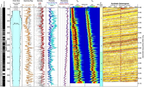
The objective of drilling at Site U1344 was to study high-resolution Pliocene-Pleistocene paleoceanography at a proximal gateway location to the Arctic Ocean at the deepest water depth of Expedition 323. The average core recovery in the five holes drilled was 92%, but only 87% in Hole U1344A, where significant gaps in recovery occurred between ~615 and 655 CSF. The caliper log in Hole U1344A indicated that the borehole was irregular and significantly larger than the bit size above ~300 m WMSF, but the generally good agreement between the gamma ray and density logs and the MAD and GRA core measurements suggest that the data are of good quality (See Figure 6). The combined analysis of the logs allows the identification of four logging units. Due to the uniformity of the sediments at this site, these units are also mostly defined by changes in trends and correlations rather than indications of significant changes in the formation. As the Vp log allows correlations with the seismic stratigraphy, it was the primary guide in the delineation of the units. Logging Unit 1 (100-330 m WMSF) is characterized mainly by a steady increase with depth in Vp and Vs, with some variability in the gamma ray suggesting some sandy intervals (e.g., 140-150 m WMSF). The bottom of this unit is defined by a noticeable drop in Vp, Vs, gamma ray, density and resistivity, immediately above a sharp peak in these measurements, particularly in Vs and resistivity, indicating a fine stiff layer that was apparently nor recovered. The low gamma ray suggests a more sandy layer, often prone to poor recovery. Using the preliminary Vp and density logs to generate a synthetic seismogram, we were able to match this interval with a strong reflector at 4.67 s two-way travel times (twtt) on Seismic line Stk 3-7 crossing Site U1344. Logging Unit 2 (330-460 m WMSF) is almost uniquely defined by the Vp and Vs log, both increasing steadily through the unit. A drop in Vp and Vs at 380 m WMSF can be correlated with a reflector at 4.73 s twtt which can be extended updip to high amplitudes that have been interpreted as free gas trapped at the bottom of the gas hydrate stability field. As in Site U1343, there were no conclusive indications from the logs to support the occurrence of gas hydrate. However, slightly higher velocity and resistivity trends and lower dipole waveform amplitudes above the reflector, as well as lower chlorinity values measured on several pore water samples, suggest that some amount of gas hydrate might be present. The top of Logging Unit 3 (460-620 m WMSF) is defined by an inflection in the velocity profiles which, combined with a decreasing trend in density, generates the reflector at 4.83 s twtt. The variability with depth in gamma ray and in most logs displays a cyclicity more clearly defined than in the upper units. Finally, the top of Logging Unit 4 (620-745 m WMSF) is defined by a sharp increase in Vp, Vs, gamma ray and density, as well as a significant change in the trends of all the logs. As in the deepest unit of Site U1343, mot logs display a variability with depth of wider amplitude and lower frequency than in the upper units, suggesting a significant change in the deposition history and rates. |
|||||||||||||||||||||||||||||||||||||||||||
|
Gilles Guerin: Logging Staff
Scientist, Borehole Research Group
Lamont-Doherty Earth Observatory of Columbia
University, PO Box 1000, 61 Route 9W, Palisades,
NY 10964, USA Tanzhuo Liu: Logging Staff Scientist,
Borehole Research Group, Lamont-Doherty Earth
Observatory of Columbia University, PO Box 1000,
61 Route 9W, Palisades, NY 10964, USA |
|||||||||||||||||||||||||||||||||||||||||||