Logging Summary
|
| IODP Expedition 335: |
|
Superfast Spreading Rate
Crust 4
Expedition 335
Scientific Party
|
| Introduction |
|
|
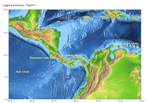
| Figure 1.
Location map of IODP Expedition
335. |
In the spring of 2011, IODP Expedition
335 returned to ODP/IODP Hole 1256D, in
the Eastern Equatorial Pacific Ocean
(see Figure 1),
for the first time since december 2005
(See IODP
Expedition 309/312 Proceedings).
The objectives were to deepen this
basement reference hole into the
gabbroic rocks of lower oceanic crust
and address fundamental questions on the
formation of the lower crust and on the
seismic layer 2/3 transition in a
superfast spreading environment. A more
complete overview of the expedition can
be found in the Expedition
335 Preliminary report.
Initially, a temperature log was planned
to record the formation equilibrium
temperature before drilling, and a
complete logging program was designed to
fully characterize the newly drilled
formation at the end of the expedition.
Because of hole trouble, technical
failures and time constraints, the triple
combo was the only logging tool string
deployed during the expedition. It
recorded the resistivity, density,
porosity and natural radioactivity of the
formation, as well as the hole size and
the temperature of the borehole fluid,
reaching the maximum depth of 1520 mbsf,
80 m below the deepest logs recorded at
the end of Expedition 312. Despite its
limited scope, the logging program
confirmed the beneficial results of the
various hole remediation operations during
the expedition, showing that Hole 1256D
was left in optimal conditions for future
deepening into the lower oceanic crust.
|
|
Logging
Operations
|
|
|
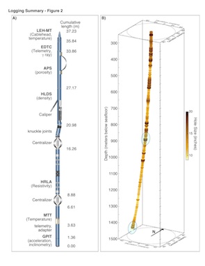
| Figure 2.
A) Logging tool string used during
Expedition 335. B) Hole trajectory
and size, derived from the
inclinometry data of the General
Purpose Inclinometry Tool (GPIT)
and the caliper log recorded
during Expedition 335. |
The triple combo tool string deployed
at the end of Expedition 335 is shown in
Figure 2A.
Several of the tools included were used
for the first time in IODP: the HRLA
(High Resolution Laterolog Array) was
used to measure resistivity beyond the
range of the Dual Laterolog that was
used in previous expeditions; the
Logging Equipment Head with Mud
Temperature (LEH-MT) was used to connect
the tool string to the wireline and
included a temperature sensor to measure
the borehole fluid temperature; the
Enhanced Digital Telemetry Cartridge
(EDTC-B) was used to transmit the data
recorded by the tool string, and
included a scintillation gamma ray
sensor to measure natural formation
radioactivity; finally, the Modular
Temperature Tool (MTT) had been used
only once before and never in the
temperature range encountered in Hole
1256D. All tools performed reliably and
provided high quality data over the
entire open hole.
The several weeks spent clearing and
stabilizing the interval between 920 and
970 mbsf and cleaning the deepest
section of the hole required more than
twenty lowerings of the drill string,
and multiple instances of reaming tight
intervals. After such operations, one of
the goals of the triple-combo run was to
record a caliper log over the entire
hole, to determine its condition, assess
the results of the cementing operations
and to help plan the final cementing to
stabilize Hole 1256D for future
expeditions. Figure
2B is a rendering of the hole size
and trajectory derived from the caliper
log and from the inclinometry data of
the General Purpose Inclinometry tool
(GPIT). It indicates that the hole
progressively deviates to the West and
contains several enlarged intervals, in
particular below 1400 mbsf where most of
the efforts were focused during the
final weeks of operations.
Logging Results
|
|
Figure 3. Summary of the
logs recorded during Expedition
335 in the deeper section of
Hole 1256D.
|
Figure 3
shows the main logs recorded in the
deepest section of Hole 1256D, some of
which was not reached by logging tools
during Expedition 312. The hole size in
the left track illustrates how irregular
the hole is below ~1410 mbsf. The
anomalously low density and high
porosity readings below this depth, as
indicated by the comparison with the
measurements on core samples, are a
direct consequence of the hole size and
and are not reliable. The decoupling
between the shallow and resistivity logs
is also a consequence of the hole size.
However the deepest resistivity
measurement were not affected by the
hole size.
One of the most significant
observations in the newly recorded data
is a decrease in resistivity with depth,
starting within Gabbro 1 (~1440 mbsf)
and more apparent by Gabbro 2 (below
~1480 mbsf). This contrast with the
expected resistivity increase in the
plutonic section suggests that the
deepest section might be fractured,
possibly part of a fault, which could
explain some of the difficulties
encountered while coring. However, these
resistivity values are in the same range
as shallower in the sheeted dikes
complex and could be representative of
the actual electric properties of the
dike screens and various levels of
alteration.
Hole Size
|
|
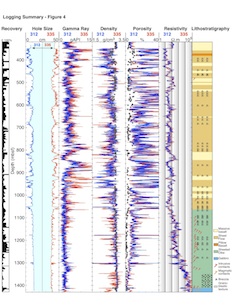
Figure 4. Comparison
between the main logs recorded by
the Triple Combo tool strings
during Expeditions 312 (blue
lines) and 335 (red lines).
|
|
|
Figure 5. Comparison
between the hole size during
Expeditions 312 and 335 around the
problematic zone 910-970 mbsf
|
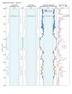
The comparison betwen the hole sizes
during Expeditions 312 and 335 in Figure 4 shows
that the hole has changed little after 5
years and despite working the hole for
several weeks before logging. Hole
enlargements are indicated in the same
intervals, and have similar extents.
This is confirmed by the very good
repeatibility between the different logs
displayed for both expeditions in Figure 4.
The only significant difference between
the two sets of logs is in the gamma ray
log between ~920 and ~960 mbsf,
suggesting that the cement used includes
radioactive nuclides detected by the
gamma ray sensor. This is shown more
clearly in Figure
5, where the differences between
the two holes are illustrated by showing
intervals of hole enlargement and hole
reduction between the two expeditions.
Intervals where hole size has
decreased, presumably because of the
cement emplaced when the bit was at ~960
mbsf, mostly coincide with higher gamma
ray reading during Expedition 335. The
largest difference in the gamma ray logs
is between 925 and 930 mbsf, where the
hole was the largest and presumably the
largest volume of cement was deposited.
The increase in hole size above 920 mbsf
is probably a consequence of the several
days spent trying to pass this depth.
The cement reduced the hole size and its
roughness between 930 mbsf and 970 mbsf,
eliminating asperities and allowing the
15 smooth reentries after the cementing
operations.
Temperature Logs
|
|
Figure 6. Temperature
log recorded during Expedition 335
and comparison with previous
temperature logs in Hole 1256D.
|
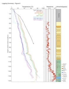
The comparison in Figure 6
between the temperature logs recorded by
the two temperature tools during
Expedition 335 and the temperatures
measured during previous expeditions in
Hole 1256D shows similar trends as the
borehole fluid recovers from the
disturbance of the drilling operations.
Several excursions to lower
temperatures, in particular around 925
mbsf and at 1060 mbsf, at the top of the
sheeted dike complex, coincide with
intervals with lower resistivity,
indicating more permeable intervals
where the formation might have been
invaded by the drilling fluid and is
consequently recovering more slowly from
the drilling process. The larger hole
diameter in these intervals also implies
larger borehole fluid volumes that could
also contribute to slower thermal
rebound. A kick at ~1300 mbsf, that was
also observed during Expedition 312,
coincides with lower resistivity and is
probably also associated with fluid
exchanges with the formation. These
anomalies will be the object of
numerical modeling, which in combination
with other logs should provide estimates
of the permeability in these intervals.
|
Gilles Guerin: Logging
Staff Scientist, Borehole Research
Group, Lamont-Doherty Earth Observatory
of Columbia University, PO Box 1000, 61
Route 9W, Palisades, NY 10964, USA
Natalia Zakharova:
Logging Staff Scientist, Borehole
Research Group, Lamont-Doherty Earth
Observatory of Columbia University, PO
Box 1000, 61 Route 9W, Palisades, NY
10964, USA
|
|
|