Logging Summary
|
| IODP Expedition 336: |
|
Mid-Atlantic Ridge
Microbiology
Expedition 336
Scientific Party
|
| Introduction |
|
|
|
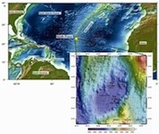
Figure 1.
Bathymetric map showing
Expedition 336 drill sites.
|
The North Pond region of the Atlantic
Ocean (22°45'N, 46°05'W) is in water
depths between 4414-4483 m (Figure 1).
It is an area that has been visited on
previous ocean drilling expeditions
(e.g. DSDP Leg 45, ODP Legs 109 and
174B) and is known as a site of
particularly vigorous circulation of
seawater in permeable 8 Ma basaltic
basement underlying a <300 m thick
sedimentary pile. IODP Expedition 336
aimed to examine the microbiology of
this sediment pond and the underlying
young, cold, and hydrologically active
flank of the Mid-Atlantic Ridge.
Drilling operations at three sites
included sediment/basalt coring,
basement logging, and installation of
two long-term subseafloor observatories
(at U1382A and U1383C).
The Expedition 336 drilling program was
designed to investigate (1) the origin
of deep-seated microbial communities,
and (2) the nature of microbial
communities in young ridge flanks and
their role in crustal weathering.
Downhole measurements were taken at
three sites: 395, U1382 and U1383.
|
|
Logging
Operations
|
The logging program on Expedition 336
was designed to obtain continuous in
situ physical properties data
needed to assist in defining structural
and lithological boundaries as a
function of depth. Additionally,
wireline logging data were compared to
results of laboratory analyses of
discrete samples to help delineate
alteration patterns, fracture densities,
and structural orientations and
determine how these correlate with fluid
flow. Downhole measurements compliment
those made on core by determining the
thickness and structure of lithologic
units in intervals where core recovery
is poor. These logs were also critical
for both shipboard hydrologic (packer)
tests as well as for the precise depth
placement of the CORK experiments.
Wireline tool strings were deployed in
all basement holes and provided
measurements including: temperature,
natural gamma ray, density, porosity,
resistivity, sonic velocity, and
microresistivity. Descriptions of the
wireline tools and their applications
are available here.
A series of three adapted triple
combination tool strings were deployed
(Microbiology Combo, Adapted
Microbiology Combo I and Adapted
Microbiology Combo II). These included
sondes to measure natural gamma
radiation, borehole diameter, density,
resistivity, temperature and density.
Additionally, on each of these tool
strings the basal sonde was the Deep
Exploration Biosphere Investigative tool
(DEBI-t). This tool was specifically
designed and built for Expedition 336 to
assess the natural fluorescence of
microbial communities exposed on the
borehole wall. Two other tool strings
incorporating the Formation MicroScanner
(FMS) were deployed in order to acquire
electrical images of the borehole wall
and two-axis borehole diameter
information (at Sites U1382 and U1383).
The sonic sonde was also deployed as
part of one of the FMS combinations (at
Site U1383).
Logging
Results
|
|
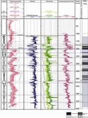
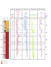
Figure 2.
Summary of Hole 395A logging
results.
|
|
|
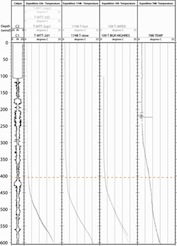
Figure
3. Summary figure of
borehole temperature, Hole 395A.
|
Hole 395
Following the successful removal of an
old CORK from Hole 395A (installed
during ODP Leg 174B), the hole was
logged with a Microbiology Combo
toolstring comprising the Hostile
Natural Gamma Ray Sonde (HNGS), the
General Purpose Inclinometry Tool
(GPIT), the Modular Temperature Tool
(MTT) (see Figure
2 and Figure
3) and the new in situ
deep UV fluorescence tool for detecting
microbial life in ocean floor boreholes
- DEBI-t. A rock ledge in the borehole
at around 180 m below seafloor (mbsf)
had to be bridged by lowering the
logging bit to ~198 mbsf, however
following this an open hole section of
405.7 m was logged (total depth reached
was 603.5 m). The logging results are
consistent with the data obtained by
Bartetzko et al. (2001) and allow the
distribution of massive basalt, pillow
basalts, altered lava flows, and rubble
zones (sedimentary breccia and
hyaloclastite) (Figure
2) to be distinguished.
Hole U1382
|
|
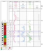
Figure 4.
Summary of Hole U1382A logging
results.
|
|
|
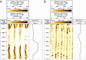
Figure
5. Composite of
features imaged by the
Formation MicroScanner (FMS),
Hole U1382A.
|
Hole U1382A was successfully logged
with two different tool strings (Adapted
Microbiology Combination I [EDTC, HLDS,
HRLA, DEBI-t], FMS-HNGS). An open hole
section of 105.61 m was measured over a
period of ~19.5 hours. Downhole log
measurements include natural total and
spectral gamma ray, temperature,
density, electrical resistivity,
electrical images and deep UV-induced
fluorescence (DEBI-t) (Figure 4).
The borehole remained in good condition
throughout logging and no obvious tight
spots were encountered in open hole.
Preliminary interpretation of the
downhole data divided Hole U1382A into
eleven log units (using gamma ray,
resistivity and density). Integration of
core and log measurements and
observations showed excellent
correspondence between potassium
concentrations provided by shipboard
NGR, spectral gamma ray logging tool and
whole rock geochemical analyses. FMS
data (Figure 5)
were combined with images of the
external surfaces of whole round cores.
Prominent veins with alteration halos in
core of the massive flows can be matched
up with fractures in the FMS images.
Also, logging results constrain the
depth of the peridotite interval from
165 to 167 wmsf (based on density and
low K/U ratios).
|
|
Figure 6.
Summary of Hole U1383C logging
results.
|
|
|
Figure
7. Composite of
features imaged by the Formation
MicroScanner (FMS), Hole U1383C.
|
Hole U1383
Wireline logging data collected in Hole
U1383C include natural total and
spectral gamma ray, density,
compressional velocity, electrical
images and deep UV-induced fluorescence
(DEBI-t) of an open hole section of
274.5 m (Figure
6). Three main Lithologic Units
were identified. Lithologic Unit I is
characterized by variable caliper,
density and sonic velocity values. Gamma
ray intensities are generally low, but
increase in the bottom part of the unit.
Lithologic Unit II has a uniform
caliper, high densities and apparent
sonic velocities and shows
high-resistivity massive flows with
fractures in the FMS images (for
examples of FMS imagery see Figure 7).
Lithologic Unit III has an upper section
(153-166 wmsf) which is characterized by
a drop in density, apparent resistivity
and velocity and an increase in gamma
ray intensity. This interval corresponds
to thin flows with inter-pillow/flow
sediments and tectonic breccias. From
166 wmsf to the bottom of the hole, the
logging data reveal fairly uniform
values for density and apparent velocity
and resistivity. Areas with peaks in
gamma ray intensity correspond to
intervals with abundant hyaloclastite in
the recovered core (in particular around
175 wmsf, and from 220 to 250 wmsf).
References
Bartetzko, A., Pezard, P., Goldberg,
D., Sun, Y.-F., Becker, K., 2001.
Volcanic stratigraphy of DSDP/ODP Hole
395A: An interpretation using
well-logging data. Mar. Geophys. Res.
22, 111-127.
|
Louise Anderson:
Logging Staff Scientist, Borehole
Research Group University of Leicester,
University Road, Leicester, LE1 7RH.
|
|
|