Logging Summary
|
| IODP Expedition 340: |
|
Lesser Antilles Volcanism
and Landslides
Expedition 340
Scientific Party
|
| Introduction |
|
|
|
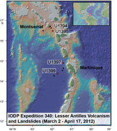
Figure 1.
Location of the sites drilled
during IODP Expedition 340.
|
IODP Expedition 340 drilled nine sites
along the Lesser Antilles arc (see Figure 1) to
explore the constructive and destructive
processes related to island arc
volcanism. The Lesser Antilles arc
offers a diverse range of magmatic,
eruptive, and destructive styles across
a relatively small geographic area. The
dataset collected during Expedition 340
includes nearshore submarine cores that
penetrate 100s of meters into volcanic
island landslides, providing a long-term
record of volcanic eruption cycles and
magmatic evolution. Previously such
records have been limited to the results
of subaerial geologic studies, remote
sensing and shallow piston cores. The
combination of land-based knowledge with
information from related seafloor
deposits will provide a more complete
picture of volcanic activity in this
geologic setting. Data acquired during
this expedition may also provide a
better understanding of the mechanisms
involved in both transport and
deposition of volcanic debris avalanche
deposits, and be used to better assess
the potential for future volcanic
hazards associated with future
avalanches. A more complete overview of
the expedition operations and
preliminary scientific results are
available in the Expedition
340 Preliminary Report.
|
|
Logging Tools
and Operations
|
|
|
|
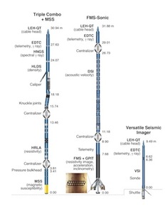
Figure
2. Logging tool
strings planned for IODP
Expedition 340.
|
Four of the nine drilled sites were
logged with the standard suite of
wireline logging tools, in order to
complement the coring program by
measuring in situ physical
properties of the previously unsampled
debris avalanche deposits and to
characterize the formation through
intervals of incomplete core recovery.
Two logged sites (U1394 and U1395) are
located near Montserrat in the northern
part of the arc, and two logged sites
(U1397 and U1399) are located in the
vicinity of Martinique in the southern
part of the arc (see Figure 1).
At Sites U1394 and U1399, the logged
intervals cover a region with nearly
full core recovery and provide a
complementary data set. Conversely, at
Sites U1395 and U1397, the logged
intervals correspond to regions of very
poor core recovery and thus provide
characterization of lithologies that
were not recovered in cores.
The logging tool strings deployed
during Expedition 340 are shown in Figure 2:
the triple combo; the FMS-Sonic tool
string; and the VSI tool string for
vertical seismic profiles (VSPs).
Although initially planned for
deployment at only a few sites, magnetic
susceptibility logs from the Magnetic
Susceptibility Sonde (MSS) were found to
be valuable for the entire region so the
MSS was included in every run of the
triple combo tool string. In addition to
running the triple combo and FMS-sonic
tool strings, VSPs were planned for
three sites to refine the velocity model
used for interpretation of regional
seismic surveys as well as to facilitate
integration of the logs and coring data
with seismic data. Ultimately,
challenging drilling and borehole
conditions and forced abandonment of
multiple holes limited the number of
sites that were logged and the tools and
tool strings that were run during the
expedition.
|
|
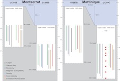
Figure 3. Logged
intervals and tool strings run in
each hole during IODP Expedition
340.
|
Due to unstable borehole conditions,
Holes U1394B, U1395B, and U1399C were
displaced with heavy logging mud (~10.5
ppg) prior to logging. Hole U1397B was
displaced with seawater rather than
heavy mud; the unstable hole conditions
made it necessary to circulate while
pulling pipe up to logging depth, which
would have flushed out any special
displacement fluid. All logging
operations took place under favorable
sea conditions, with low heave (< 1.0
m, peak-to-peak).
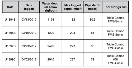
Logging operations are summarized in
the following table and Figure 3.
Data
and Results
Overview
We present here a summary of the
logging data and some highlights from
each site. The drill pipe was raised to
~80 meters below seafloor prior to
logging because of hole instability in
shallow sediments, so logs are recorded
only below this depth. Logging data are
initially referenced to depth below the
rig floor; after logging is completed,
all data are shifted to a seafloor
reference and depth-matched to remove
offsets between different logging runs.
The resulting depth scale, used for all
data presented here, is meters below
seafloor (mbsf).
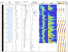
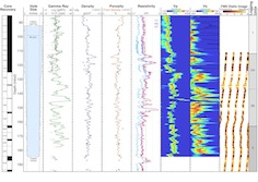
Montserrat - Site U1394
|
|
Figure 4. Summary of
logging data recorded in Hole
U1394B.
|
Site U1394 was drilled as a site
proximal to the island of Montserrat, at
1114 m water depth (coring), to study
multiple units of debris avalanche
Deposit 2 and associated erosional
processes. The primary objective of
drilling this deposit was to provide
information to help determine whether
mass-wasting processes occurred as a
single event or as a series of
closely-spaced, separate events. Two
holes were drilled and average core
recovery in the most complete hole
(U1394B) was 78%. Average recovery was
>100% in the logged interval in Hole
U1394B, allowing full integration with
the log data. The caliper log in Hole
U1394B shows that hole size rarely
exceeded the bit size, indicating
generally high quality data (see Figure 4).
There is a short interval (99-106 mbsf)
where the FMS pads were closed due to
excessive sticking over which no FMS
images were recorded. Additionally, due
to concerns about borehole stability,
the HLDS was run without a source so no
density data were recorded.
Comparison of logs with gamma ray and
magnetic susceptibility measurements
made on the recovered core shows that
logs and core measurements are in good
agreement, allowing for reliable
core-log integration. There are not
enough large-scale differences in this
~100-m interval of open hole to warrant
subdivision into distinct units, but
some trends are detected in the logs.
Coinciding peaks in resistivity,
magnetic susceptibility, and often Vp,
may be associated with similarly-scaled
turbidite units identified in the core.
The logs likely reflect changing grain
size and/or variations in dominant
lithology within these units. FMS images
also show some strong resistivity
contrasts that correspond to changing
grain size/lithology in the cores.
A VSP experiment was attempted in Hole
U1394B, but the tool string could not be
passed below the drill bit and the run
was abandoned after significant efforts.
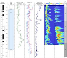
Montserrat - Site U1395
|
|
| Figure 5. Summary of
logging data recorded in Hole
U1395B. |
The primary objective of drilling Site
U1395 was to characterize the distal
turbidite deposits associated with
Montserrat landslides. Turbidites in
this location should provide records of
recent pyroclastic flow events, and dome
and flank collapses, as well as help
constrain the long-term background
sedimentation rate in the northern part
of the Lesser Antilles arc. The average
core recovery in the two holes drilled
was 65%, with significant gaps in
recovery below ~120 mbsf. The caliper
log in Hole U1395B shows that borehole
diameter ranges from 17 inches just
below the pipe to 11 inches at the base
of the hole, indicating that the tools
maintained good contact with borehole
wall over most of the logged interval,
ensuring generally good quality data.
The FMS calipers were closed for several
meters between 100 mbsf and 110 mbsf due
to high cable tension during pipe
reentry, but the images recorded below
110 mbsf are of high quality. Vp logs
show high coherence, indicating good
quality, but Vs logs will require some
postcruise processing (particularly
between 85 and 125 mbsf) to improve
their quality. The MSS malfunctioned
during this logging run, so no magnetic
susceptibility data were recorded in
this hole.
Combined analysis of the logs allows
for the identification of three logging
units in Hole U1395B, based on
characteristic features and trends (See
Figure 5).
Logging Unit 1 (85-112 mbsf) is
characterized by consistent,
low-variability profiles in density,
resistivity, and Vp. Density appears to
have a step increase at 92 mbsf, but
this is likely a response to the closing
of the HLDS caliper at the end of the
logging run. This unit coincides with
Lithologic Unit G, which is dominated by
hemipelagic sediment.
The top of Logging Unit 2 (112-163
mbsf) is defined by abrupt changes in
gamma ray, density, and resistivity.
Gamma ray, density, and Vp all display
high-amplitude variability throughout
this unit, relative to Unit 1. Logging
Unit 2 is further subdivided into two
subunits: Subunit 2A (112-137 mbsf) and
Subunit 2B (137-163 mbsf). Several
intervals of decreased gamma ray and
increased density, resistivity, and Vp
in Subunit 2A likely correspond to
pumiceous turbidites, which are
separated by intervals of hemipelagic
sediment. Logging Subunit 2B is
characterized by a series of gamma ray
highs that, in some cases coincide with
high density, resistivity, and Vp, but
in others, coincide with decreased
density and resistivity. It is difficult
to interpret these features in terms of
lithology due to the poor core recovery
through this interval, but they may
reflect different types of turbidites
(e.g. pumiceous vs. low-pumice).
Logging Unit 3 (163-204 mbsf) is
characterized by a return to lower
frequency variations in most of the
downhole measurements, similar to what
is observed in Logging Unit 1. This may
indicate a return to greater abundance
of hemipelagic sediment. However,
distinct variability in gamma ray and
velocity, and some sharp boundaries
between layers in FMS images, suggest
that there may be lithological changes
throughout this unit. A highly resistive
layer centered on ~188 mbsf coincides
with the recovery of a partial core
containing lithified material at roughly
the same depth, supporting the idea of
lithological heterogeneity at depth in
the hole.
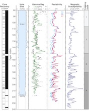
Martinique - Site U1397
|
|
Figure 6.
Summary of logging data recorded
in Hole U1397B.
|
Site U1397 is located on a local
topographic high, bounded by canyons, to
the northwest of Martinique. The
objectives for drilling this site were
to provide a marine record of the
eruptive history of Dominica and
Martinique's major volcanoes by studying
tephra deposits, and to characterize a
distinctive interval in the seismic
survey data identified by chaotic
reflections. The average core recovery
in the two holes drilled was 54%, with
the most significant gaps occurring
below ~120 mbsf. The caliper log in Hole
U1397B indicated that the borehole was
significantly larger than bit size, and
both HLDS and FMS calipers were opened
to their full extent through most of the
open hole, indicating that data quality
is likely compromised. Due to uncertain
hole conditions, the HLDS was run
without a source so no density data were
recorded. Despite the enlarged borehole,
comparison between gamma ray logs and
natural gamma ray (NGR) measurements
made on recovered core shows good
agreement, indicating that core-log
integration is possible. There are also
some intervals of high coherence in the
velocity logs, particularly Vp,
indicating that compressional waves were
adequately recorded over a significant
portion of the logged interval.
Based on characteristic features and
trends in the logs, four logging units
were identified (see Figure 6).
Logging Unit 1 (85-90 mbsf) is
characterized by relatively consistent
resistivity and gamma ray values, and a
decreasing trend in magnetic
susceptibility with depth. In contrast,
Logging Unit 2 (90-127 mbsf) is
distinguished by four intervals on the
scale of 5-10 m that each exhibit
increasing resistivity and Vp downhole
with sharp boundaries between intervals.
These boundaries correspond to distinct
changes in the magnetic susceptibility
log, with a general trend of local
increases in magnetic susceptibility and
elevated resistivity and Vp at the base
of each interval. These features likely
correspond with a series of
volcaniclastic turbidites recovered in
cores.
Logging Unit 3 (127-185 mbsf) is
identified by a return to lower
variability in resistivity and Vp logs.
This unit is further subdivided based on
subtle differences in magnetic
susceptibility log character into
Subunit 3A (127-155 mbsf) and Subunit 3B
(155-185 mbsf). There is
higher-amplitude variability in magnetic
susceptibility in Subunit 3A than in 3B.
However, there are higher-amplitude
changes in resistivity and Vp in Subunit
3B. Based on limited core recovery, the
Logging Unit 2/3 boundary may reflect a
lithological change from volcaniclastic
turbidites above to mud-rich sandstones
and consolidated mudstones below.
Logging Unit 4 (185-223 mbsf) is
characterized by increased resistivity,
magnetic susceptibility, and Vp,
relative to the overlying unit. There is
a ~5 m thick interval with high
resistivity and Vp at the top of Logging
Unit 4, but below this interval,
resistivity curves become increasingly
separated, indicating that logs in this
unit may be affected by degraded hole
conditions at the base of the hole.
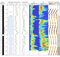
Martinique - Site U1399
|
|
| Figure 7.
Summary of logging data
recorded with the Triple Combo in
Hole U1399C. |
|
|
| Figure
8. Summary of logging
data recorded with the FMS-sonic
tool string in Hole U1399C. |
The primary objective of drilling Site
U1399, located west of Martinique, was
to characterize the processes of debris
avalanche emplacement and the associated
erosion. The site is located on one of
the oldest chaotic deposits imaged in
seismic survey data, and coring was
planned to penetrate volcanic and
biogenic sediment as well as the chaotic
debris avalanche deposits. The average
core recovery in the two cored holes at
this site was 94%, providing a nearly
complete record of the targeted deposits
to compare with the logs recorded in
logging-dedicated Hole U1399C (drilled
when coring in Hole U1399B became too
unstable to continue operations). The
HLDS caliper log shows that Hole U1399C
was relatively in gauge, with the
exception of three zones where borehole
size was significantly larger than bit
size (see Figure
7). This indicates that the tools
maintained good contact with the
borehole wall for most of the logged
interval, ensuring good quality data
from the tools in the triple combo. FMS
caliper data from subsequent passes
suggest that hole conditions
deteriorated significantly between the
VSP (run #2) and the FMS-sonic runs (run
#3), with multiple narrowed zones,
allowing the FMS-sonic tool string to
reach a total depth ~26 m shallower than
the earliest triple combo run (see Figure 8).
Despite deteriorating hole conditions,
the repeatability of measurements is
good between multiple passes for both
tool strings, and the gamma ray
measurements from both tool strings show
good agreement. No radioactive sources
were used in this hole as a consequence
of unstable conditions.
Combined analysis of the different logs
allows for the identification of four
logging units, primarily on the basis of
responses from the triple combo data
(gamma ray, resistivity, and magnetic
susceptibility). Logging Unit 1 (80-106
mbsf) is characterized mainly by an
increase with depth in gamma ray.
Magnetic susceptibility and resistivity
are similar to one another in character,
and show small net decreases with depth.
The transition from Logging Unit 1 to
Logging Unit 2 (106-150 mbsf) is marked
by a sharp decrease in gamma ray, with
sharp increases in resistivity and
magnetic susceptibility. All log
responses are affected by the three
washed out zones in Logging Unit 2.
Between 140 and 150 mbsf (at the base of
this unit) there is an interval of
increased gamma ray values, repeated in
all logging runs. This unit may
correspond to an interval of highly
deformed and contorted sediment
recognized in cores from Hole U1399A.
Logging Unit 3 (150-181 mbsf) is
characterized by higher amplitude
variability in gamma ray, resistivity,
and magnetic susceptibility. Similar to
the Logging Unit 1/2 boundary, the
transition from Logging Unit 2 to
Logging Unit 3 is marked by a step
decrease in gamma ray and increases in
resistivity and magnetic susceptibility.
Generally lower gamma ray values
coincide with high resistivity and high
magnetic susceptibility features in this
unit, which may reflect the presence of
a thick sequence of pumice-rich
turbidites interbedded with mud.
Higher amplitude and more regular
variability in resistivity and magnetic
susceptibility characterize Logging Unit
4 (181-237 mbsf). This unit exhibits the
most variable magnetic susceptibility
profile in Hole U1399C, including some
significant peaks that often correspond
to similarly elevated values of
resistivity. One such feature (~205-208
mbsf) coincides with the depth in Hole
U1399A at which the coring system was
changed from APC to XCB, indicating a
significant change in lithology and/or
induration at this depth.
|
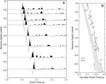
|
Figure 9.
VSP data recorded in Hole U1399C.
|
A VSP experiment was conducted in Hole
U1399C in order to help constrain the
seismic stratigraphy of mass transport
deposits. Eight stations between 99 mbsf
and the bottom of the hole (237 mbsf)
yielded reliable check shot travel times
(see Figure 9).
A comparison of data from both the VSP
and the sonic tool with predictions of
velocity from the seismic data at this
site (1800-2200 m/s) indicates that
measured velocity is slower than
predicted.
|
Angela Slagle: Logging
Staff Scientist, Borehole Research
Group, Lamont-Doherty Earth Observatory
of Columbia University, PO Box 1000, 61
Route 9W, Palisades, NY 10964 USA.
Sally Morgan: Logging
Staff Scientist, Borehole Research
Group, Department of Geology, University
of Leicester, University Road,
Leicester, LE1 7RH.
|
|
|