|
|
|
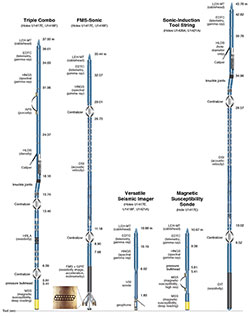
Figure
2. Logging tool
strings used during Expedition
341.
|
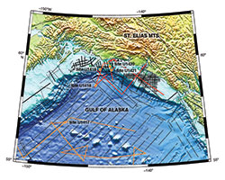
Downhole logging operations were
carried out at four of the five drilled
sites. Logged Sites U1420 and U1421 are
located on the continental shelf and
slope, respectively, while Sites U1417
and U1418 are further offshore in the
Surveyor Fan. At Sites U1417 and U1418,
average core recovery was relatively
good (70-86%) so logging data provide a
complementary data set. At Sites U1420
and U1421, however, core recovery was
poor (14-24%) and thus logging data
provide the primary means of sediment
characterization. Slope Site U1419 was
not logged due to its shallow depth of
penetration (<200 m below seafloor).
The logging program for Expedition 341
was designed to measure in situ
geophysical and lithological properties
of thick deposits of glacial sediments,
as well as the underlying pre-glacial
and overlying post-glacial sediments.
Five different tool strings were
deployed during Expedition 341 (Figure 2).
Two standard IODP wireline tool strings
were run at Sites U1417 and U1418: the
triple combo (measuring gamma radiation,
density, resistivity, deep reading
magnetic susceptibility, and borehole
diameter) and the FMS-Sonic tool string
(measuring gamma radiation and sonic
velocity and recording resistivity
images). Due to concerns about hole
stability based on poor core recovery
and challenging coring conditions in the
shelf and slope environments, a
Sonic-Induction tool string was the
primary logging string deployed at Sites
U1420 and U1421. This string was
designed to provide the highest priority
measurements in a single logging run,
including gamma radiation, sonic
velocity, resistivity, and borehole
diameter. The VSI tool string (measuring
acoustic travel-time) was run at Sites
U1417, U1418, and U1421 to collect
vertical seismic profiles but adequate
travel-times were recorded only at Sites
U1417 and U1421. One technical highlight
of the expedition was the first at-sea
deployment of the full Magnetic
Susceptibility Sonde (MSS) tool string
(comprising both deep reading and
high-resolution magnetic susceptibility
sensors), carried out as an additional
run at Site U1417.
Hole preparation prior to logging
varied based on formation conditions. In
Holes U1417E and U1418F where drilling
progressed relatively smoothly, seawater
was used as the logging fluid. Due to
more difficult drilling conditions in
Holes U1420A and U1421A, these holes
were stabilized with heavy logging mud
prior to logging (mud weight: 10.5 ppg
for U1420A, 11.8 ppg for U1421A). All
logging operations took place in
favorable sea conditions.
Logging operations are summarized in
the following table:
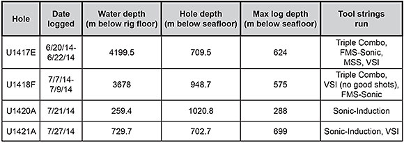
Site U1417
|
|
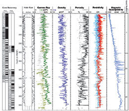
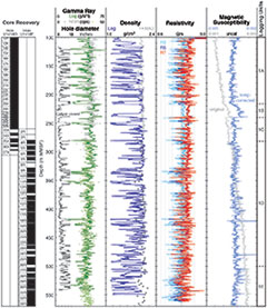
Figure 3. Summary of
logging data recorded with the
Triple Combo in Hole U1417E.
|
Site U1417 is situated in the distal
deep sea Surveyor Fan at ~4190 m water
depth, ~60 km from the Surveyor Channel
that delivers sediment to the site via
overbank deposits. The site was chosen
to provide a long record of Neogene
glacial and tectonic processes,
including the onset of tidewater
glaciation, the formation of the
Surveyor Channel and Fan, early uplift
of the St. Elias orogen, and preglacial
to glacial conditions. Five holes were
drilled, penetrating 709.5 m below
seafloor, with ages extending from
Miocene to Holocene. Core recovery
ranged from 42% to 99%, with lowest
recovery rates deeper than ~230 mbsf.
Four principle lithologies were drilled:
clastic wedge sedimentation, bioturbated
mud, interbedded biogenic and glacigenic
sediment, and glacigenic sediment.
Downhole logs were recorded in Hole
U1417E with four different tool strings
(Triple Combo, FMS-Sonic, VSI, and MSS).
The caliper log showed an irregular
borehole with diameter ranging from
<5 inches to >18 inches,
significantly larger than the bit size
shallower than 305 m WMSF. Deeper than
305 m WMSF, there is reasonable
agreement between the gamma ray and
density logs and the core gamma ray
attenuation (GRA) and
moisture-and-density (MAD) data,
suggesting that these data are good
quality (see Figure
3). A series of bridges were
encountered during logging; the Triple
Combo reached an impassable obstruction
at ~80 m above total depth and each
successive tool string was blocked at a
shallower depth.
|
|
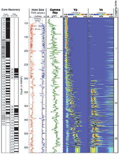
| Figure 4. Summary of
logging data recorded with the
FMS-Sonic tool string in Hole
U1417E. |
Based on hole condition and
characteristic trends and features in
the data, two distinct logging units
were identified for Hole U1417E (Figure 3, Figure 4).
Logging Unit 1 is defined primarily by
highly variable borehole diameter.
Within this unit, gamma ray, magnetic
susceptibility, and compressional wave
velocity (Vp) logs are the most robust
to borehole conditions. Logging Unit 2
is characterized by improved borehole
conditions and the quality of the
logging data is higher throughout this
unit. Unit 2 was subdivided into two
sub-units. Sub-Unit 2A shows elevated
gamma ray, density, and velocity values
relative to the unit above. Magnetic
susceptibility shows higher amplitude
variability and co-varies with gamma
ray. Sub-Unit 2B is distinguished by an
initial, rapid decrease in density,
resistivity, and velocity with depth,
followed by general increases. Magnetic
susceptibility displays less dynamic
range in this sub-unit. Together, these
data indicate that downhole logs are
likely responding to variations in
lithology.
The VSI tool string was run in Hole
U1417E to conduct a vertical seismic
profile (VSP) experiment. The VSI
caliper arm had difficulty achieving
good clamping force due to the rugose
borehole wall and soft sediments at the
shallow sub-seafloor depth reached by
the tool string (max depth 218 m WMSF).
Despite these limitations, adequate
travel times were recorded with two
shots at one depth station during the
VSP.
Results from the full MSS tool string
run in Hole U1417E are described below
(see “Magnetic susceptibility
measurements”).
Site U1418
|
|
Figure 5.
Summary of logging data recorded
with the Triple Combo in Hole
U1418F.
|
Site U1418 is located on a slightly
elevated portion of the proximal
Surveyor Fan at ~3670 m water depth,
between a modern channel that feeds the
Aleutian Trench to the west and the
relict Bering Channel to the east. The
site was chosen to develop a high
temporal resolution proximal record of
glacial-interglacial dynamics, fan
development, and paleoceanography. Six
holes were drilled, reaching as deep as
948.7 mbsf, with ages extending back to
early Pleistocene. Core recovery ranged
from 72% to 100%. Three primary
lithologies were drilled: a mass
transport deposit, glacigenic sediment,
and interbedded biogenic and glacigenic
sediment.
Downhole logs were recorded with two
tool strings (Triple Combo, FMS-Sonic);
the VSI tool string was also run but no
good shots were recorded. Borehole
conditions were variable, with numerous
washed-out intervals where hole diameter
exceeded the 18-inch limit of the
caliper arm. The tool strings deployed
encountered blockages at different
depths between the first logging run
(Triple Combo) and the last logging run
(FMS-Sonic), indicating that hole
conditions were deteriorating over the
course of logging operations.
|
|
| Figure 6.
Summary of logging data recorded
with the FMS-Sonic tool string in
Hole U1418F. |
The logged interval was assigned to a
single logging unit because the
character of the logs changes gradually
downhole with no major steps in the base
levels (Figure
5, Figure
6). At the scale of this unit,
total gamma ray values range from ~35 to
55 gAPI units, with the exception of
anomalously low values corresponding to
washed-out intervals. The natural
radiation signal is generally dominated
by potassium and thorium content, with
uranium contributing in minor way. For
the most part, the three radioactive
elements co-vary, suggesting that they
are mainly responding to clay mineralogy
or content. Density measurements do not
show specific characteristics in the
logged interval. Resistivity data show a
slight decrease with depth over the
logged interval, which is counter to the
expected increasing trend with depth due
to compaction; however, lower mean
values below 462 m WMSF may simply be a
response to the wider borehole diameter
in this interval. Magnetic
susceptibility values vary around a
relatively consistent mean value
downhole, and velocity measurements show
a generally increasing trend with depth.
Site U1420
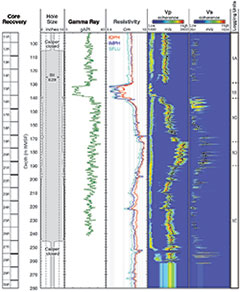 |
Figure 7.
Summary of logging data recorded
in Hole U1420A.
|
Site U1420 is situated at ~250 m water
depth within the Bering Trough, a
shelf-crossing trough thought to have
formed by the Bering Glacier advancing
across the shelf during glacial maxima.
The goal of drilling Site U1420 was to
test the hypothesis that the onset of
ice streams resulted in correspondingly
high rates of erosion that could affect
orogenic processes and behavior, and to
establish age control for the glacial
advance. One hole was drilled at Site
U1420, penetrating to 1020.8 mbsf. Due
to limited core recovery (<14%),
glacigenic sediment was the only primary
lithology identified at this site and
the age of drilled sediments was
determined to be middle Pleistocene to
Holocene.
Because of concerns about borehole
stability based on poor core recovery
and challenging coring conditions, a
sonic-induction tool string (see
“Logging tools and operations” above for
description) was the only tool string
deployed in Hole U1420A. Due to an
obstruction or collapse of the borehole,
the tool string was only able to record
data between ~90 and 290 m WMSF. The
caliper log indicates that borehole
diameter exceeded 18 inches in the upper
and lower sections of the logged
interval. Borehole size was smaller (~15
inches) between ~140 and 200 m WMSF.
Even in this large diameter hole, the
data seem to be of good quality, as the
measurements show relatively consistent
variability through multiple passes of
the logged interval.
The logged interval in Hole U1420A was
assigned to a single logging unit based on
the minimal measurements recorded and the
limited depth interval of the logging data
in the context of the entire drilled
depth. However, on the basis of
distinctive changes in resistivity and
velocity measurements, logging Unit 1 was
divided into five subunits (Figure 7).
Logging Subunit 1A is characterized by a
relatively constant mean trend in all data
types, with little net downhole variation.
Subunit 1B is distinguished by abrupt
decreases in gamma ray and resistivity
measurements. The deep resistivity curve
likely measured formation, whereas the
shallow and medium curves most likely
reflect the resistivity of the borehole
fluid, given the large borehole diameter.
Gamma radiation, resistivity, and
compressional velocity (Vp) all increase
at the Subunit 1B/1C boundary, whereas
gamma radiation decreases and resistivity
and Vp increase across the Subunit 1C/1D
boundary. All three of these logs then
decrease and the caliper increases in
Subunit 1E. Overall, resistivity in Hole
U1420A is generally >3.0 ohm-m, with
the deepest resistivity curve showing
values >8 ohm-m in Subunit 1D. The
relatively high Vp values (~1700 to
>2500 m/s) measured within this shallow
logged interval support the idea that high
measured resistivity at Site U1420 may be
due to a combination of reduced pore water
salinity (observed in porewater
geochemistry) and lithology (possibly a
clast-rich diamict, consistent with
glacigenic origin).
Site U1421
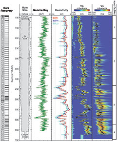 |
Figure 8.
Summary of logging data recorded
in Hole U1421A.
|
Site U1421 is located seaward of the
glacial Bering Trough mouth at ~720 m
water depth. The key drilling objective
was to establish age control for a
series of seismic sequences that
correlate to shelf sequences drilled at
Site U1420. Three holes were drilled at
Site U1421, penetrating to a maximum
depth of 702.7 mbsf. Average core
recovery ranged from 20% to 100% but in
the logged interval, between ~96 m WMSF
and total depth, the average recovery
was only 10%. Two primary lithologies
were identified based on Site U1421
cores - glacigenic sediment and
interbedded biogenic and glacigenic
sediment - and sediments were determined
to be between middle Pleistocene and
Holocene age.
Two tool strings were deployed in Hole
U1421A on the basis of potentially
unstable borehole conditions and limited
time at the end of the expedition: the
sonic-induction tool string (see
“Logging tools and operations” above)
and the VSI tool string. With the
exception of some thin washouts,
borehole diameter varied smoothly and
rarely exceeded 18 inches. The character
of the borehole wall in Hole U1421A on
the shelf (Figure
8) is a distinct change from the
rugose character observed at the deeper
water sites (U1417 and U1418; Figure 3, Figure 5).
There is a distinct separation between
the shallow resistivity curve and the
medium and deep resistivity curves
through much of the logged interval in
Hole U1421A. Given that the borehole
diameter is within the depth of
investigation of all three curves, this
could indicate that the shallow borehole
wall was invaded by logging mud, which
has relatively low resistivity.
Gamma ray was measured through the
entire hole, through the drill pipe from
the seawater-seafloor boundary to the
base of the pipe, and in open hole down
to total depth. The gamma ray signal is
highly attenuated when the tool was
inside the bottom-hole assembly (above
~96 m WMSF); however, there is still a
reasonable agreement between gamma ray
from downhole logs and core logs, and
similar trends are shown in both data
sets.
The logged interval in Hole U1421A was
divided into four units based on
distinct changes in character and trends
in gamma ray, resistivity, and
compressional wave velocity (Vp) logs (Figure 8).
Logging Unit 1 is characterized by
relatively high gamma ray values, with a
slight decreasing trend with depth,
while resistivity and Vp have no trend
with depth. Logging Unit 2 is
distinguished by a general decrease in
gamma ray values and a bimodal pattern
in resistivity and Vp, defined by
intervals of high, relatively constant
values separated by intervals of very
low values. The Unit 2/3 boundary is
marked by a dramatic decrease in
resistivity and Vp. The greatest
fluctuations in all logged parameters is
observed in Unit 3 and variations may be
correlated with changes in borehole
diameter, which may in turn be related
to lithology variations. Logging Unit 4
is characterized by relatively high
values and distinctly lower variability
in all log data.
The VSP in Hole U1421A provides data for
establishing a link between core and log
data (recorded in depth) and seismic
surveys (recorded in two-way traveltime)
at the location of the borehole. Six
stations yielded traveltimes ranging from
1.278 s TWTT below sea level at 284.7 m
WMSF to 1.641 s TWTT at the deepest
station at 687 m WMSF. A linear trend is
observed in the VSP traveltime data
consistent with the increasing trend with
depth in the velocity log (Figure 8).
Magnetic susceptibility
measurements
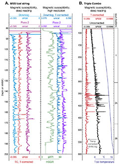 |
Figure 9.
Summary of magnetic susceptibility
logs recorded in Hole U1417E.
|
Expedition 341 marks the first at-sea
deployment of the full Magnetic
Susceptibility Sonde (officially,
MSS-B), built by Lamont-Doherty Earth
Observatory between 2010 and 2012 to
replace an earlier version of the tool.
Comprising both a deep-reading sensor,
which was also included in all Triple
Combo runs, and a high-resolution
sensor, the full MSS tool has the
capability to make magnetic
susceptibility measurements at 10 and 40
cm vertical resolution.
The MSS tool string was run in Hole U1417E
in a limited depth interval due to a
borehole obstruction deeper ~200 m WMSF.
Comparison of deep-reading sensor data
between the Triple Combo and MSS runs, as
well as high-resolution data from multiple
passes of the MSS tool string, show that
magnetic susceptibility measurements were
repeatable (Figure
9A). The high-resolution data seem
to track gamma ray variations, both of
which are likely responding to fine-scale
lithology changes. There is also a trend
superimposed on all magnetic
susceptibility logs that is likely related
to internal tool temperature. When the
temperature of the MSS increases linearly
with depth, for example as observed in the
deep-reading MSS data from the Triple
Combo, a simple linear correction can be
applied (Figure
9B). Non-linear tool temperature
effects, such as those observed during the
short passes of the MSS tool string,
cannot be corrected so simply and
post-cruise investigation will be required
to better understand tool temperature
responses.
Core-log seismic integration
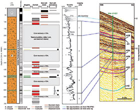 |
| Figure 10.
Core-log seismic integration, Site
U1421. |
Linking the sedimentary stratigraphy of
the Gulf of Alaska with high-resolution
borehole data to establish age models
for glacial sedimentation is a major
objective for Expedition 341. To achieve
this, shipboard physical properties and
downhole logging data were used to
define ties between various seismic
datasets and the five drilled sites.
Core-log integration reduces the
uncertainty associated with sediment
characterization by taking advantage of
both the detailed information provided
by core samples and continuous, in
situ measurements provided by
downhole logging. Then, to integrate the
core and logging data with seismic
profiles, key lithostratigraphic and
logging boundaries were converted from
depth in meters to two-way traveltime
using velocity data from cores, logs,
and VSPs. Figure
10 illustrates the results of
core-log-seismic integration at Site
U1421, providing a preliminary link
between borehole data and the broader
seismic stratigraphy in the region.