|
Logging Summary
|
| IODP Expedition 346: |
|
Asian Monsoon
Expedition 346
Scientific Party
|
| Introduction |
|
|
|
Figure
1. Bathymetry map of
the Japan Sea/East Sea showing
locations of the sites drilled
during IODP Expedition 346 ©
IODP-USIO
|
Expedition 346 was the first scientific
drilling expedition ever to focus
exclusively on the climate system in the
Sea of Japan/East Sea, dedicated mainly
to the investigation of the East Asian
monsoon system, and its influence on
North Atlantic Ocean circulation and
climate. This expedition offered the
opportunity to explore the relationships
between atmospheric, paleoceanographic,
and sea level changes during at least
the last 5 m.y. In particular, cores
obtained during this expedition will be
used to test the hypothesis that
Pliocene-Pleistocene uplift of the
Himalaya and Tibetan Plateau, and the
consequent emergence of the two discrete
modes of Westerly Jet circulation,
caused the amplification of
millennial-scale variability of the East
Asian summer monsoon and winter monsoon
and provided teleconnection mechanism(s)
for Dansgaardâ-Oeschger cycles.
During International Ocean Discovery
Program Expedition 346, the scientific
vessel JOIDES Resolution
drilled and cored nine sites from July
to September 2013 (Figure 1).
Seven of the sites were covering a wide
latitudinal range in the Sea of
Japan/East Sea in order to study and
reconstruct surface water circulation,
sea ice formation, deepwater convection
and oxygenation, biological productivity
of the surface ocean and Eolian dust
flux related to the positioning of the
atmospheric Westerly Jet circulation.
Two sites were closely spaced off the
East China Sea margin to explore
high-resolution changes in Yangtze River
discharge through reconstruction of
sea-surface salinity. A more complete
overview of the expedition operations
and preliminary scientific results are
available in the preliminary
report.
|
|
Logging Tool and
Operations
|
 |
|
Figure
2. Graphic
representation of thelogging
operations during Expedition 346.
|
Downhole logging was carried out at
four of the drill sites (Figure 2 and
Table 1, below) with a standard suite of
wireline logging tools, in order to
complement the coring program by
measuring in situ physical
properties and to characterize the
formation through intervals of
incomplete core recovery.
|
Hole
|
Date
of logging
|
Water
depth (below rig floor)
|
Hole
depth (below sea floor)
|
Maximum
logged depth (below sea floor)
|
Tool
Strings
|
|
U1423B
|
Aug
22, 2013
|
1796.8
|
249.1
|
251.1
|
PC,
FMS-sonic
|
|
U1425A
|
Aug
30, 2013
|
1919
|
407.2
|
404.2
|
PC,
FMS-sonic
|
|
U1427A
|
Sept
7, 2013
|
337
|
548.6
|
548.5
|
PC,
FMS-sonic
|
|
U1430B
|
Sept
19, 2013
|
1082.9
|
275
|
272
|
PC,
TC, FMS-sonic
|
Table 1.
Logging operations summary, Expedition
346. PC= paleo-combo; TC= triple combo
|
|
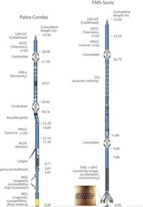
Figure 3. Tool
string combinations planned for
IODP Expedition 346
|
The logging tool strings deployed
during Expedition 346 are shown in Figure 3 and
Table 1. The first tool string is the
paleo combination (paleo combo), a
variation of the triple combination
(triple combo) in which the porosity
tool has been replaced by a Magnetic
Susceptibility Sonde (MSS). It measured,
from top to bottom, resistivity, natural
gamma radiation (NGR), density, and
magnetic susceptibility. The paleo combo
was run first at each logged site. The
second tool string is the Formation
MicroSanner (FMS)-sonic, which provides
sonic velocities and FMS resistivity
images of the borehole wall. In Hole
U1430B, the tool strings were modified
to maximize data acquisition in the
lowest part of the hole. A short version
of the paleo combo was run first to
acquire NGR, density, and magnetic
susceptibility. Another short tool
string was run, including resistivity at
the top and NGR at the bottom. The
FMS-sonic was run as the third tool
string.
During Expedition 346, in situ
temperature measurements were made with
the advanced piston corer temperature
tool (APCT-3) in A holes. The APCT-3
temperature data were combined with
measurements of thermal conductivity
obtained from whole-core samples to
obtain heat flow values.
Logging
Results
We present here a summary of the
logging data and some highlights from
each site. The drill pipe was raised to
~80 m below seafloor prior to logging
because of hole instability in shallow
sediments. Logs were recorded only below
this depth, in open hole. Gamma Ray was
also acquired through pipe but with a
strong attenuation of the signal. After
logging was completed, logging data
initially referenced to depth below the
rig floor were shifted to a seafloor
reference and depth-matched to remove
offsets between different logging runs.
The resulting depth scale, used for all
data presented here, is meters below
seafloor (mbsf). Because of good
borehole conditions and generally low to
moderate heave during downhole logging
data acquisition, log data quality from
Expedition 346 is generally very good.
Scientific highlights include records
of cyclic sedimentation through time,
which seems to relate to Milankovitch
cycles. Regular high-amplitude cyclic
swings are often observed in the gamma
ray, resistivity and density logs, with
several orders of cycles varying from
one to several meters in thickness. With
the exception of ash and dolomite
layers, intervals with high gamma ray
values, high density, and high
resistivity generally reflect an
increase in terrigenous clay content
relative to diatom-rich intervals.
Conversely, the intervals with gamma
ray, density, and resistivity low values
correlate in cores with diatom-rich
intervals.
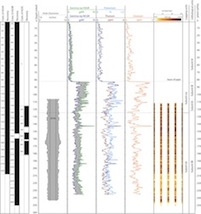
Site U1423
|
|
Figure 4. U1423B downhole
logs (Caliper, Spectral Gamma
Ray, and borehole FMS image) and
corresponding logging and
lithological units.
|
Coring at Site U1423 in the
northeastern part of the Sea of
Japan/East Sea penetrated a 250 m thick
succession of Pliocene to Holocene clay,
silty clay, and diatomaceous ooze with
discrete foraminifer-bearing clay
levels. Volcaniclastic material
represents a minor component throughout
the sediment succession, except in
tephra layers where it is the dominant
component.
Downhole measurements were made in Hole
U1423B to a total depth of 251 m mbsf
using the Paleo-combo and the FMS-Sonic
tool strings (Figure
2, Table 1). The entire logged
interval was assigned to one logging
unit (LU1, Figure
4). FMS images were of excellent
quality because of the good borehole
conditions and sea state during logging
operations. The combination of logs
closely reflects lithological changes in
the recovered cores, including ash
layers. Logging Unit LUI has been
divided into two subunits (LUIa, from
the base of the drill pipe to ~124 mbsf;
LUIb: from 124-250 mbsf) on the basis of
changes in character of gamma ray and
density logs. The base of logging
Subunit LUIa correlates with a distinct
change in log characteristics at ~ 124
mbsf, which approximates the
lithostratigrahic boundary between
lithological subunit IIA and IIB. It
reflects a change downhole to a more
diatomaceous rich lithology
characterized by lower values in total
and spectral natural gamma radiation,
likely reflecting the abundance of non
radioactive elements (diatoms and other
siliceous components) within lithologic
Unit IIB. Preliminary inspection has
also revealed apparent cyclicity in some
parts of the section that will require
further study.
Site U1425
|
|
Figure 5.
U1425A downhole logs (Caliper,
Spectral Gamma Ray, and borehole
FMS image) and corresponding
logging and lithological units.
|
Coring at Site U1425 in the central
part of the Sea of Japan/East Sea
penetrated 427 m of Miocene to Holocene
clay, silty clay, diatomaceous ooze, and
claystone with numerous discrete tephra
(i.e., volcanic ash) layers.
Downhole wireline log measurements were
made in Hole U1425B to ~403 mbsf using
the Paleo-combo tool and FMS-Sonic tool
strings. Each logging tool string was
run twice in the hole to ensure the
quality of the logging data. The logged
interval was divided in three Logging
Units (LU1: from the base of the drill
pipe to 244 mbsf; LU2: from 244-338
mbsf, and LU3: 338 mbsf to the bottom of
the hole) (Figure
5). The combination of logs
closely reflects the lithological
changes in the recovered cores,
including dolomite and ash layers.
Preliminary inspection of the data has
also revealed apparent cyclicities in
the logs collected by the two logging
tool strings below ~244 m WSF, mainly
reflecting variation in diatom content
relative to terrigenous clays. The
cyclic nature of the sediment record at
intervals of ~8-10 m is especially well
expressed in both the gamma ray and
density logs. These cyclicities are also
observed on the FMS resistivity data.
Conductive intervals in the FMS images
tend to reflect intervals enriched in
diatoms whereas resistive intervals
reflect relative high terrigenous clay
content. In the lower part of the Hole,
a shift toward higher density and
resistivity is observed ~340 mbsf,
corresponding to the diagenetic boundary
from biogenic opal-A to opal-CT.
Site U1427
|
|
Figure 6.
U1427A downhole logs (Caliper,
Spectral Gamma Ray, and borehole
FMS image) and corresponding
logging and lithological units.
|
IODP Site U1427 is in the southernmost
part of the Sea of Japan/East Sea. The
site is situated on the outer margin of
the southeast-northwest–trending
continental shelf ~35 km from the
northern coast of Honshu Island. Coring
at Site U1427 penetrated ~548 m of early
Pleistocene to Holocene sediments
dominated by clayey silt and
nannofossil- or biosiliceous-rich clayey
silt. Shell fragments of shallow-water
origin are observed throughout the
sedimentary succession.
Downhole wireline log measurements were
made in Hole U1427A to 548.5 mbsf using
the Paleo-combo and the FMS-Sonic tool
strings. The logs do not show major
steps in the base levels and the entire
logged interval was assigned to one
Logging Unit (LU1) corresponding to
lithostratigraphic Unit A (Figure 6).
Preliminary inspection of the data
revealed cyclicities that mainly reflect
variations in biogenic content relative
to terrigenous clays and are consistent
with lithological changes in the
recovered cores. Intervals with high
gamma ray values, high density, and high
resistivity generally reflect
terrigenous clay rich intervals. Such
intervals possibly correspond to glacial
stages characterized by lowered
productivity. In Hole U1427A, the FMS
images also reveal numerous resistive
and conductive intervals, with
thicknesses ranging from several tens of
centimeters to a few meters.
Site U1430
|
|
Figure 7.
U1430B downhole logs (Caliper,
Spectral Gamma Ray, and borehole
FMS image) and corresponding
logging and lithological units.
|
IODP Site U1430 in the southwestern
part of the Sea of Japan/East Sea is on
the southern upper slope of the eastern
South Korean Plateau, which bounds the
northern margin of the Ulleung Basin.
Coring at Site U1430 penetrated ~274 m
of middle Miocene to the Holocene
sediments dominated by clayey silt,
silty clay, nannofossil ooze,
diatomaceous ooze, claystone, and
sandstone. Numerous discrete tephra
layers occur throughout the sedimentary
sequence, especially within the upper 50
m. Site U1430 will provide a continuous
slow-sedimentation record that is ideal
to study the long-term history of dust
provenance and flux changes since 10 Ma.
Downhole measurements were made in Hole
U1430B to a total depth of ~272 mbsf.
The paleo combo wireline logging tool
string was split into two shorter
strings to maximize data acquisition in
the lowest part of the hole. The logged
interval was divided in two Logging
Units (LU1, from the pipe entrance to
~244 mbsf; LU2, from ~244 mbsf to the
bottom of Hole U1430B) (Figure 7).
In Logging Unit LU1, the log data mainly
reflects variation in diatom content
relative to terrigenous clays, and
matches lithological changes throughout
the section. Preliminary examination of
the data revealed apparent high
frequency cyclicity in the FMS images.
There is a distinct change in log
characteristics at ~244 m WSF, which
correlates closely with a change
downhole to indurated deposits. The core
recovery is low in this interval and the
good quality of the downhole logs and
borehole images should allow us to
refine the lithology within the core
gaps.
As observed at previous IODP Expedition
346 sites, conductive intervals (light
color in the FMS image in Figure 7) in
Logging Unit LU1 generally correlate
with low gamma ray, low density, and low
resistivity logs. Conversely, more
resistive intervals generally correlate
with higher values in the gamma ray,
bulk density, and resistivity logs. This
relationship can be interpreted in terms
of the relative abundance of clay/diatom
in the sediment, with clay having higher
K and Th contents and relatively greater
density than diatom-rich sediment.
The good FMS resistivity data quality
allows the borehole formation
resistivity to be interpreted at several
scales. With the exception of ash and
indurated layers, conductive intervals
in the FMS images tend to reflect
intervals enriched in diatoms, whereas
resistive intervals reflect relatively
high terrigenous clay content. In LU2,
below ~240 mbsf, the FMS images are
characterized by high resistivity (light
colors in the FMS image in Figure 7,
which reflects the increase in clay
content in lithologic Subunits IIIB and
IIIA as well as the presence of cemented
intervals, in agreement with the high
density, velocity, and resistivity
observed within this unit.
Temperature Measurements
In situ sediment temperature
data were measured during deployments of
the APCT on Expedition 346. The
geothermal gradient at the Exp. 346
sites varies from 70 to 140 °C/km, a
large range that reflects tectonic
structures and processes in the area.
|
|
U1422
|
U1423
|
U1424
|
U1425
|
U1426
|
U1427
|
U1428
|
U1429
|
U1430
|
|
Geothermal
gradient °C/km
|
134
|
140
|
125
|
104
|
115
|
70
|
116
|
94
|
103
|
|
Heat
flow mW/m2
|
120
|
133
|
106
|
96
|
94
|
71
|
126
|
88
|
93
|
|
Johanna Lofi: Logging
Staff Scientist, Géosciences Montpellier
- UMR 5243 - CC 060 - Bat. 22,
Université de Montpellier 2, Place E.
Bataillon, 34095 Montpellier Cedex 05,
France
|
|
|