Leg 164 Logging Report
Shipboard Scientific Party
Introduction
Leg 164 was designed to investigate the occurrence of methane hydrates in the sediment section beneath the Blake Ridge. The presence of hydrates in this area has long been suspected due to seismic reflection data showing a strong bottom-simulating reflector (BSR) at the base of a zone of low amplitude reflections (the so-called blanking zone). The primary objectives of the drilling included 1) an assessment of the amounts of gas trapped in extensively hydrated sediments, 2) an investigation of the lateral variability in the extent of gas hydrate development, and 3) an investigation of changes in the physical properties associated with gas hydrate formation (see Leg 164 Scientific Prospectus). A corollary to these objectives was to establish a quantitative relationship between seismic characteristics and hydrate occurrence in the sediment section. To this end it was necessary to measure the concentration of hydrate with depth and to measure physical properties that influence the acoustic response of the sediment column - in particular density and velocity - at a wide range of scales. A complicating factor in this investigation is that hydrate is not stable at normal shipboard conditions, so measurements at conditions as nearly in situ as possible were required. The various wireline log measurements were, therefore, critical to understanding hydrate occurrence within the Blake Ridge.
Shipboard Results
The geochemical (Aluminim Activation Clay tool (AACT) and Gamma Ray Spectrometry tool (GST)) logs and lithology (sonic, density, resistivity) logs were critical to the Leg 164 effort. In gamma ray spectroscopy well logging, each element has a characteristic gamma-ray that is emitted from a given neutron-element interaction. Specific elements can be identified by their characteristic gamma-ray signature, with the intensity of emission related to the atomic elemental concentration. By combining elemental yields from neutron spectroscopy well logs, reservoir parameters including porosities, lithologies, formation fluid salinities, and hydrocarbon saturations (including gas hydrates) can be calculated. The GST can be operated in two timing modes: inelastic, which mainly measures the neutron reactions in the high energy range (elements quantified: carbon, calcium, iron, oxygen, sulfur, silicon), and capture-tau mode which measures the gamma rays emitted from neutron capture (elements quantified: calcium, chlorine, iron, hydrogen, sulfur, silicon). In ODP wells the GST has historically been operated in capture-tau mode; however, on Leg 164 a selected number of inelastic mode measurements where made (45 stations). Preliminary interpretation of the geochemical logs onboard ship suggests that the inelastic carbon/oxygen output data can be used to assess gas hydrate saturations.
|

|
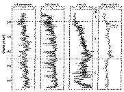
Figure 1. Log data from Hole 995B. Data shown include natural gamma-ray log from the spectral gamma-ray tool (NGT), bulk-density data from the lithodensity tool (HLDT), acoustic velocity data from the long spacing sonic tool (LSS), and deep reading electrical resistivity dada from the phasor dual induction tool (DIT). Also shown are the depths of Logging Units 1, 2 and 3. |
In theory the porosity log (compensated neutron log measured by the compensated neutron tool - CNT-G) provides a direct measure of porosity. The sonic and litho-density (HLDT) logs provide the necessary information to determine Synthetic seismograms. However, because of poor hole conditions, the porosity tool provided little immediately useful information and the sonic and density tools provided data contaminated by noise (Figure 1). Initial onboard attempts to generate synthetic seismograms that bore any resemblance to the observed vertical incidence seismograms in the vicinity of the drilling sites were not satisfactory. Our best onboard estimates of porosity were obtained from the resistivity logs via Archie's Law and calibration with the porosities measured in core samples in the laboratory. Even this estimate of porosity is somewhat suspect since there was very little range in observed resistivity and little or no independent measurements of pore water resistivity from which to determine the formation factor. Shipboard tests determined these constants by using core-derived porosity measurements to calibrate the extremes of the observed log resistivity measurements. We assumed seawater resistivity for the pore water resistivity with a correction for temperature increase downhole.
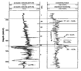
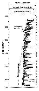
Preliminary shipboard analyses included estimates of porosity and hydrate saturation from resistivity logs (figures 2 and 3) and estimates of elemental content including carbon/oxygen ratios from the geochemical tool string (GLT) measurements. The geochemical data can be used to estimate porosity and hydrate saturation independently from other log measurements.
|

|
Figure 2. Log data used to calculate "potential" gas hydrate saturations in site 997. Data shown include acoustic velocity data from the long spacing tool (LSS) and deep reading electrical resistivity data from the phasor dual induction tool (DIT). Also shown are the depths of Logging Units 1, 2 (2A, 2A1, 2B, 2C, 2C1, 2D) and 3. Listed beside each log trace are the calculated gas hydratae saturations (percent of pore space occupied by gas hydrates). |
|

|
Figure 3. Prosities derived from density and resistivity logs from Hole 995B. Also shown is a porosity-depth function developed from Hamilton (1976). The relatively high porosities below 240 mbsf relative to the Hamilton curve suggests underconsolidation of the sediment section below 240 mbsf. |
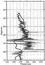
During post-cruise log analysis the various wireline logs will be more extensively analyzed and integrated with core measurements, including pore water chemistry data and vertical siesmic profile (VSP) results (figure 4) in order to obtain more reliable estimates of hydrate concentration, porosity, and a synthetic seismogram. In addition, the acoustic logs obtained with the new shear sonic tool and the Schlumberger sonic tool will be integrated with the results from the VSP and walk-away offset reflection data.
|

|
Figure 4. Sonic log and preliminary VSP inversion obtained at Site 997. Note the general agreement down to about 425 mbsf and the divergence of the two data sets below 425 mbsf. |
Logging Scientist:
Dr. John Ladd
Lamont-Doherty Earth Observatory


