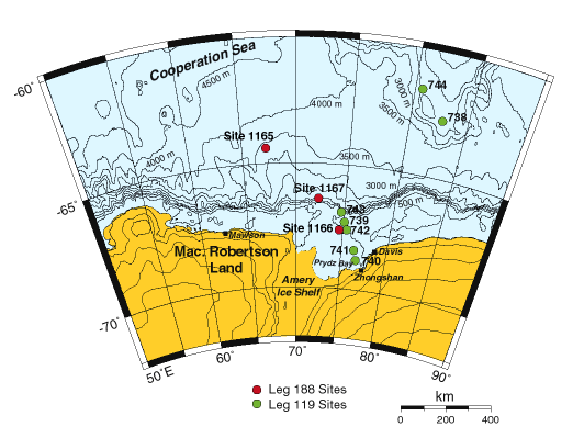
Figure 1. Map of the East Antarctic coastline showing the location of Prydz Bay and the sites drilled during ODP Leg 188 and previously during ODP Leg 119 (Barron, Larson, et al., 1989).
Logging Summary
Introduction
The Antarctic Ice Sheet and surrounding Southern Ocean are key components in the global climate regime from the early Cenozoic to the Present day. Drilling during ODP Leg 188 was based on one of five linked proposals to determine the Cenozoic glacial history and paleoenvironments of Antarctica. It focused on three sites on the continental shelf (1166), slope (1167) and rise (1165) in the Prydz Bay area of East Antarctica (Figure 1). The ice sheet in this region is long-lived and responds more slowly to major climate events relative to the smaller Neogene ice masses of the Antarctic Peninsula, investigated during ODP Leg 178 (Barker, P.F., Camerlenghi, A., Acton, G.D., et al., 1999). Leg 188 was designed to complement previous drilling during Leg 119 (Barron, J., Larson, B. et al., 1989) and address the long-term record of Antarctic glaciation.
The principle objectives were to:
Acquire a record of ice sheet growth and decay, and investigate the stability of the East Antarctic Ice Sheet
Increase our understanding of how the ice sheet behaves in response to changes in the Southern ocean
This report presents the preliminary results of the logging operations that were carried out at all three sites visited during the leg.
Figure 1. Map of the East Antarctic coastline showing the location of Prydz Bay and the sites drilled during ODP Leg 188 and previously during ODP Leg 119 (Barron, Larson, et al., 1989).
Logging Operations Summary
Wireline logging was carried out at all 3 of the Leg 188 sites, and Logging-While-Drilling (LWD) was carried out at 2 of them (Table 1) and figures 3A, 3B, 3C).
Operational highlights:
a) The CDR (Compensated Dual Resisitivity) LWD tool was used to log resistivity and natural gamma radiation at two sites. LWD was planned for Leg 188 to test the system in glacial environments where ODP core recovery at shelf and upper-slope sites has commonly been relatively low, and because the holes could have been too unstable to complete conventional wireline logging (this was the case at Site 1167). The LWD tools are located in the drillstring itself, just behind the bit (Figure 2), and measurements are made immediately after the hole is cut. The measurements can be superior to the equivalent wireline logging measurements, because the hole has no time to be washed out (widened) by continued drilling or coring operations, and fluid invasion is also limited. A description of the LWD tools and their applications for ODP can be found in Schlumberger (1993) and Moore, Klaus, et al. (1998).
b) The Measurement-While-Drilling (MWD) 'Power Pulse' tool transmited drilling parameters (weight on bit (WOB), torque) to the ship in real time by means of a pressure wave in the drilling fluid of the pipe (at 12 Hz, 3 bits/sec). There is significant information on the efficacy of the passive heave compensation system in the comparison between downhole WOB and the WOB measured at the surface, which is used by the drillers in the course of normal drilling operations.
c) The GHMT-Sonic toolstring was used for the first time in ODP at Hole 1166A (usually the sonic tool is run with the FMS, and the GHMT is run alone). Advantages of this toolstring combination are that: (1) the GHMT is shorter than the FMS so the sonic tool is able to record about 10 m lower in the hole; (2) both the DSI and the FMS acquire high resolution data, which limits the logging speed because there is a limit to the data transmission rate up the logging cable; (3) the GHMT alone is a light-weight tool, making it less likely to be able to pass through obstructions in the borehole.
d) The IESX seismic display and interpretation software (part of Schlumberger GeoQuest's GeoFrame package), installed on the Sun computer in the DHML, was used to load and display SEG-Y format digital data from the seismic surveys of the area, including the survey taken by the Resolution over Site 1165. Synthetic seismograms were computed from the sonic velocity and density logs (e.g. Figure 5c).
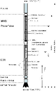
Figure 2. Schematic diagram showing the configuration of the Logging While Drilling LWD/MWD bottomhole assembly employed during Leg 188.
Wireline tool strings used on Leg 188 (see also Table 1 and Figure 3):
The FMS-Sonic string consists of the FMS (Formation Micro-Scanner), the GPIT (General Purpose Inclinometer Tool), and the DSI (Dipole Sonic Imager) sonic tool. The DSI was run in 'P&S' and 'Dipole' modes, to acquire P and S wave slownesses, respectively.
The GHMT-Sonic consists of the GHMT (Geological High-resolution Magnetic Tool, which measures magnetic field and susceptibility), and the DSI sonic tool (as above).
a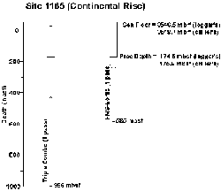 b
b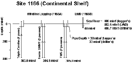
c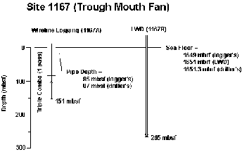
Figures 3 a, b & c. Summary diagrams showing the logged intervals, pipe depth and sea floor depths at Sites 1165, 1166 and 1167 respectively.
| Hole | 1165C | 1166A | 1166B | 1167A | 1167B |
| Water depth | 3548.7 mbrf | 480 mbrf | 482.5 mbrf | 1651.3 mbrf | 1651 mbrf |
| Depth cored | 999.1 mbsf | 381.3 mbsf | 0 mbsf | 447.5 mbsf | 0 mbsf |
| Interval logged | 174.5-996 mbsf | 30-374 mbsf | 0-42 mbsf | 85-151 mbsf | 0-265 mbsf |
| Recovery | 80.2 % | 18.6 % | not cored | 42.8 % | not cored |
| Depositional environment | Continental Rise Central Wild Drift | Prydz Bay Continental Shelf | Prydz Bay Continental Shelf | Prydz Channel Trough Mouth fan | Prydz Channel Trough Mouth fan |
| Stratigraphy | Early Miocene to Pleistocene age terrigenous clays and hemipelagic biogenic deposits. | Late Pliocene to Holocene glacial, Late Eocene to Oligocene early glacial and likely Early Cretaceous to Eocene pre-glacial. | Late Pliocene to Holocene glacial sediments as in upper section of Hole 1166A. | Pleistocene to late Pliocene glacial and interglacial sediments. Poor age control due to paucity of siliceous microfossils. | Pleistocene to late Pliocene glacial and interglacial sediments as in Hole 1167A. |
| Principal lithologies | Clay and silt with dispersed clasts as IRD & carbonate cemented beds | Diamictite, poorly sorted sandy and clayey sediments. coarse sand & clay | Similar to those encountered in Hole 1166A | Clayey, silty sand, dispersed clasts. Horizons of gravel, coarse sand & clay | Similar to those encountered in Hole 1167A |
|
Tool strings used
|
(1) Triple-combo:
|
(1) Triple-combo:
HNGS; HLDS;
APS; DITE; TAP
NGT; SUMS; NMRS; DSI (2 passes) (3) FMS-NGT: (2 passes) |
LWD/MWD:
MWD Powerpulse
CDR
NGT
|
Triple-combo:
|
LWD/MWD:
MWD Powerpulse
CDR
NGT
|
Table 1. Summary of the holes logged during ODP Leg 188.
Site 1165, Continental Rise
Site 1165 is situated on the continental rise offshore from Prydz Bay over mixed pelagic and hemipelagic sediments of the central Wild Drift. The drift is an elongate sediment body formed by the interaction of sediment supplied from the shelf and westward-flowing currents on the continental rise. The site is in 3537 m of water and was selected to provide a record of sedimentation that extends back to the onset of contour current-influenced deposition on the rise. The main objective was to obtain a proximal continental rise record of Antarctic glacial and interglacial periods (including the probable mid-Miocene intensification of Antarctic glaciation) for comparison with other sites around Antarctica and with those of Northern Hemisphere ice sheets.
Highlights of the downhole logging results at Site 1165:
a) The opal A to opal CT transition was identified at 610 mbsf by the abrupt reduction in porosity at that depth.
b) Thin carbonate-cemented beds were identified by the distinct 'spikes' they cause in the logs (picked out in the expanded sections in Figure 4b) High values on the resistivity, density and velocity logs reflect the porosity decrease that accompanies carbonate cementation. The PEF peak reflects an increase in the proportion of calcium carbonate (PEF ~5 barns/e-), while the concurrent drop in natural gamma reflects a decrease in the proportion of clays.
c) There is a probable cyclicity of the smaller peaks (picked out in the expanded section in Figure 4b) We suspect from preliminary counting of the peaks in the resistivity logs that they are being paced by the precessional astronomical cycle. Post cruise work will aim to: (a) determine which components of the sediment are responsible for the observed cycles (carbonate cementation, varying abundance of diatoms); (b) assess whether the cycles have a regular periodicity, and if so, use them to attempt a cyclostratigraphic dating of the poorly dated lower section of the hole; and (c) provide a model for the sedimentological and paleoenvironmental causes of the cycles, in the context of the Southern Ocean and the Antarctic ice sheet.
d) In Log Unit 1, total gamma-ray and bulk density logs co-vary, which could be explained by a varying abundance of diatoms downhole (diatom-bearing layers have lower density (due to the internal framework porosity of the diatoms) and lower gamma values (due to the dilution of the radioactive clay fraction by the diatoms).
At Hole 1165C, a failure of the Z-axis accelerometer on the GPIT (General Purpose Inclinometer Tool) and a software communication failure to the FMS tool resulted in only 50m of FMS data.
a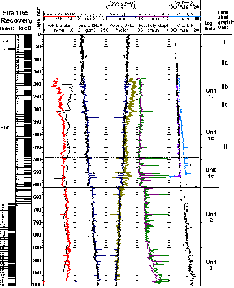 b
b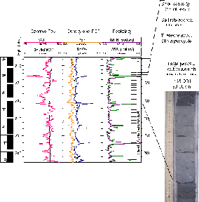
Figure 4a. Downhole log response (caliper, gamma-ray, density, porosity, resistivity and sonic velocity) and units identified in Hole 1165C. Core recovery and physical properties measurements are also plotted.
Figure 4b. Expanded sectionfrom Hole 1165C showing peaks related to more cemented beds.
Site 1166, Continental Shelf
Site 1166 is situated on the Prydz Bay continental shelf on the southwestern flank of Four Ladies Bank, ~40 km southwest of ODP Site 742, which was drilled on Leg 119. Prydz Bay is at the downstream end of a drainage system that originates in the Gamburtsev Mountains of central East Antarctica. The early development and growth of the Cenozoic Antarctic Ice Sheet is believed to have started in the early middle Eocene to early Oligocene, but, prior to Leg 188, drilling on the continent and the continental margin has not sampled a stratigraphic section that clearly spans and includes the transition period from preglacial to glacial conditions. Site 1166 was chosen to recover core from the Cenozoic sediments below the horizon reached at Site 742, and provide an age for the arrival of glaciers in Prydz Bay and a record of changes in paleoenvironments and biota with the onset of glaciation. Site 1166 records a progression in depositional environments from Lagoonal (Lithological Unit IV) to Fluvial/Deltaic (III) to Pro-glacial (II) (Upper Eocene - Lower Oligocene) to Glacial (I). Work currently being carried out on the abundant pollen in the lower units will help resolve the continental paleoenviroment, and also will help with dating.
Downhole logging was highly successful at Site 1166, with each toolstring reaching the base of the hole. Also, the low core recovery meant the logs were a prime source of data for most of the hole (Figure 5a).
Highlights of the downhole logging program at Site 1166:
a) We interpreted the logs in terms of lithology, given the known geological environment and the recovered core. From the FMS image log we were able to pick out the clasts of the diamict, the massive sands, stratified silty-sands, and so on (Figure 6). From the conventional logs (e.g. sonic velocity), it was apparent that the top part of the sand unit (Lithological Unit III) was in fact interbedded sands and clays. The diamict and sands (low porosity) are easily distinguishable from the higher porosity clays.
b) The log-based correlation to Site 742, some 40 km away, showed that the top layers (to the base of the diamict) are common between the two sites, and 22% thicker at Site 742 (Figure 5b).
c) A synthetic seismogram was generated from the sonic velocity and density logs, and overlaid on the seismic section (Figure 5c), using the downhole lab's new IESX seismic interpretation software. In this way we were able to identify cored units with reflectors on the seismic section.
d) Extremely high values of natural gamma radiation, mostly due to thorium and uranium, occur below 290 mbsf, most likely due to a concentration of heavy minerals in these strata. A back of the envelope calculation, based on published estimates of the thorium and uranium contents of minerals, showed that roughly 0.2% zircon and 0.03% monazite could produce the observed gamma ray signature. Log Unit 2 has higher potassium values than the underlying units, reflecting the relative abundance of potassium-rich K-feldspars and micas, noted by XRD analysis of core samples.
e) Resistivity and natural gamma LWD logs completed the top section of the logs where the pipe prevented wireline logging.
a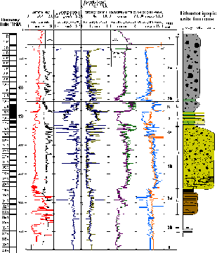 b
b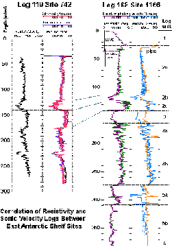
c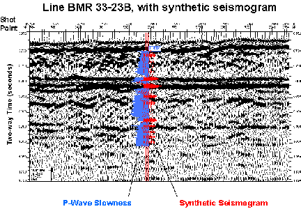
Figure 5a. Downhole log response (caliper, gamma-ray, density, porosity, resistivity and sonic velocity) and units identified in Hole 1166A. Core recovery and physical properties measurements are also plotted.
Figure 5b. Correlation of resistivity and sonic velocity logs between ODP Sites 1166 and 742 (Leg 119). Site 742 lies about 40 km to the east of Site 1166.
Figure 5c. Synthetic seismogram and p-wave slowness log overlain on seismic line.
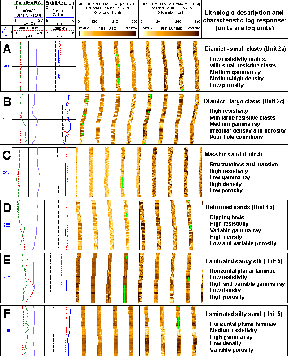
Figure 6. Representative examples of FMS images from Hole 1166A, with gamma ray, porosity, density and resistivity log responses and lithological descriptions.
Site 1167, Continental Slope (Trough Mouth Fan)
Site 1167 is located in the middle of the Prydz Channel Trough Mouth Fan. Construction of the fan started in early to mid-Pliocene time when the Lambert Glacier formed a fast-flowing ice stream on the western side of Prydz Bay. The fan has grown most during episodes when the Lambert Glacier has grounded at the shelf edge, delivering basal debris to the fan apex. This material was then redistributed by sediment gravity flows and meltwater plumes. Models of trough mouth fan sedimentation suggest that thick siliciclastic units should correspond to peaks in Antarctic ice volume, whereas periods of reduced ice volume should be represented by hemipelagic sediments. Thus, the alternation of facies should reflect the number of times the East Antarctic Ice Sheet has expanded to the shelf edge in latest Neogene time.
Wireline logging operations in Hole 1167A were attempted with the Triple Combo tool string, but were limited to a 66m interval because of an obstruction in the hole, the lockable flapper valve not opening properly, and to time constraints (Figure 3c). LWD operations in Hole 1167B generated high quality resistivity and spectral gamma ray data to a depth of 262 mbsf before time ran out and the ship had to start the transit to port. The short interval of wireline logs obtained at this site correlates well with the LWD logs. Logging highlights:
a) The thin intervals of low resistivity are interpreted as fine-grained, non-diamict sediment, which was recovered in Cores 5H and 25X. The known low resistivity of clay compared to diamict supports this interpretation, though sorted sands or gravels might produce a similar signature. The position of the clay beds appears to be related to saw-tooth trends in the magnetic susceptibility data (Figure 7). The low-resistivity intervals occur at the step in susceptibility values at 116-127 mbsf and 190-216 mbsf, but this relationship is not so clear cut towards the upper part of the hole.
b) High gamma ray values are observed for a red bed interval at 62-90 mbsf, and low values between 90-120 mbsf and 215-255 mbsf. The change to
higher values may be due to an increased concentration of granitic clasts.
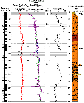
Figure 7. LWD gamma ray and resistivity data from Hole 1167B, and magnetic susceptibility trends from cores in Hole 1167A. Thin intervals of low resistivity (probably clay/silt layers) are marked in grey.
References
Barron, J., Larson, B. and Shipboard Scientific Party, 1989. Proc. ODP, Init. Repts., 119: College Station, TX (Ocean Drilling Program).
Moore, J.C., Klaus, A., and Shipboard Scientific Party, 1998. Proc. ODP, Init. Repts., 171A: College Station, TX (Ocean Drilling Program).
Schlumberger, 1993. Logging While Drilling. Houston (Schlumberger Educational Services) Publ. SMP-9270.
Shipboard Scientific Party, 1999. Leg 178 summary: Antarctic glacial history and sea level change. In Barker, P.F., Camerlenghi, A., Acton, G.D., et al., 1999. Proc. ODP, Init. Repts., 178. College Station, TX (Ocean Drilling Program).
Shipboard Scientific Party, 2000. Leg 188 Preliminary Report: Prydz Bay-Cooperation Sea, Antarctica: glacial history and paleoceanography. ODP Prelim. Rpt., 188.
Leg 188 Logging Scientists
Trevor Williams: Lamont Doherty Earth Observatory, Route 9W, Palisades, NY 10964, USA.
Samantha Barr: University of Leicester, University Road, Leicester, LE1 7RH, UK.
Dave Handwerger: dahandwe@mines.utah.edu , Dept. of Geology and Geophysics, Univ. of Utah, 1460 East 135 South, Salt Lake City, Utah 84105, USA.