The principal objectives of Leg 178 and its wireline logging program were:
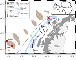
Figure 1: Location Map
The Antarctic Ice Sheet has been a major component of the global climate system throughout middle and late Cenozoic times. Deep and bottom waters are formed next to Antarctica, and changes in the ice sheet's volume have been responsible for past eustatic sea-level changes. Unfortunately, the history of Antarctic glaciation is poorly understood, not least because it has been largely inferred from indirect, low-latitude proxy data, such as the oxygen-isotope record. However, analysis of the terrigenous deposits on the continental slope, shelf and rise along the margins of the Antarctic Peninsula, carried out during Leg 178, has produced new, direct evidence of the evolution of the Antarctic Ice Sheet.
Nine sites were drilled (Fig. 1), three of which were logged using standard wireline techniques (Table 1). Although logging operations were hindered by the intermittent approach of icebergs and pronounced ship heave, important results were obtained from each of the holes investigated. Some of the key findings from the logging program are outlined below.
|
|
Hole 1095B |
Hole 1096C |
Hole 1103A |
|
Depositional Environent |
Sediment drift on the continental rise |
Sediment drift on the continental rise |
Glacial, overdeepened outer continental shelf |
|
Age of base of logs |
~10.5 Ma |
~4.5 Ma |
Pliocene/Late Miocene |
|
Water depth (m) |
3839 |
3153 |
494 |
|
Depth cored (mbsf) |
570.2 |
607.7 |
367 |
|
Triple Combo natural gamma (HNGS) porosity (APS) litho-density (HLDS) resistivity (DIT) |
100-570 |
97-343 (upper) 359-556 (lower) |
84-244 |
|
GHMT natural gamma (NGT) magnetic field magnetic susceptibility |
100-560 |
359-514 (lower) |
84-244 |
|
FMS-Sonic natural gamma (NGT) sonic velocity (SDT) FMS resistivity image |
- |
- |
84-244 |
|
WST seismic check shots |
142-527 |
- |
- |
Table 1. Details of the holes logged during Leg 178
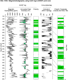
This hole was drilled into the lower, distal, flank of a hemipelagic sediment drift on the continental rise (Fig. 1) in order to examine the early stages of drift development and glacial evolution. The drift sediments exhibit metre scale alternations between sediment rich in silt laminae (distal turbidites) and heavily bioturbated muds, interpreted to be glacial cycles. These alternations are evident in the logs (e.g. magnetic susceptibility (Fig. 2) and the natural gamma logs).
The GHMT tool string provided a reliable magnetic polarity stratigraphy (Fig. 2). This was given by the magnetic field (MAGB) measurement, after removing the effects of the bottom hole assembly, and the induced sediment magnetisation (itself derived from the logged magnetic susceptibility (RMGS)). The GHMT polarity stratigraphy corresponds well with polarity zones based on half-core inclination measurements (Fig 2), and enables the magnetic stratigraphy to be extended into areas where core recovery is poor or absent, particularly towards the base of the hole . The lowermost normal polarity interval probably corresponds to chron C5n.2n (9.920-10.949 Ma).
Figure 2: Hole 1095B: Polarity stratigraphy from the GHMT tool string
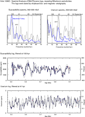
Although this hole has been drilled into the same hemipelagic sediment drift as 1095B it is more proximal to the shelf and lies closer to the crest of the drift (Fig. 1). The shallower, younger part of the stratigraphic section is, therefore, better represented in Hole 1096C: it extends from the Holocene to the early Pliocene (~ 4.7 Ma). This hole had to be logged in two sections, the first Triple Combo run having encountered a blockage at 343 mbsf.
In the lower part of the hole, cyclic alternations are more apparent in the logs than in the appearance of the sediment itself (subtle alternation between laminated and bioturbated silty clay). The concentrations of uranium and potassium, and the Th/K ratio, show regular fluctuations, as does the magnetic susceptibility (governed predominantly by the concentration of magnetite in the sediment). Preliminary spectral analysis suggests that magnetic susceptibility has a 100 kyr (orbital eccentricity) dominant periodicity and that uranium concentrations have a 41 kyr (axial tilt) periodicity (Fig 3). The magnetic susceptibility log does have smaller troughs ('bites') at roughly 40 kyr intervals, but their relation to the uranium 40 kyr cycles appears not to be simple. The dominant periodicity elsewhere on the globe (in oxygen isotope records, etc) in the middle Pliocene is 40 kyr.
Figure 3: Hole 1096C: Periodicity in the Uranium and susceptibility values
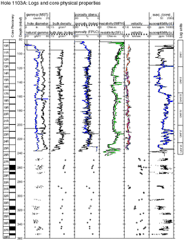
Hole 1103A was drilled at the inshore end of an attempted shelf transect (Fig1), in a setting close to a source of poorly sorted glacial debris. During logging, a hole blockage was encountered at 242 mbsf, which was impassable with the Triple Combo tool string. This meant that only the upper half of the 355 m deep hole could be logged (Fig 4). However, log quality from the top half of the hole was good, with the borehole width varying between 30-41 cm, and less than a meter of infill accumulating between the first and the last logging runs.
The good quality logs obtained from Hole 1103A are all the more important in view of the fact that core recovery from the uppermost 247 m was negligible (2.3%). This means that the scientific interpretation of the top half of this hole will have to be derived from the logging results, with some help from the seismic section and drilling rate data.
Figure 4: Log and core physical properties from Hole 1103
Stable conditions in the borehole enabled quite good FMS images to be obtained. The FMS images are characterised by an absence of layering and the presence of resistive spots (light colored areas), which indicate the presence of pebbles, cobbles and boulders.
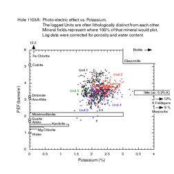
The logging units (Fig. 5) are displayed on a cross-plot of photo-electric effect (PEF, measured by the litho-density tool) vs. potassium (from the HNGS spectral gamma tool), bringing out the mineralogical differences between the units.
Figure 5: Photo-electric effec vs. Potassium
Logging Summary prepared by:
Trevor Williams & Pat Fothergill
Leicester University Borehole Research