Objectives
The principal objectives of ODP Leg 182 were to investigate the evolution of the Cenozoic cool-water carbonate margin of the Western Great Australian Bight and produce a more detailed understanding of global environmental changes in high to mid-latitude settings (see Leg 182 Scientific Prospectus) . Cool-water carbonates are deposited in sea-water temperatures of less than 20°C. Carbonates began accumulating on the southern Australian divergent passive continental margin during the Eocene and continued throughout the Cenozoic depositing an almost 1 km thick carbonate succession in the Eucla basin. During this period the margin has been essentially tectonically stable. Slight regional tectonic tilting (<1°) in the Miocene caused exposure of the Nullarbor Plain, limiting Neogene sedimentation to the modern day outershelf and upper slope. The Eucla basin extends some 350 km inland from the modern day coastline and extends seaward approximately 200 km to the modern shelf edge and upperslope. Seven seismic sequences have previously been identified in the off-shore Cenozoic succession all of which, bar a basinal progradational siliciclastic wedge, are entirely carbonate (Feary and James 1998). The specific goals of the Leg 182 were:
1. To describe the reaction of cool-water carbonate depositional systems to different phases of the sea-level cycle.
2. To interpret the cool-water carbonate margin in terms of paleoceanography including the timing and paleoceanographic effects of the opening of the Tasman Gateway and the influence of the Leeuwin Current on paleoproductivity through time.
3. To provide high-resolution data on the tempo and pattern of biotic evolution in oceanic and neritic environments.
4. To investigate the nature of early burial diagenesis (lithification and dolomitization) in a cold, sea-water dominated setting.
Logging Program
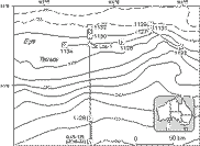
Eight of the nine sites drilled in the western Great Australian Bight (Figure 1) during Leg 182 were logged using geophysical wireline logging tools (Table 1). These sites were located to produce a west-east profile along the strike of the shelf-edge (Sites 1134, 1130, 1126, 1127, 1133); a north-south transect from the shelf-edge to the middle of the continental rise (Sites 1132, 1130, 1128) situated towards the west of the Eucla basin; and a north-south transect at the shelf-edge situated towards the east of the Eucla basin (Sites 1129, 1131, 1127) (Figure 1).
Figure 1: Summary of holes logged during Leg 182.
Four standard ODP tool strings were deployed during Leg 182 Table 1. The choice of tool strings used reflected the scientific objectives at each site and also the operational conditions during logging.
A Wireline Heave Compensator (WHC) was used during all logging runs to minimise tool motion in the borehole due to ship heave caused by sea swell. At a few sites the WHC had difficulty coping with the complex cross-heave sea-state and in these cases logging speeds had to be increased mid-run and/or tool calipers closed before the end of a run to protect the string. However, tool heave does not appear to have had any major adverse effects on the quality of the logging data.
High levels of hydrogen sulphide gas were detected in cores recovered from Sites 1127, 1129, 1130, 1131, 1132 and 1134. Exposure to hydrogen sulphide gas is deleterious to metal causing stress cracking. Special precautions were take to protect the wireline cable and logging tools in these holes, which included coating the wireline cable with a protective oil based inhibitor and loading the hole with sepiolite mud to help limit gas entering the hole.
During Leg 182 the Geological High Sensitivity Magnetometer Tool (GHMT) was able to measure magnetic susceptibility using the Susceptibility Magnetic Sonde (SUMS), but was unable to measure total magnetic field as the Nuclear Resonance Magnetometer Sonde (NMRS) on this tool was not functioning.
The new Lamont-Doherty Earth Observatory-High Resolution Temperature/Acceleration/Pressure tool (LDEO-TAP tool) replaced the Lamont Temperature Tool (TLT) as the borehole temperature tool on this leg. The LDEO-TAP was deployed in memory mode in Holes 1126D, 1127B and 1131A as part of the triple combo tool string. The LDEO-TAP offers substantially improved quality and resolution of data measured over an extended ambient temperature range compared to the TLT. Tool acceleration measured by the LDEO-TAP is used for assessing the efficiency of the WHC and can also be used to correct triple combo logs for the effects of tool motion resulting from ship heave.
Overall the logs acquired on this leg were of high quality. Some of the initial findings of the logging program are outlined below.
|
Hole 1126D |
Hole 1127B |
Hole 1128D |
Hole 1129D |
Hole 1130C |
Hole 1131A |
Hole 1132C |
Hole 1134A |
|
|
Water depth (m) |
783.8 |
479.3 |
3874.6 |
202.4 |
487.8 |
333.6 |
218.5 |
701 |
|
Hole depth (mbsf) |
463.3 |
510.7 |
452.6 |
604 |
395 |
616 |
561 |
397 |
|
Base of BHA* (mbsf) |
117 |
87.4 |
110 |
100 |
108 |
99 |
105 |
105 |
|
Depositional Environment |
shelf margin |
upper slope |
toe of slope |
just seaward of shelf edge |
upper slope |
upper foreslope |
just after shelf slope break |
upper slope |
|
Stratigrapgy |
m. Eocene - Pleistocene |
Pleistocene - Miocene |
Neogene - Paleogene |
Miocene - Pleistocene |
Pleistocene - probable Eocene |
l. Pliocene - Holocene |
Holocene - Eocene |
m. Eocene - m. Pleistocene |
|
Principal Lithologies |
siliciclastics, calcareous ooze, silicified chalk, chert and limestone. |
wackestone to packstone, chert |
calcareous clay/ooze, packestones, wackestones, chert, silty sandstone. |
bryozoan floatstone-rudstone, bioclastic packstone-grainstone |
calcareous sandstone, chert, pelagic calcareous ooze and chalk, packstones and wackestone. |
packestone, floatstone, rudstone, packstone-grainstone, chert, grainstone. |
bryozoan floatstone, rudstone, packstone, and wackestone. Grain/pack/ wacke /stones. ooze and chalk, chert. |
calcareous ooze,wackestone, packestone, float/rudstone,chalk, porcellanite, limonitic sst. |
|
Tool strings deployed |
(1) Triple-combo: DIT-HLDS-APS-HNGS-TAP |
(1) Triple-combo: DIT-HLDS(no source)-APS-HNGS-TAP |
(1) Triple-combo: DIT-HLDS-APS-HNGS |
(1) Triple combo: DIT-HLDS-APS-HNGS |
(1) Triple combo: DIT-HLDS-APS-HNGS |
(1) Triple combo: DIT-HLDS-APS-HNGS-TAP |
(1) Triple combo: DIT-HLDS-APS-HNGS |
(1) Triple combo: DIT-HLDS-APS-HNGS |
|
Intervals Logged** (mbsf) |
(1) 0-443 |
(1) 0-510.7 |
(1) 0-424 |
(1) 0-604 |
(1a) 0-371.5 |
(1) 0-578 |
(1) 0-561 |
(1) 0-368 |
*BHA: bottom hole assembly
**numbers in parenthesis indicate tool string
Table 1: Summary of holes logged during Leg 182
Logging Highlights
Gamma-ray logs have revealed high frequency cycles (10-20 m) in the Pleistocene succession that can be traced from the shelf break to the upper slope in the eastern transect (see Holes 1127B, 1129D 1131A and especially Figure 15 ). These cycles may record changes in accommodation space caused by relative sea-level changes and/or changes in the distribution of the sedimentary budget between the carbonate factory and foreslope during progradation (see Discussion). Gamma-ray logs also proved useful for differentiating logging units in the piped interval that correlate to lithostratigraphic units identified towards the top of the succession from core (e.g., see Hole 1134A, especially Figure 14 ).
Porosity and density logs from this leg were plotted together on compatible scales (for explanation see Hole 1126D) to assist in characterising stratigraphic changes in lithological composition, especially the occurrence of dolomite (e.g., Hole 1134A). Porosity-density logs in combination with natural gamma-ray, resistivity and sonic logs proved valuable for identifying and differentiating chert bands, silicified horizons, and potential hard and firm grounds in intervals of poor or no core recovery (for examples see Holes 1126D, 1127B, 1128D, 1129C, 1130C, 11331A, 1132C. and 1134A). Firmgrounds identified from the logs may correspond to key sequence stratigraphic surfaces.
Down hole changes in the character of continuous precision temperature logs identified some lithological boundaries, also recognised in core, related to changes in formation geothermal conductivities and permeabilities, and the depths of significant fluid and gas flows in and out of boreholes (e.g., see Hole 1127B especially Figure 4). Firmgrounds, chert beds, gas escape features, potential cycles, and some of the major stratigraphic boundaries can be seen on the FMS resistivity images (for examples see Figures 5, 8, 11).
Logs across the K/T boundary were acquired in Hole 1126D and possibly Hole 1134A, but core recovery of the mainly unconsolidated siliciclastic deposits below the boundary was poor. Post-cruise interpretation of geophysical logs will include inversion analysis of the data to determine stratigraphic changes in cool water-carbonate platform mineralogy, including intervals in which there was no core recovery; and interpretation of cyclicity identified from the logs (see Future research below).
Hole 1126D
Geological Setting
Hole 1126D is located on the eastern Eyre Terrace at a water depth of 783.8 m (see Figure 1) and provided a record of middle Eocene to Pleistocene sedimentation in the middle to upper slope platform setting. Two major sedimentary packages are present. The lower package consists of marine siliciclastic sediments of probable Cretaceous age the upper package of marine pelagic carbonates.
Logging Operations
The logging program carried out in Hole 1126D is summarised in Table 1. During logging with the triple combo the WHC was not functioning in the intervals 320-303 and from 197 mbsf to sea-floor after reaching the maximum limit of heave correction. The FMS tool was not included on the second tool string because of the risk of damaging the caliper arms in the complex heave conditions. As only the SUMS in the GHMT was functioning it was possible to instead combine the GHMT with the sonic tool (SDT) on the second tool string. A GPIT was also included on the second string to provide data on the effects of heave on tool motion. The caliper log indicated several zones of washed out hole, especially in the siliciclastic part of the section. This may have affected logs from excentered tools (i.e. neutron-porosity and density) but not hole centred tools (i.e. magnetic susceptibility, sonic and resistivity). The WST recorded 9 check-shot stations adjacent to significant boundaries as indicated by the acquired logs.
Results
Plots of the some of the conventional geophysical logs acquired from Hole 1126D below pipe are shown along with core recovery, lithological units and biostratigraphic ages in Figure 2. The logs acquired in Hole 1126D are similar to those for Hole 1134A, which was situated in a comparable part of the platform situated further to the west. All plots of conventional logs are plotted on linear scales chosen according to the maximum excursions of individual data sets. All porosity and density logs from Leg 182 are plotted on compatible scales using the following relationship between density and porosity in a clean filled limestone:
d = ø x 1.0 + (1-ø) x 2.71
where: d =bulk density, ø =porosity, 2.71 = density of calcite (g/cm3), 1.0 = density of (fresh) water (g/cm3)
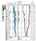
Figure 2: Hole 1126D below pipe: core recovery, geophysical logs (caliper, gamma-ray, porosity-density, resistivity, sonic velocity, magnetic susceptibility), logging units, lithostratigraphic units, biostratigraphic ages.
On this plot, porosity and density curves will coincide for clean, water filled limestones, whereas the mixing of different lithologies will be seen as either negative or positive separations between the curves (Rider 1996).
Core recovery was very good in the top 160 mbsf, allowing three lithological units to be differentiated in this interval. However, below 160 mbsf core recovery was very poor making it impossible to differentiate lithological units in this interval based on core. Sediment between 160 mbsf and the top of the sandstone was thus classified into a single lithological unit, unit IV. Conventional geophysical logs especially natural gamma-ray in the piped interval and magnetic susceptibility in the open hole interval (Figure 2) allowed the succession to be divided into 8 logging units, some of which correlate with seismic stratigraphic units (Feary and James 1998). Gamma-ray cycles measured through pipe in the upper 40 mbsf may be caused by relatively high organic and aragonite concentrations in this interval measured from core. In the interval below 160 mbsf changes in several logs provided the detail and continuity necessary to subdivide lithologic Unit IV. Except for the basal 20 metres, photelectric effect (PEF), values and neutron-density separations indicate calcium carbonate-rich sediments in the open hole section. Porosity-density cross-overs and shallow resistivity peaks occur throughout the logged section, indicating the presence of many chert and silicified horizons interbedded with less indurated calcareous oozes. The base of logging unit 7 corresponds to the hiatus between Tertiary carbonates and Cretaceous siliciclastic deposits. In Unit 8 overall PEF values are lower indicating siliciclastic deposits and the occurrence of PEF peaks in this unit indicate the presence of iron minerals.
Hole 1127B
Geological Setting
Hole 1127B is located on the eastern Eyre Terrace at a water depth of 479.3m (see Figure 1) and provided a Miocene to Pleistocene age record of a prograding middle slope setting. Hole 1127B forms the distal end of a north-south transect which includes Holes 1131A and 1129D. Core recovery was good but core deformation caused by degassing made it difficult to identify the exact position of some depositional boundaries from core, and also meant that core physical properties are unlikely to be accurate reflections of in situ index properties.
Logging Operations
The logging program carried out in Hole 1127B is summarised in Table 1. Hole 1127B was the first hole logged in which high level of hydrogen sulphide gas were detected. Precautions were taken to protect the wireline and logging tools from this potentially hostile environment (see Introduction). As an additional precaution at this site the triple combo was run without the nuclear source in the HLDS, and at double the usual logging speed (550 m/hr) to limit exposure to any gas that might have entered the hole. The HLDS essentially functioned as a caliper tool in this hole. Thus, no density and PEF logs are available for Hole 1127B. Despite the faster than usual wireline speed, logs from the triple combo were of very good quality. Following the success in logging 1127B the triple combo was run in its normal set up and at optimum logging speed in all other holes in which hydrogen sulphide was present. The WHC coped well with the moderate heave conditions during logging. Borehole conditions were excellent for logging.
Results
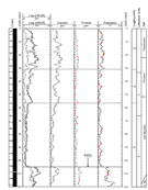
Plots of the some of the conventional geophysical logs acquired from Hole 1127B below pipe are shown along with core recovery, lithological units and biostratigraphic ages in Figure 3. All the logs have a rather uniform appearance. The succession is tentatively subdivided into 3 logging subunits based on changes in the character of the gamma-ray log at 233 and 470 mbsf. Cycles and surfaces seen in the high quality FMS data correlate well with conventional logs including sonic, resistivity, and especially gamma-ray logs which indicate the presence of high-frequency cycles (10-20 m thick) in the lower part of the Pleistocene succession. Gamma-ray cycles can be correlated with those described in Holes 1131A and 1129D (Figure 15). The main source of gamma-ray radiation is uranium. The level of uranium gamma-ray in the logged section is unusually high for a such a clean limestone. Potential sources of uranium may be aragonite, organic material, diagenesis, and/or coated 'blackened grains' observed in the core, that may be phospatic or glauconitic in composition (see Discussion below). The exact composition of blackened grains is still to be determined. Simultaneous peaks in gamma-ray resistivity, sonic and magnetic susceptibility may reflect local increases in sediment lithification that identify potential firm and/or hardgrounds. Some of these horizons are associated with dolomite peaks measured using XRD. Such depositional hiatuses may have sequence stratigraphic significance (see Discussion). These surfaces are seen on the FMS images as thin (typically <1m) resistive 'white outs'.
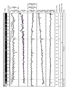
Figure 3: Hole 1127B below pipe: core recovery geophysical logs )caliper, gamma-ray, porosity, resistivity, sonic velocity, magnetic susceptibility), logging units, lithostratigraphic units, biostratigraphic ages.
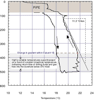
Hole 1127B was one of three holes in which the LDEO-TAP tool was run on the triple combo string. A down hole (logging speed: 1000 m/hr) and up hole (logging speed: 550 m/hr) temperature log was recorded (Figure 4). The LDEO-TAP was run above its optimum logging speed of 200-250 m/hr on both the down and up logs, and the temperatures measured on the up-log were also effected by fluid disturbance caused by tool motion. The slower logging speed of the up hole log means it is of better quality than the down hole log. Borehole fluid temperatures measured by the TAP are not formation temperatures. Circulation of drilling fluid (sea-water) acts to cool both fluid and formation temperature. The overall increase in temperature between the down hole and up hole log are caused by cool borehole fluid beginning to slowly heat up towards formation temperatures. However, it can take a period of up to several months before formation equilibrium temperatures are attained. Consequently the temperature profiles measured are minimum estimates of in situ borehole temperatures. None-the-less breaks in the geothermal gradient can be used to identify lithological boundaries related to changes in formation geothermal conductivity and permeability; and horizons of fluid or gas flow into or out of the borehole. A change in temperature profile from an essentially linear down hole increase (geothermal gradient ~11.3 °C/km) to highly variable temperatures occurs below 370 mbsf (Figure 4). A slight break in the general compaction trend is also observed on the sonic and porosity logs at 370 mbsf (Figure 3). This interval of irregular borehole temperatures is partially interpreted as reflecting higher and more varied formation permeabilities reflecting lithological alternations between grainstones, packstones and wackestones below 370 mbsf, that allowed cool drilling fluid to enter and cool the formation to different degrees. Return flow of drilling fluid from the formation after circulation stopped for logging may also have contributed to differential cooling of borehole fluid temperatures. An increase in formation thermal conductivity would also cause a decrease in geothermal gradient. High levels of hydrogen sulphide gas were recorded in this borehole and marked negative spikes in temperature that occur at 410, 440, and 474 mbsf may have been produced by gas entering the borehole at these depths, with cooling being caused by gas expansion. Pock-marks on the bore hole wall seen in the FMS images are present within this interval that could have been formed by gas entering the hole after coring was completed (Figure 5). The negative spike at 474 mbsf coincides with the upper boundary of a lithological subunit which has a grainstone cap providing a high permeability pathway for gas to have entered the borehole.
|
|
|
|
Figure 4: Hole 1127B below pipe: Down hole variations in borehole temperature measured by the LDEO-TAP tool on the triple combo string. Logging directions are indicated by arrows. Breaks in the temperature gradient may indicate changes in formation thermal conductivity, fluid pressure, fluid out flow, gas in flow and/or permeability. |
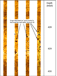
Figure 5: Hole 1127B: FMS image from Subunit 1B showing a number of highly conductive features (darker coloured) interpreted as water filled pock-marks in the borehole wall. The pock marks could have been formed by a gas pocket expelling gas into the borehole. Individual pock-marks are 5 to 8 cm across. |
Hole 1128D
Geological Setting
Hole 1128 is situated on the upper continental rise, near the toe of slope, at a water depth of 3874.6m (Figure 1). The succession consists of pelagic carbonates of Cenozoic-Mesozoic age overlying deep water siliciclastic sediments.
Logging Operations
The logging program carried out in Hole 1128D is summarised in Table 1. Overall hole conditions were good for logging. However, very high porosities of several underconsolidated horizons made porosity logs unreliable in some intervals.
Results
Plots of some of the conventional logs acquired from Hole 1128D below pipe along with core recovery, lithologic units, biostratigraphic ages are shown in Figure 6. As core recovery below 250 mbsf was poor down hole logs proved essential for subdividing and classifying the succession. The succession was subdivided into 4 logging units that closely correlate with lithologies and physical properties from core. Logging Unit 1 is classified into 2 subunits. The base of Subunit 1A is marked by the first appearance of debris flows described from core. Unit 1B is characterised by a down hole decrease in gamma-ray levels due to a loss of thorium, indicating reduced clay mineral content. Log Unit 2 is characterised by significant variability in all the logs. Variability in geophysical logs in Subunit 2A reflects claystone lithologies interbedded with chert and variability in lithification. Variability in Subunit 2B reflects thinly bedded calciturbidites (decreased gamma-ray, porosity, increased density, resistivity and sonic velocity) and terrigenous sandstones (high gamma-ray, low density, decreased velocity and appear as highly conductive horizons on the FMS images). The density and PEF peak at 342 mbsf correspond to a coarse terrigenous sandstone recovered in core. Logging Unit 3 correlates to silty clays and claystones recovered in core. Most logs in logging Unit 4 have minimum variability with the exception of cyclic variations in gamma-ray values.
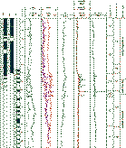
Figure 6: Hole 1128D below pipe: core recovery, geophysical logs (caliper, gamma-ray, porosity-density, photoelectric effect, resistivity, sonic velocity), logging units, lithostratigraphic units, biostratigraphic ages.
Hole 1129D
Geological Setting
Hole 1129D is located immediately seaward of the present day shelf-edge in 202.4 m of water and is situated at the proximal end of a north-south transect that includes Holes 1131A and 1127B (Fig. 1). Hole 1129D penetrated a succession that spans from the Miocene to the Quaternary.
Logging Operations
The logging program carried out in Hole 1129D is summarised in Table 1. Hydrogen sulphide was present in this hole and suitable precautions were taken (see introduction). A single pass was made with the FMS-Sonic. The WST recorded 10 stations, with individual stations located near log breaks and at the estimated depths of significant seismic reflectors. The WHC coped well with the moderate heave conditions. The acquired logs were of very good quality, except in the interval between 360-460 mbsf, were the porosity log was affected by significant borehole rugosity and washouts.
Results
Plots of the some of the conventional geophysical logs acquired from Hole 1129D below pipe are shown along with core recovery, lithological units and biostratigraphic ages in Figure 7. The overall lithology of the recovered core is of a clean (>90%) carbonate. Three major logging units are defined principally based on variations in gamma-ray and sonic logs and these units show good correlations to the lithostratigraphy. Each logging unit has a characteristic gamma-ray (HSGR) and uranium signature. Logging Unit 1 is characterised by comparatively high uranium gamma-ray with high frequency high magnitude variations. Organic material is low (0.4-0.7 wt%) and may be insufficient to account for the high uranium gamma-radiation. Other sources of uranium may be unclassified 'blackened grains' described in core, and diagenesis is also likely to have played a role. Logging Unit 2 is characterised by lower values of gamma-radiation which appears cyclic in nature. Unit 2 can be subdivided into 2 subunits based on a marked change in the character of the sonic log. Low-porosity and high density peaks associated with high gamma-ray radiation, and in some instances high PEF, values indicate potential firmgrounds, that increase in frequency in Subunit 2B. One of these intervals was recovered in core and contained pyrite which explained the high PEF values. Gamma-ray cycles in Unit 2 can be correlated with those described in Holes 1131A and 1127B (Figure 15) (see Discussion). Logging Unit 3 is characterised by uniformly low gamma-ray values and a variable PEF log indicating alternations of silica-rich beds with calcium carbonate beds: revealed in core to correspond to cherts intebedded with packstone/grainstones. The boundary between log Units 2 and 3 is seen on the FMS log, as are the alternations between more resistant chert beds and more conductive carbonates within Unit 3 (Figure 8). Separation of resistivity logs in Units 1 and 3 indicate typical fluid invasion profiles caused by the accumulation of mud cake on the borehole wall in permeable strata.
|
|
|
|
Figure 7: Hole 1129D below pipe: core recovery, geophysical logs (caliper, gamma-ray, porosity-density, photoelectric effect, resistivity, sonic velocity), logging units, lithostratigraphic units, biostratigraphic ages. |
Figure 8: Hole 1129D below pipe: FMS image showing the boundary between logging Units 2 and 3 which also coincides with an inflection in gamma-ray values. Chert horizons in unit 3 are imaged as resistive (bright) horizons, whereas the more conductive packstone-grainstone (Unit 3) and wackestone-packstone (Unit 2) intervals appear darker on the image. |
Hole 1130C
Geological Setting
Hole 1130C is situated on the upper slope of the eastern Eyre Terrace in 477.8 m of water (Figure 1). Hole 1130C penetrates through a thick succession of Pleistocene carbonates into the distal part of a progradational siliciclastic wedge of Palaeocene to probably Eocene age.
Logging Operations
The logging program carried out in Hole 1130C is summarised in Table 1. Hydrogen sulphide was present in this hole and suitable precautions were taken (see introduction). Two long passes with the triple combo were made. The first pass started at the base of the hole. However, the WHC failed 20 m off bottom due to a technical problem. The logging speed was increased to 550 m/hr to protect the logging tools and the pass logged to mudline without the WHC. A second pass was then made from 320 mbsf to mudline with the WHC functioning correctly. The log data from the second pass was of good quality except in the pipe were neutron activation caused by the first run corrupted the gamma-ray log. Two passes of the FMS-sonic were made. The WST recorded 8 check shots stations adjacent to boundaries indicated by the acquired logs. The WHC coped well with the moderate heave conditions. Despite minimum hole preparation before logging hole conditions proved very good for logging.
Results
Plots of some of the conventional logs acquired from Hole 1130C below pipe, along with core recovery, lithologic units and biostratigraphic ages are shown in Figure 9. Three large scale logging units were differentiated based on abrupt step shifts in gamma-ray logs. Variations in gamma-ray values in Unit 1 may be cyclic in character. Several low-porosity peaks, crossing the density curve, may indicate the occurrence of partially silicified beds within Unit 2, although PEF values indicate that calcium carbonate is the dominant overall lithology of the succession. The very low gamma-ray values in Unit 3 may reflect depletion of uranium during partial silicification of this unit. Small amounts of chalk encountered in the poor core recovery from Unit 3 indicate a lithology consisting of interbedded cherts and chalk/ooze. These interbeds are indicated by cross-overs on the porosity-density log and can be seen on the FMS images as alternations between resistive (chert) and conductive (calcium carbonate) layers.
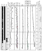
Figure 9: Hole 1130C below pipe: core recovery, geophysical logs (caliper, gamma-ray, porosity-density, photoelectric effect, resistivity, sonic velocity), logging units, lithostratigraphic units, biostratigraphic ages.
Hole 1131A
Geological Setting
Hole 1131A is located on the upper continental slope on the eastern Eyre Terrace immediately seaward of the present day shelf-edge in 333.6 m of water. Hole 1131A penetrated the flank of a seafloor mound and the underlying thick succession (< 500 m) of prograding clinoforms. The sucession is of middle Miocene to Pleistocene age. Hole 1131A is situated between Holes 1127B and 1129D which form part of a north-south transect across the margin (Figure 10).
Logging Operations
The logging program carried out in Hole 1131A is summarised in Table 1. Hydrogen sulphide was present in this hole and suitable precautions were taken (see introduction). A single pass was made with the FMS-Sonic. The WST recorded 8 check-shot stations located at log breaks and at estimated depths of significant seismic reflectors. Caving occurred in the top 240 mbsf were hole diameter occasionally saturated HLDS and FMS calipers and also produced artifacts in the porosity log (compare caliper and porosity logs in Figure 10). Hole centred tools were less effected by borehole conditions and produced good quality logs.
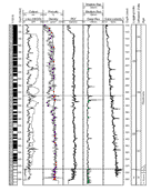
Figure 10: Hole 1131A below pipe: core recovery, geophysical logs (caliper, gamma-ray, porosity-density, photoelectric effect, resistivity, sonic velocity), logging units, lithostratigraphic units, biostratigraphic ages.
Results
Plots of the some of the conventional geophysical logs acquired from Hole 1131A below pipe are shown along with core recovery, lithological units and biostratigraphic ages in Figure 10. Variations in the conventional geophysical logs allowed the succession to be subdivided into 3 logging units (Figure 10). Logging Unit 1 is defined using natural gamma-ray measured through pipe and correlates with a bryozoan rich horizon described in core. A uranium gamma-ray peak marks the base of logging Unit 1. During life bryozoans require a hard substrate which to attach themselves and this peak may identify a firmground. Logging Unit 2 is characterised by what appears to be marked cyclicity in the uranium gamma-ray log possibly becoming more pronounced in Subunit 2A. Gamma-ray cycles in Unit 2 can be correlated with those described in Holes 1127B and 1129D (Figure15) The boundary between logging Subunit 2A and 2B is defined by a change in the character of the sonic log from relatively smooth to exhibiting higher frequency and high amplitude excursions. This boundary coincides with peaks in uranium gamma-ray, density, resistivity and sonic logs, and a low porosity peak, and probably represents a firmground that is also seen on the FMS log. The relatively high levels of uranium gamma-ray in log units 1 and 2 is unusual for what is a dominantly carbonate succession. Blackened grains were again observed in core. Unit 3 is characterised by uniformly low gamma-ray. The occurrence of porosity-density cross-overs that coincide with low PEF values and high resistivity and sonic values in logging units 2 and 3 are interpreted as likely chert layers, whereas low-porosity peaks associated with density, PEF, sonic, resistivity and sometimes gamma-ray peaks identify potential firmgrounds. The significance of uranium gamma-ray peaks and cycles in carbonates is expanded in the Discussion section. Chert horizons and firmgrounds can clearly be seen on the FMS images (Figure 11). Suspected firmgrounds are frequently associated with gamma-ray peaks in the hole. Continuous uranium enrichment for 2-3 m above some suspected firmgrounds may represent condensed sections deposited when sedimentation rates were slow during the initial resumption of sediment accumulation (Figure 11). Firmgrounds formed during depositional hiatuses are candidates for key sequence stratigraphic surfaces. These hard horizons defined from geophysical logs were not observed in the recovered core where they correspond with intervals of non-recovery. These hard horizons were also recorded in the relative difficulty of drilling. The alternation of harder horizons with softer strata appears to be the cause of preferential non-recovery of more lithified horizons and candidate firm and hardgrounds.
Figure 11: Hole 1131A: FMS image showing a firmground (bright coloured) at the boundary between Subunits 2A and 2B. High levels of (uranium) gamma-ray are associated with the firmground and the overlying 3 metre interval. The concentration of uranium in the interval immediately overlying the firmground may represent a condensed section recording slow sedimentation.
Hole 1132C
Geological Setting
Hole 1132C is situated immediately seaward of the shelf-slope break of the eastern Eyre Terrace at a water depth of 218.5 m and provides a record of Eocene to Holocene to carbonate deposition.
Logging Operations
The logging program carried out in Hole 1132C is summarised in Table 1. Hole 1132C was logged after drilling was abandoned due to deteriorating hole conditions. Hydrogen sulphide was again detected in this hole. During tripping pipe prior to logging weighted mud was circulated to reduce fluid back-flow in the borehole. Barite present in this mud appears to have remained in the hole and corrupted the PEF log, which gives spuriously high values. The triple combo touched bottom at 561 mbsf. However, significant hole deterioration meant that the FMS-Sonic tool string was only able to penetrate to 176 mbsf.
Results
lots of the some of the conventional logs acquired from Hole 1132C below pipe are shown, along with core recovery, lithological units and biostratigraphic ages in Figure 12. Variations in the conventional logs allow the succession to be subdivided into 4 logging units (Fig. 12). Possible cyclic alternations in gamma-ray values occur in Unit 1. The increase in cross-overs between porosity and density logs in log Unit 2 reflects the occurrence of many thin chert horizons intebedded with limestone. Most of the logs in Unit 3 are remarkably uniform reflecting homogenous grainstones strata. Increased gamma-ray values in log Unit 4 are caused by an increase in thoriun and potassium levels and may reflect ingress of some terrigenous sediments into the otherwise carbonate dominated environment during deposition. Separation of shallow, deep and intermediate resistivity logs for much of the section indicates a classic invasion profile. Invasion of circulating fluids into permeable strata during drilling has formed a mud cake on the borehole walls.
Figure 12: Hole 1132C below pipe: core recovery, geophysical logs (caliper, gamma-ray, porosity-density, resistivity, sonic velocity), logging units, lithostratigraphic units, biostratigraphic ages.
Hole 1134A
Geological Setting
Hole 1134A is situated on the upper slope of the eastern Eyre Terrace in 701 m of water and penetrates a middle Eocene to middle Pleistocene succession.
Logging Operations
The logging program as carried out in Hole 1134A is summarised in Table 1. Two passes were made with the FMS-Sonic string. The WHC coped moderately well with the medium to high heave conditions except on the first pass of the FMS-Sonic when the WHC stroked out at 158 mbsf and the FMS calipers had to be closed to protect them from down heave. Seven check shot stations situated at log breaks and at estimated depths of significant reflectors were recorded using the WST.
Results
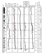
Plots of the some of the conventional logs acquired from Hole 1134A below the pipe are shown, along with core recovery, lithological units and biostratigraphic ages in Figure 13. Overall geophysical logs are quite similar to those at Hole 1126D, which is located in a comparable part of the platform situated further to the east. However, gamma-ray logs in Hole 1134A display markedly higher values than those at Hole 1126D. The succession was divided into 6 logging units based on variations in the entire suite of logs. Log units closely match lithostratigraphic unit boundaries described from core. Logging units are characteristic of lithological alternations between calcareous ooze, wackestone, grainstones, and the occurrence of thin chert interbeds. Logging Unit 1 is subdivided into 3 subunits on the basis of the gamma-ray log measured through pipe (Fig. 14). Subunit 1A is characterised by high and variable gamma-ray values that may be cyclical. Subunit 1B is characterised by intermediate gamma-ray values and Subunit 1C, which spans the pipe and open hole interval, by very low gamma-ray values. The principal source of gamma-ray is uranium. Glauconite observed in core from this interval is one factor contributing to the high gamma-ray (potassium) values. The presence of unidentified "blackened grains" described in core also coincide with higher values of gamma-ray indicating the grains have a possible phosphatic and/or glauconitic composition. Positive density and porosity separation and relatively high PEF values indicate the presence of dolomite towards the top of the succession (Logging Unit 1). Logging Subunit 1A and 1B may correlate with logging units 1 and 2 in Hole 1126D. Logging Unit 2 is characterised by high gamma-ray levels. Narrow separation of density and porosity logs and relatively low PEF values indicate a less clean carbonate in logging Unit 2, and the presence of some quarts: which was confirmed in core. Logging Unit 2 may correlate with logging Unit 3 in Hole 1126D. Logging Unit 3 is characterised by a decrease in gamma-ray values. Geophysical logs also identify an interval of unusually very low potassium content in logging Unit 3, the significance of which is still to be established. Log Unit 3 may correlate to the upper part of Log Unit 4 in Hole 1126D. Log Unit 4 is characterised by relatively uniform high gamma-ray values and is not readily correlatable to Hole 1126D. Thin chert, and silicified beds, indicated by the conventional logs and also observed in core, are clearly seen on the FMS images. Logging Unit 5 shows little variation in gamma-ray logs and may correlate with log units 6 and 7 in Hole 1126D. Density, PEF, caliper and resistivity were the only logs acquired in the sandstone at the base of the succession (Logging Unit 6). High density and high PEF peaks are consistent with the small amount of limonitic sandstone recovered from this horizon which may correspond to log Unit 8 in Hole 1126D.
|
|
|
|
Figure 13: Hole 1134A open hole interval: core recovery, geophysical logs (caliper, gamma-ray, porosity-density, photoelectric effect, resistivity, sonic velocity), logging units, lithostratigraphic units, biostratigraphic ages. |
Figure 14: Hole 1134A through pipe: Spectral gamma-ray logs from the HNGS plotted on an expanded scale to show variations in the interval logged through pipe. Columns left to right are: core recovery, total gamma-ray (HSGR), and computed (uranium free) gamma-ray (HCGR); uranium (HURA); thorium (HTHO); potassium (HFK); logging units; lithostratigraphic units; biostraigraphic ages. |
Discussion
The Significance of Pleistocene Gamma-ray Cycles
Holes 1127B, 1131A and 1129D are located along a seawards trending shelf-edge to upper foreslope transect. (Fig. 1). Hole 1129D is situated at the proximal end of the transect and Hole 1127B at the more distal end of the transect. Cycles of Pleistocene age in the gamma-ray logs can be correlated laterally between these sites. This package of cycles occurs immediately above the base of seismic Sequence 2 (Feary and James 1998). There is a slight increase in gamma-ray levels as traced up slope. A preliminary very tentative correlation of cycles in these three holes is shown in Figure 15. Gamma-ray cycles are on average 10-25m thick. Cycles were also described in core but are of a larger scale and lower frequency. Prograding clinoforms can be traced from the shelf-edge to foreslope on the seismic profile of the margin.
Figure 15: Preliminary correlation of Pleistocene gamma-ray cycles between Holes 1129D, 1131A and 1127B which form a north-south transect across the margin. Blue- water column; grey- pipe.
The HNGS spectral gamma-ray logs shows that theses cycles are caused by variations in uranium content. The level of uranium in these cycles is unusually high for a succession which is essentially composed of clean carbonates: as indicated by porosity-density and PEF logs, and from the recovered core and XRD analysis. Pure calcium carbonate does not contain radioactive minerals. Some aragonite is present, but alone may be insufficient to account for the high levels of gamma-radiation. It is therefore highly likely that diagenesis played a major role in forming the gamma-ray cycles. Uranium can be diagenetically concentrated by absorption into organic matter, and the slight increase in gamma-ray values towards the proximal end of the transect may reflect an increase in the content of organic material shoreward. However, the content of organic matter in the succession is low, averaging approximately 1%, and other diagenetic processes are likely to have been important in concentrating uranium.
Many uranium peaks appear to be associated with more lithified horizons indicated by concurrent peaks in the other geophysical logs (resistivity, sonic velocity, and porosity-density cross-overs) and also imaged on FMS logs, that identify potential firm or hardgrounds. Very few firm/hardgrounds were recovered in core, but intervals of non-recovery frequently coincided with harder horizons identified from the logs and were also recorded during drilling. The preferential non-recovery of these horizons reflects the difficulty of coring though alternating hard and soft strata. Firm/hardgrounds form during significant reduction in sedimentation rate or depositional hiatuses. There are several diagenetic mechanisms for concentrating uranium. Remobilized uranium can become concentrated at oxidation fronts (Colley and Thompson 1985) and be incorporated into carbonate fluorapatite, possibly at hardgrounds (Serra 1984). Both of these mechanisms may be favoured by a reduction in sedimentation rate. However, as uranium is excluded from re-precipitated calcite, calcite cemented horizons may become depleted in uranium. 'Blackened grains' observed in the cores often coincide with high gamma-ray intervals. The exact composition of these grains is still to be established but the 'blackened grains' could be phospatic and/or glauconitic in composition, thus providing a potential source of uranium and potassium. Phospatized grains are frequently deposited above depositional unconformities (e.g., Delamette 1994). Glauconite and phosphatized grains may also be reworked downwards into firm/hardgrounds i.e. as part of burrow in fill, and be reworked in the condensed section deposited immediately above the firm/hardground during the initially slow resumption of sediment accumulation. The precision of uranium gamma-ray logs has been questioned (e.g., Hurst 1990), so it is possible that gamma-peaks occur immediately above rather than at potential firm/hardgrounds themselves.
Decreases in sedimentation rate may reflect changes in accommodation space related to relative sea-level fluctuations (e.g., Sarg 1988) and/or reflect shifts in the distribution of sediment supply between in situ deposition in the carbonate factory versus off-platform export to the foreslope (e.g., Schlager 1991). In the former scenario gamma-ray peaks may identify depositional hiatuses that correspond with key sequence stratigraphic surfaces, i.e. parasequences and sequence boundaries. Sea-level fluctuations in the Pliocene-Pleistocene are thought to be related to glacial-interglacial climatic alternations controlled by astronomical cycles (orbital eccentricity, axial obliquity, precession of equinoxes). Using spectral analysis and paleontologically determined variations in sedimentation rates it will be possible to establish the periodicity of gamma-ray cycles and determine any link to orbital forcing.
Progradation requires the preferential export of sediment from the carbonate factory to the foreslope. The most likely mechanisms for this sediment transfer are suspension and traction flows driven by marine-currents or storm action. In this scenario gamma-ray peaks would record breaks in progradation on the slope during quiescent periods when these mechanisms were not operating. Gamma-ray cycles could thus be linked to changes in the distribution of gross sediment platform budget connected to environmental changes likely to include the paleoceanographic development of the Leeuwin current in the Great Australian Bight. However, changes in sediment budget, marine-currents and relative sea-level fluctuations are not mutually exclusive and the gamma-ray cycles may record a polygenetic signature of environmental changes.
Future Research
1. Mineralogy
Geophysical log data will be analysed using mineral inversion transforms to determine the quantitative mineralogy of the penetrated strata in each hole. This provides the only way to determine the mineralogy of intervals in which core recovery was poor. Mineralogical profiles through the margin will then be used to investigate cool water diagenesis, dolomitization, and fluctuations of CCD linked to relative sea-level changes.
2. Interpretation of FMS and conventional logs
FMS images and the conventional logs, especial the gamma-ray logs, will be used to investigate stratal stacking patterns and cyclicity in a sequence stratigraphic context. Geophysical logs will be used to determine the roles of in situ sediment accumulation versus redeposition by gravity flows in fuelling platform progradation and their relationships to relative sea-level fluctuations and other environmental changes.
References
Colley, S., and Thompson, J., 1985. Recurrent uranium relocations in distal turbidites emplaced in pelagic conditions. Geochemn. cosm chim. Acta 49: 2399-2384.
Delamette, M., 1994. Les séries phosporites aptiennes cénomaniennes de la plateforme helvétique en Haute-Savoie et en Valais: stratigraphie et essai d' interprétation séquentielle (Alpes externes, France et Suisse): Université Genève Département géologique et paléontologique, Publication, v. 14, p. 101-135.
Feary, D.A. and James, N.P., 1998. Seismic stratigraphy and geological evolution of the Cenozoic, Cool water, Eucla Platform, Great Australia Bight. Amer. Assoc. Petr. Geol. Bull. v.82: 792-816.
Hurst, A., 1990. Gamma-ray spectrometry in hydrocarbon sandstones from Norwegian Continental Shelf. In: , A. Hurst, M.A. Lovell and A.C. Morton (Editors), Geological Applications of Wireline logs. Geological Society, London, p. 211-222.
Rider, M.H., 1996. The geological interpretation of well logs, 2nd edition. Whittles Publishing, 280 pp.
Sarg, J.F., 1988. Carbonate Sequence Stratigraphy. In: C.K. Wilgus, S.B. Hasting, C. St C. Kendall, H.W. Posamentier, C.A. Ross, J. C. van Wagoner (Editors), Sea-level Changes an Integrated Approach. Spec. Publ. Soc. Econ. Paleot. Miner. 42: 155-18
Serra, O., 1984. Fundamentals of well-log interpretation: 2. The interpretation of logging data. Elsevier, pp. 413.
Schlager, W., 1991. Depositional bias and environmental change -important factors in sequence stratigraphy, Sedimentary Geology, v.70: 109-130.